Journalism of Courage

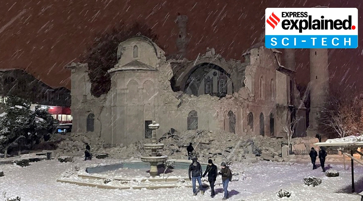 People walk next to a mosque destroyed by an earthquake in Malatya, Turkey. A powerful quake has knocked down multiple buildings in southeast Turkey and Syria and many casualties are feared. (Photo: Associated Press)
 Early Monday morning (February 6), an earthquake of magnitude 7.8 struck south-central Turkey and Northwest Syria, reported AP. Buildings across the region were seen tumbling down, sparking a mad scramble to find survivors in the rubble and amidst an ongoing snow storm in many places.
Reports have put the number of fatalities over 1,300 with thousands injured. This event is likely to be a humanitarian catastrophe in a region already ravaged by over a decade-long civil unrest and a refugee crisis.
Many survivors have claimed that this is the strongest quake they have felt in their lives. “I have never felt anything like it in the 40 years I’ve lived”, Erdem, a resident of the Turkish city of Gaziantep, near the quake’s epicentre, told Reuters. Videos of buildings being razed to dust have been circulating on social media.
In #Sanliurfa the moment a building collapsed recorded by mobile phone hours after 7.8 #earthquake hits Turkey. #deprem pic.twitter.com/YDc8DH9lbn
— JournoTurk (@journoturk) February 6, 2023
A magnitude of 7.8 on the Moment Magnitude scale is indeed really strong. According to experts, the quake is the joint largest on record (since roughly 1900) in Turkey. It has the same magnitude as one that killed about 30,000 people in December 1939 in northeast Turkey, tweeted Stephan Hicks, a researcher in seismology at the Imperial College London.
Just looking at the distribution of magnitude 7 and greater quakes since instrumental records began (~1900), today’s M7.8 event is by far the largest quake ever recorded in this region.
Most large earthquakes have occurred along the Northern Anatolian Fault in N. Turkey. pic.twitter.com/O7GP4iQsfz— Stephen Hicks 🇪🇺 (@seismo_steve) February 6, 2023
The U.S. Geological Survey (USGS) said the quake was centred about 33 km from Gaziantep, around 18 km deep, reported AP. This is a highly populous region, exponentially increasing the likelihood of casualties. The effects of the quake were felt across West Asia, Northern Africa and South Eastern Europe with residents of Lebanon, Cyprus, Greece, Israel and Egypt also reporting tremors, wrote The Guardian.
The earth’s crust is broken up into tectonic plates that are constantly moving, slowly, often getting stuck at their edges due to friction. When the stress on the edge overcomes the friction, there is an earthquake that releases energy in waves that travel through the earth’s crust, resulting in the vibration felt.
A network of seismographs are used to record earthquakes with each individual seismograph recording and measuring the movement of the ground in its location. A seismograph is securely mounted onto the surface of the earth so that when the earth shakes, the entire unit shakes with the exception of the mass on the spring, which remains in its place because of inertia.
 A Kinemetrics seismograph. (Wikimedia Commons)
During shaking, the recording device on this mass records the relative motion between itself and the rest of the instrument, thus recording the ground motion. According to the USGS, these mechanisms are no longer manual, but instead work by measuring electronic changes produced by the motion of the ground with respect to the mass.
Today, there are many measures of an earthquake’s magnitude, with the most famous (and outdated according to USGS) being the Richter Scale.
Devised in 1935 by Charles Francis Richter, the Richter Scale (denoted as ML) is a logarithmic scale, where each step represents a tenfold increase in magnitude. Thus, an earthquake measuring 7 on the Richter Scale has 10 times the magnitude of one measured 6. The scale was calibrated by defining a magnitude 0 shock as one that produces (at a distance of 100 km) a maximum amplitude of 1 micron using the Wood-Anderson seismograph.
According to the USGS, as more seismograph stations were installed around the world, it became apparent that the method developed by Richter was strictly valid only for certain frequency and distance ranges. Consequently, the Moment Magnitude Scale (denoted as Mw) was developed.
According to the USGS, a Moment is a physical quantity proportional to the slip on the fault multiplied by the area of the fault surface that slips. Thus, it is related to the total energy released in the earthquake. This scale provides a more accurate estimate of magnitude, especially as one goes higher up the scale. Like the Richter Scale, this too is a logarithmic scale.
In many ways, the intensity is an even more important measure of an earthquake as it is related to the tangible impact a quake has. Intensity scales, like the Modified Mercalli Scale and the Rossi-Forel scale, measure the amount of shaking at a particular location.
An earthquake causes many different intensities of shaking, depending on how deep it is located on the earth’s crust and how far it is from its epicentre. Earthquakes of lower magnitude can be more intense if they are located in more shallow ground or if the area where they occur has more loose soil, etc.
The Modified Mercalli Scale, the most commonly used intensity scale, ranks earthquake intensity on a scale of I. (not felt) to XII. (extreme). The maximum intensity measured in today’s Turkey earthquake is IX. or violent – “Damage is considerable in specially designed structures; Damage is great in substantial buildings, with partial collapse. Buildings are shifted off foundations. Liquefaction occurs. Underground pipes are broken”, according to the USGS website.