
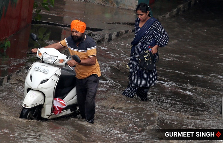
 A street left waterlogged after heavy rain in Delhi (Express photo by Praveen Khanna)
Weather Forecast Today Live Updates: Odisha observed a shortage in rainfall this year between June 1 and August 23, which has adversely affected agricultural activities across the state. According to PTI, Odisha received only 571 mm of rain since June as against the anticipated 820.5 mm, leading to a 30.3 per cent deficit rainfall.
While according to S K Vashisth, the principal secretary of agriculture and famers’ empowerment department, there is “no drought situation anywhere”, the state government has directed the collectors to ensure that agricultural workers get jobs under MGNREGA or other state schemes as a measure to mitigate the “dry spell”
Meanwhile, the India Meteorological Department (IMD) has forecast that parts of Northeast India, including Sikkim, sub-Himalayan West Bengal, Assam and Meghalaya, are likely to receive heavy rainfall till August 27. Whereas, widespread rainfall is expected to continue in Bihar, East Uttar Pradesh and Uttarakhand till August 27. Tamil Nadu, Kerala and Maharashtra will witness rainfall activity on August 23, 26 and 27.
While most parts of the country will witness rainfall activity, Rajasthan is likely to see dry weather from August 25 to 27.
 The rain will continue in these districts for the next two hours. (Express Photo)
The maximum temperatures on Monday stayed close to normal levels in most parts of Punjab and Haryana.
Chandigarh, the common capital of both states, registered 33 degrees Celsius, according to a media bulletin of the Meteorological Department here.
In Haryana, Ambala, Hisar and Karnal registered maximum temperatures of 33.2, 33.5 and 32.8 degrees Celsius, respectively. Narnaul, Rohtak and Gurgaon registered their respective maximum temperatures at 32.8, 34.6 and 35 degrees Celsius, respectively.
In Punjab, the maximum temperatures of Amritsar, Ludhiana, Patiala and Bathinda settled at 34, 33.3, 33.6 and 33.2 degrees Celsius, respectively. (PTI)
Rains occurred in various parts of Rajasthan over the past 24 hours with Thanagazi of Alwar district recording 72 mm rainfall, a Meteorological department official said on Monday.
In the last 24 hours, 68 mm rain was recorded in Shrimadhopur in Sikar, 65 mm in Viratnagar in Jaipur, 47 mm in Bundi's Taleda, 46 mm in Choti Sadri of Pratapgarh. Apart from this, many places in Ajmer, Baran, Chittorgarh, Jhunjhunu, Rajsamand, Bharatpur and Bhilwara recorded significant rainfall.
Rains will recede in the state from Tuesday and the weather is likely to remain mainly dry in most parts of the state during August 25 to 28. (PTI)
According to the IMD, thunderstorm with light to moderate intensity rain would occur over parts of Haryana (Palwal, Aurangabad, Manesar, Sohna) and Uttar Pradesh (Jahangirabad, Jattari, Gulaoti, Khurja) during the next hours.
The Bhitarkanika National Park in Odisha on Monday launched a week-long census of seasonal monsoon birds which throng the wetland sites for nesting every year, an official said. Four teams comprising 10 ornithologists and wildlife personnel of the national park in Kendrapara district are conducting the headcount of these avian species.
Over a dozen types of local residential birds congregate at the heronries, in and around the national park, for nesting, and breeding every year, Forest Range Officer Manas Das said. The species are open bill stork, little cormorant, intermediate egret, purple heron, darters, white ibis and others, he said. Their arrival at the marshy wetland spots in Bhitarkanika National Park got delayed this year as the rainfall was not uniform during the monsoon. Still, an impressive congregation of monsoon birds has been spotted. (PTI)
A house was damaged by a boulder in Shimla, Himachal Pradesh due to a landslide following heavy downpour.
According to the IMD, parts of Uttar Pradesh (Hathras, Iglas, Raya) will witness thunderstorm with light to moderate intensity rain during the next two hours.
Delhi recorded a maximum temperature of 35.2 degrees Celsius, two notches above the normal for the season, and a minimum temperature of 26.2 degrees Celsius on Monday, according to the IMD. Till 5:30 pm, the national capital's relative humidity was at 66 per cent and it had received 2 mm rainfall.
On Tuesday, city is likely to witness generally cloudy skies with chances of light rains.
With Maharashtra’s Vidarbha region having received 11 per cent less rain below normal this year, farmers are a worried lot. Nearly a month after sowing was completed in mid-July, farmers believe the quantity and quality of kharif crops will be hit badly if the deficit continues till the end of this month.

Although the state, as a whole, has received 7 per cent more rain between June 1 and August 22, it was mostly in Marathwada and Central Maharashtra. Drought-prone Marathwada, comprising eight districts, has received 533.4 mm rain so far compared to the usual 446 mm, a 20 per cent increase. Central Maharashtra received 595.6 mm against the normal 547 mm, an increase of 9 per cent.
But Vidarbha region, which comprises eleven districts, received only 631 mm rain compared to the normal index of 705.1 mm, according to the Indian Meteorological Department. Read more.
Odisha has observed a shortage in rainfall this year between June 1 and August 23, which has adversely affected agricultural activities across the state. According to PTI, Odisha received only 571 mm of rain since June as against the anticipated 820.5 mm, leading to a 30.3 per cent deficit rainfall.
S K Vashisth, the principal secretary of agriculture and famers' empowerment department, explained that "thirty blocks in 15 districts are experiencing moisture stress condition, which have severely affected crops. There is, however, no drought situation anywhere". Vashisth also said that the chief secretary has directed the collectors to ensure that agricultural workers get jobs under MGNREGA or other state schemes, as and when necessary. "In places, where paddy cultivation has suffered damage due to low rainfall, farmers would be encouraged to grow alternative crops amid the dry spell," he added.
Towards Monday afternoon, the IMD has forecast the Pune city’s weather to turn partly cloudy with possible light intensity rain (2.mm to 15.5mm in 24 hours). The day temperature will be around 29.7 degrees and the recorded minimum temperature was 19.4 degrees.
Parts of Haryana (Bhiwani, Mattanhail, Kosali) and Uttar Pradesh (Jalesar, Sadabad, Sikandra Rao, Iglas) will receive light to moderate intensity rains during the next two hours, the IMD tweeted.
Scattered to fairly widespread rainfall with isolated heavy fall over Tamil Nadu, Kerala and Maharashtra on August 23, 26 and 27.
Isolated extremely heavy falls are likely to take place over Assam and Meghalaya from August 23 to August 25.
Fairly widespread to widespread rainfall with isolated heavy falls will continue over Bihar, East UP and Uttarakhand till August 27.
Widespread rainfall activity with isolated heavy to very heavy falls is very likely to continue over Northeast India, Sub-Himalayan West Bengal & Sikkim till 27th August.
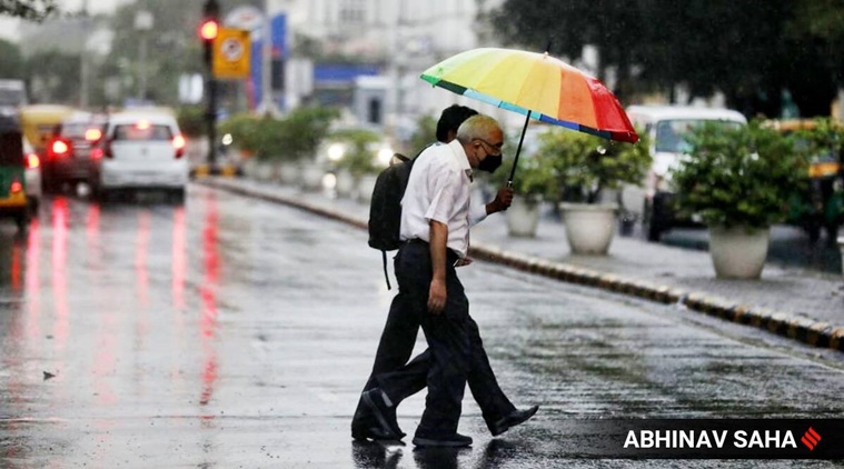
Light rainfall and thundershowers are expected in the national capital. The maximum temperature will settle around 34 degree celsius.
There will be light intensity rain over and adjoining areas of isolated places of Delhi, Hapur, Gulothi, Siyana during the next 2 hours.
The week over Pune began with clear sky and sunny conditions.
Towards Monday afternoon, the India Meteorological Department has forecast the city's weather to turn partly cloudy with possible light intensity rain (2.4mm to 15.5mm in 24 hours).
The day temperature will be around 29.7 degrees and the recorded minimum temperature was 19.4degrees.
The city's Air Quality Index (AQI) for Monday is 33 which is categorised 'good', a forecast issued by the SAFAR - India of the Indian Institute of Tropical Meteorology, Pune.
Thunderstorm with light to moderate intensity rain would occur over and adjoining areas of Rajaund (Haryana) Bagpat, Khekra, Modinagar, Kithor, Pilakhua, Hapur, Gulaoti, Siyana, Sambhal, Sikandrabad, Chandausi, Jahangirabad, Anupshahar, Bahajoi, Shikarpur, Debai, Narora (U.P.) during next 2 hours. --- IMD
As heavy rains lashed Noida and Ghaziabad, the cities witnessed heavy waterlogging in several areas on Saturday. From flooding in a housing society to lake-like stretches of water on streets, residents faced a difficult time commuting during the day.
As per the Met department website, Gautam Buddh Nagar recorded 25 mm rainfall while Ghaziabad received 27 mm, against 5 mm of normal rainfall, till 8.30 am on Saturday. Read more
After a brief revival last week, which led to a few intermittent but heavy spells over parts of Maharashtra, especially over Marathwada, the southwest monsoon will once again take a break this week.
With the likely northward shifting of the monsoon trough expected from Monday, the India Meteorological Department (IMD) has said that rainfall activity, mainly over northwest India, including Maharashtra, will decrease this week. Read more
Here are five nutrition mistakes you should avoid during the monsoon to remain healthy, as advised by dietitian Mac Singh, founder of Fitelo.
1: Avoiding citrus fruits
Citrus fruits are a great source of vitamin C. Vitamin C is great for your immunity as it fights infections, making it the need of the hour. Owing to the sourness of these fruits, people tend to avoid them during the monsoon, thereby compromising their immunity.
If you do not like consuming citrus fruits as a whole, you can always sprinkle a lemon on your food or make yourself a nice fruit drink. If you really cannot have citrus fruits, do not forget to consume foods such as papaya, guava and bell pepper as these are rich sources of vitamin C. Read more
Delhi has witnessed excess rainfall of around 21% so far this monsoon season. Between June 1 and August 22, the national capital has recorded 511.1 mm of rainfall compared to a normal average of 422.8 mm.
While New Delhi and North Delhi have witnessed ‘large excess’ rainfall, which is more than 60% above the long period average, Central Delhi, Northwest Delhi, and Southwest Delhi have recorded ‘excess’ rainfall – around 20% to 59% above the long period average. Northeast Delhi has registered a deficit, with rainfall being 50% below average. Read more
Following heavy rainfall on Sunday, the water in Chandigarh's Sukhna Lake crossed the 1162.5-feet mark, nearing the danger mark set at 1163-feet.
The maximum temperature in Delhi settled at 34.3 degrees Celsius Sunday, the meteorological department said. Rains lashed some parts of the city on Sunday morning, and the minimum temperature settled at 24.5 degrees Celsius, two notches below the season's normal, said the official.
In the last 24 hours, the city received 9.2 mm rainfall, they said. The maximum and minimum temperatures on Monday are expected to be around 35 and 26 degrees Celsius, respectively. (PTI)
Parts of Haryana (Barwala, Hansi, Meham) and Rajasthan (Tizara, Kotputli, Alwar, Viratnagar, Nagar, Deeg, Laxmangarh, Rajgarh, Bayana) will witness thunderstorms with light to moderate intensity rains over the next two hours, the IMD tweeted.
Several commuters on Sunday faced difficulty as parts of Ludhiana witnessed water-logging amid heavy rainfall. The photos below show water-logging at the Lodhi Club underpath.
Amid heavy downpour on Sunday, parts of Bhatinda in Punjab saw commuters wading through water-logged roads.

While the IMD had issued an orange alert for some parts of Madhya Pradesh, the state did not recieve heavy rainfall in the past 24 hours. A senior IMD Bhopal's official told news agency PTI that the rains weakened over the state on Sunday as a cyclonic circulation was now lying over north-east Rajasthan and its vicinity.
However, Shivpuri in north MP and Sidhi in the eastern part of the state are likely to see light to moderate rains, IMD said, due to a passing monsoon trough.
Watch people enjoying the cloudy weather at Sukhna Lake in Chandigarh Sunday.
Light showers and thunderstorms are expected in Delhi today with the India Meteorological Department (IMD) predicting that the maximum temperature is likely to be around 33 degrees Celsius.
The minimum temperature is expected to be 25 degrees Celsius, while the relative humidity at 8.30 am on Sunday stood at 92%. A cyclonic circulation over northeast Rajasthan and the position of the monsoon trough (south of its normal position) would result in light to moderate rainfall over parts of Delhi-NCR in the next 24 hours, the IMD said in a morning update on Sunday. The cyclonic circulation is likely to become less marked by Monday, and the likelihood of rainfall over Delhi and other parts of Northwest India would reduce, according to the IMD.
Light to moderate rainfall was recorded at most places in the eastern part and at a few places in the western part of Rajasthan during the last 24 hours, a Meteorological (MeT) Department official said on Sunday.
Heavy rain was recorded at one or two places in Bhilwara, Kota, Nagaur and Alwar districts during this period. The highest rainfall was recorded 118 mm in Alwar's Govindgarh. The official said that during the last 24 hours, 10 cm rain was recorded at Kota airport, 10 cm in Merta city of Nagaur, 9 cm in Alwar's Kotkasim, 8 cm in Ladpura of Kota, 5 cm in Jhalawar's Khanpur, 5 cm in Dholpur tehsil, 5 cm in Sikar, 5 cm in Kota's Ramganjmandi, 5cm in Bundi, 5 cm in Churu's Sujangarh, 5 cm in Barmer's Gadra Road. (PTI)
Maharashtra's Raigad district has recorded 2,823 mm rains so far since June, which is 89 per cent of its average annual rainfall, an official said on Saturday. In the last 24 hours ending at 8.30 am, Alibaug has recorded 70 mm rains, followed by Matheran with 56.40 mm, Mhasala with 56 mm, Karjat with 48 mm and Poladpur with 43 mm, while Murud recorded the lowest at 24 mm, the official said.
According to the information released by the Collector's office, Murud has recorded 122.90 per cent of its average annual rainfall, while Shirvardhan has seen 111.37 per cent showers.
The India Meteorological Department (IMD) on Saturday issued an orange alert predicting heavy to very heavy rains, ranging from 64.5 mm to 204.4 mm, in four districts in western Madhya Pradesh even as showers continued to lash large parts of the state. The IMD also issued two separate yellow alerts warning of heavy rains, a thunderstorm and lightning strikes in the 28 districts of the state. All three alerts are valid till Sunday morning, an IMD official said. According to the orange alert, heavy to heavy rainfall accompanied by thunder and lightning might occur in isolated places in Dhar, Ratlam, Ujjain and Dewas districts, PK Saha, a senior meteorologist with the IMD's Bhopal office, said.
Fairly widespread rains are also likely over peninsular India during the next 5 days. Tamil Nadu, Puducherry, and Andhra Pradesh will witness heavy isolated showers today. From tomorrow, rainfall activity and intensity will increase in the north-eastern parts of the country. West Bengal, Sikkim, Assam, and Meghalaya will see heavy rainfall from August 24 to 25.
The current rainfall activity over plains of northwest and central India is set to continue till August 23 and reduce thereafter. For today, the Met department has predicted heavy rainfall over parts of Punjab, Haryana, Rajasthan, Uttar Pradesh, and Maharashtra.
Rains lashed several parts of Punjab and Haryana on Saturday, providing the much-needed relief to people from the hot and humid weather conditions. The maximum temperatures dropped several notches below normal following the rains, the Meteorological Department here said. However, rain left some places waterlogged, causing inconvenience to the people. Chandigarh, the common capital of both the states, registered 26.7 degrees Celsius, seven degrees below normal. The city witnessed 20.8 mm of rainfall. In Haryana, Ambala, Hisar and Karnal registered maximum temperatures at 27.1, 29 and 26.4 degrees Celsius, up to seven degrees below normal, according to a media bulletin of the Meteorological Department here.