© The Indian Express Pvt Ltd

 The Red Fort came up across what is now the Ring Road, in 1648, on the west bank of a braid of the Yamuna.
 The Red Fort on one side and Salimgarh Fort on the other, separated by a braid or spill channel of the Yamuna — a scene from several 19th-century paintings of the Mughal city of Shahjahanabad — was recreated on Thursday, albeit during a flood.
The Yamuna in Delhi, which is for the most part of the year no more than a ribbon of polluted water, rose to 208.66 metres on Thursday evening, causing Delhi’s worst flooding on record. The river touched 207.49 m in 1978, the year in which records started to be maintained. The danger mark in Delhi is 205.33 m.
Ring Road was submerged, and water lapped the walls of the Red Fort and Salimgarh Fort. Kashmere Gate, Civil Lines, ITO, and Rajghat were flooded. Delhi government officials said the regulator at the Indraprastha Metro station gave way under pressure from the swollen river, which made its way onto the arterial road.
There was water on the Ring Road and in several residential neighbourhoods during the 1978 flood as well — however, the floodplains of the Yamuna were far less encumbered then. The Akshardham Temple complex, Commonwealth Games Village, Player’s Building that houses the Delhi Secretariat, and Indira Gandhi Indoor Stadium did not exist.
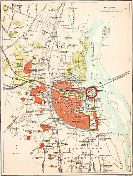 The red circle in this 1911 map of Shahjahanabad shows the braid of the Yamuna that flowed between the Red Fort and Salimgarh Fort. Map: Wikimedia Commons
The Salimgarh Fort was built by Salim Shah Suri, son of Sher Shah Suri, in 1546 on a riverine island. The Red Fort came up across what is now the Ring Road, in 1648, on the west bank of a braid of the Yamuna.
A painting in Reminiscences of Imperial Delhi — an album of some 130 paintings of views of Mughal and pre-Mughal monuments of Delhi — by Mazhar Ali Khan, commissioned by the colonial administrator Charles Metcalfe, shows the two forts connected by a bridge as the river flows between them. The bridge itself was built by the order of Bahadur Shah Zafar.
Shah Jahan’s original city had 14 gates, including the ‘water gate’, Khizri Darwaza, that opened directly to the river. Only Delhi Gate, Kashmere Gate, Ajmeri Gate, Turkman Gate, and the Nigambodh Gate survive. The rest, including the Lahori Darwaza, Kabuli Darwaza, Lal Darwaza, and Khizri Darwaza are long gone.
Shah Jahan first came to the completed Red Fort by way of the Yamuna, and entered his magnificent new home through its water gate.
“When it was inaugurated, Shah Jahan entered the Red Fort through the Khizri Darwaza. There was a Jashn-e-Mahtabi, and the qila was illuminated by candles. It is through this same gate that Bahadur Shah Zafar left on the night of September 17, 1857 after the fall of Delhi,” historian Rana Safvi said.
The Yamuna served many needs of the fort.
“The river was instrumental in choosing the location [of the fort]. Not only did it serve as a barrier, but water was required for the growing population. The weather is more clement where a river runs. There was a scheme of water channels inside the fort, the water for which also came from the Yamuna,” Safvi said.
Over the decades, the river changed course.
“The Yamuna was to be a defence for the Red Fort. The river began to move away, as rivers do, in the time of Muhammad Shah ‘Rangila’ (reign 1719-48),” writer and heritage enthusiast Sohail Hashmi said.
According to Hashmi, when the decision was taken to move the capital of the Raj to Delhi, the Coronation Park area was originally suggested as the location for the new buildings. “But in the monsoon of 1911, quite a lot of the Coronation Park-Kingsway Camp area, parts of Civil Lines and Model Town, were flooded,” he said.
“These areas were a part of the floodplains. That’s why the decision was taken to locate the capital at Raisina Hill,” Hashmi said.
Manu Bhatnagar, principal director of INTACH’s Natural Heritage Division, said changes in a river’s course in the northern part of the country is not unusual.
One of the reasons is believed to be the movement of the Indian Tectonic Plate.
“The Plate has been moving northward. That is the reason the Himalayas are rising. One reason for the course of the Yamuna moving eastwards too is believed to be this,” Bhatnagar said.
Also, it is more likely for a river to change course in the alluvial plains of North India.
“Alluvial terrain is soft and more amenable to changing river courses. If we look at the course of the Ganga between 1786 and now, there are places where it has changed its course by 34 km,” Bhatnagar said. “In Badaun (UP) the river has moved 10 km from where it used to be. At several places along the river, you will find ghats but no river. In fact, across the world, you can find bridges that were once built over a river, which later changed course,” he said.
Where a braid of the Yamuna flowed, there is the Ring Road now, Bhatnagar said. “The piers of both the bridge built by Bahadur Shah Zafar and the railway bridge that the British built later, have a streamlined shape. This was done to part the water to diminish the impact on the piers,” he said.