
 Weather Forecast Report, Cyclone Amphan LIVE: Bengal, Odisha on alert as deep depression intensifies into cyclonic storm, says IMD.
Cyclone Amphan, weather forecast Today Live updates: The deep depression over southeast Bay of Bengal and neighbourhood has rapidly intensified into a cyclonic storm ‘Amphan’ (pronounced as Um-pun), the India Meteorological Department (IMD) said in its latest bulletin on Saturday. “It lay centered over the same region at 1730 hrs IST of today (May 16) near latitude 10.9°N and longitude 86.3°E, about 1040 km south of Paradip (Odisha), 1200 km south-southwest of Digha (West Bengal) and 1300 km south-southwest of Khepupara (Bangladesh),” the IMD said in its bulletin issued at 8.30 pm.
The cyclone is very likely to intensify further into a severe cyclonic storm during next 12 hours and into a very severe cyclonic storm by 18th morning. It is very likely to move north-northwestwards initially till 17th May and then re-curve north-northeastwards across northwest Bay of Bengal towards West Bengal and adjoining North Odisha coasts during May 18 to 20. Fishermen are advised not to venture into south Bay of Bengal from May 16 to 17 to central Bay of Bengal from 17th to 18th and north Bay of Bengal during 19th to 20th. Light to moderate rainfall at most places with heavy falls at isolated places is very likely over Andaman and Nicobar Islands during next 12 hours.
According to a PTI report, the Odisha government has urged the Centre to temporarily suspend the running of ‘Shramik Special’ trains to the state’s coastal districts in view of the impending cyclonic storm. As many as 12 coastal districts – Gajapati, Ganjam, Puri, Khurda, Jajpur, Nayagarh, Balasore, Bhadrak, Kendrapara, Jagatsinghpur, Mayurbhanj and Cuttack have put on alert.
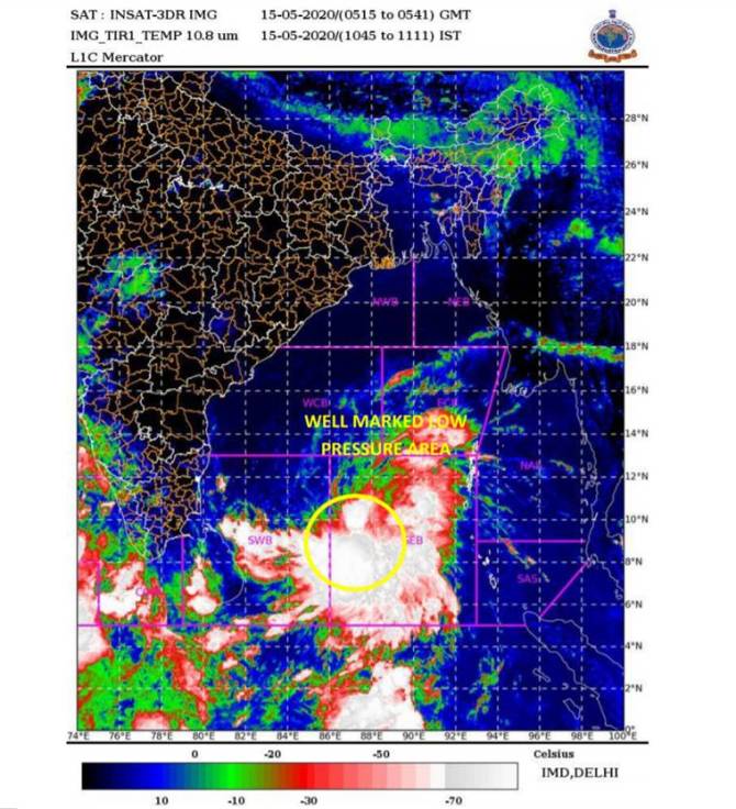 The low-pressure area over the southeast Bay of Bengal. (IMD)
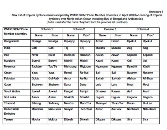

The India Meteorological Department (IMD) recently released a list of 169 names of future tropical cyclones that would emerge in the Bay of Bengal and the Arabian Sea.
Cyclones that form in every ocean basin across the world are named by the regional specialised meteorological centres (RSMCs) and Tropical Cyclone Warning Centres (TCWCs). There are six RSMCs in the world, including the India Meteorological Department (IMD), and five TCWCs.
As an RSMC, the IMD names the cyclones developing over the north Indian Ocean, including the Bay of Bengal and Arabian Sea, after following a standard procedure. The IMD is also mandated to issue advisories to 12 other countries in the region on the development of cyclones and storms.READ FULL EXPLAINED
The IMD, in its latest bulletin, has issued a moderate warning for coasts along West Bengal and North Odisha. 'It is very likely to intensify further into a severe cyclonic storm during the next 12 hours and into a very severe cyclonic storm by 18th morning. It is very likely to move north-northwestwards initially till May 17 and then re-curve north-northeastwards across northwest Bay of Bengal towards West Bengal and adjoining North Odisha coasts during 18-20 May'
A cyclonic storm brewing in the Bay of Bengal lay 1,220 km south-southwest of Digha in West Bengal on Saturday morning, and is likely to bring heavy to very heavy rain in the coastal districts of the state from May 19, the Met office said here.
The system is likely to intensify into a severe cyclonic storm by Sunday evening and move north-northwestwards till May 17, Regional Met Director G K Das said. It is very likely to recurve north-northeastwards thereafter towards the West Bengal coast during May 18 to 20, he said. Under its impact, the coastal districts of Gangetic West Bengal, including North and South 24 Parganas, Kolkata, East and West Midnapore, Howrah and Hooghly will experience heavy to very heavy rain on May 19 and 20, Das said.
Light to moderate rainfall at most places with heavy falls at isolated places in very likely over Andaman and Nicobar Islands during next 12 hours. Meanwhile, coastal Odisha is likely to experience light to moderate rainfall at many places with heavy falls at isolated places from 18th evening, heavy to very heavy to very heavy rainfall at a few places on 19th and isolated heavy rainfall over northeast Odisha on May 20. Coastal districts of Gangetic West Bengal are likely to experience light to moderate rainfall at many places with heavy falls at few places on 19th, heavy to very heavy falls at a few places with extremely heavy falls at isolated places over Gangetic West Bengal on 20th.
The deep depression over southeast Bay of Bengal and neighbourhood has rapidly intensified into a cyclonic storm ‘Amphan’ (pronounced as Um-pun), the India Meteorological Department said in its latest bulletin. “It lay centered over the same region at 1730 hrs IST of today (May 16) near latitude 10.9°N and longitude 86.3°E, about 1040 km south of Paradip (Odisha), 1200 km south-southwest of Digha (West Bengal) and 1300 km south-southwest of Khepupara (Bangladesh),” the IMD said in its bulletin issued at 8.30 pm.
Forecast track and intensity are given in the following table
The Odisha government urged the Centre to temporarily suspend running of 'Shramik Special' trains to the state's coastal districts in view of the impending cyclonic storm that is likely to intensify from Sunday, official said. The request was made by Chief Secretary A K Tripathy on Saturday during a video conference with Cabinet Secretary Rajiv Gauba. "We have urged the Centre to suspend running of Sharmik Special trains for 3-4 days as it may create problems for administration as well as the passengers amidst the cyclone," Special Relief Commissioner (SRC), P K Jena, told reporters. PTI
The National Crisis Management Committee (NCMC) on Saturday reviewed the preparedness for the impending cyclone, which is likely to hit Odisha and West Bengal coast, and directed immediate assistance to the two states. A meeting of NCMC, headed by Cabinet Secretary Rajiv Gauba, was held here to take stock of the preparation for the impending cyclone over the Bay of Bengal, an official statement said. The cabinet secretary took stock of the current situation and preparedness for rescue and relief operations and directed that immediate assistance, as required, be provided, it said. PTI
“Cyclone Amphan is very likely to move northwestwards initially till May 17 and then re-curve north-northeastwards towards northern Bay of Bengal between May 18-20,” the department said in its latest bulletin. (Source: IMD)
Though the IMD is yet to make an exact forecast about the landfall of the cyclone, the administration has braced for the impending situation and accordingly, focused on the northern coastal districts of Jagatsinghpur, Kendrapara, Bhadrak and Balasore, Special Relief Commissioner (SRC), P K Jena said. "If required, evacuation of people will be undertaken in view of the situation," he was quoted as saying by PTI.
The depression, which is around 1,250 km south of Digha in West Bengal and 1,330 km south-southwest of Khepupara in Bangladesh, is likely to intensify rapidly into a cyclonic storm by Saturday evening and then into a severe cyclonic storm during the subsequent 24 hours, Bhubaneswar Meteorological Centre Director H R Biswas said.
Meanwhile, scattered to widespread rain/thundershowers accompanied with lightning and gusty winds is expected over south peninsular India during the next 4-5 days along with isolated heavy rainfall activity over Kerala during the next 5 days, over south interior Karnataka from May 15-17 and over Coastal Karnataka and Lakshadweep on May 15 and 16. Northeastern states are likely to experience scattered to widespread rain over the next 5 days. From May 18, onwards, scattered rain/thundershowers are likely over Odisha Gangetic West Bengal.
The coastal districts of Gangetic West Bengal are also likely to experience light to moderate rainfall across many areas from May 19. Heavy to very heavy downpour is likely to occur at isolated places from May 20. Fishermen in the concerned areas have been advised from venturing into the sea between May 18 and 20.
Coastal Odisha is likely to experience light to moderate rainfall at several places and heavy downpour in a few isolation regions from Monday evening, the IMD said today.
Squally wind speed reaching 45 to 55 kmph gusting to 65 kmph is likely along and off Odisha coast from May 19, the IMD said.
The IMD recently released a list of 169 names of future tropical cyclones that would emerge in the Bay of Bengal and the Arabian Sea. Cyclones that form in every ocean basin across the world are named by the regional specialised meteorological centres (RSMCs) and Tropical Cyclone Warning Centres (TCWCs). There are six RSMCs in the world, including the India Meteorological Department (IMD), and five TCWCs. As an RSMC, the IMD names the cyclones developing over the north Indian Ocean, including the Bay of Bengal and Arabian Sea, after following a standard procedure. The IMD is also mandated to issue advisories to 12 other countries in the region on the development of cyclones and storms. To know more, click here.
The sea condition is also likely to be rough over south and adjoining central Bay of Bengal and Andaman Sea till May 16 afternoon. It will be high over southwest from today evening and very high from the same region from Sunday morning, the weather department said. The sea condition will become phenomenal over southern parts of central Bay of Bengal on May 18, over northern parts of central area of the sea on May 19 and over northern part on May 20, it added.
Here is a look at the movement of the cyclonic disturbance in the Bay of Bengal. (Source: IMD)
Odisha Special Relief Commissioner P K Jena said he reviewed the situation and the possible impact on the state with Chief Secretary Asit Tripathy. The situation will be managed properly as Odisha has vast experience in dealing with such situations in the past, the special relief commissioner said, adding, "We are well prepared to deal with any situation. However, the district administrations will have the double task to manage COVID-19 situation along with the possible cyclone."
Though the IMD is yet to give an exact forecast on the system, the weather department on Friday made it clear that the well-marked low pressure will take the shape of depression and intensify into a cyclonic storm later. "We cannot predict the trajectory of the system now as the depression is yet to be formed. However, it may have some impact on the districts located in the northern region of Odisha and southern parts of West Bengal. As a result, heavy rainfall is likely in coastal areas from May 19," Director General Mrutunjay Mohapatra was quoted as saying by PTI.
On Friday, Odisha made all arrangements for the possible cyclone by putting 12 coastal districts on alert and asking collectors to arrange for alternative shelter homes for people. Fishermen have also been advised not to venture into the south and the central Bay of Bengal from May 15. Those who are out at sea over these regions are advised to return to coasts.
In the revised Southwest monsoon calendar, the monsoon will cover the entire country one week in advance and begin its retreat two weeks later than the earlier dates. This was stated in a study to derive monsoon dates, a report of which was released on Friday by the India Meteorological Department (IMD).
The revision is done based on rainfall information gathered from about 2,500 weather stations, providing daily observations for the period 1961-2019 (onset) and 1971-2019 (withdrawal). Read more here
With the monsoon season coming amid the COVID-19 pandemic, the top officials of Gujarat government, Indian Meteorological Department (IMD) and armed forces held a meeting through video conference Friday to discuss pre-monsoon action plan, said an official release.
Chief Secretary Anil Mukim asked the officials to make the preparations while keeping in mind the guidelines issued by the central government in that regard in carrying out any possible relief and rescue operations, the release said. Read more here
India Meteorological Department has said that the Southwest monsoon this year would see a delayed onset over Kerala and hit the southern state only on June 5. Normally, the onset date over Kerala is June 1. However, since 2015, the monsoon has not made a timely arrival. Monsoon onsets during 2015, 2016 and 2019 took place sometime in the first week of June. In its first Long Range Forecast (LRF) issued last month, the Met department had forecast a normal monsoon during the June to September season. A revised calendar comprising monsoon onset and withdrawal dates over various parts of the country was also announced. These revised dates would be effective starting this season. However, onset over Kerala was retained as June 1.
In the midst of the fight against the COVID-19 pandemic, Odisha braced for a possible cyclone by putting 12 coastal districts on alert on Friday and asking collectors to arrange for alternative shelter homes for the people there, a top government official said.
A well-marked low-pressure over the Bay of Bengal is all set to intensify into a depression and a cyclonic storm. Odisha Special Relief Commissioner P K Jena said he reviewed the situation and the possible impact on the state with Chief Secretary Asit Tripathy. According to preliminary information from the India Meteorological Department (IMD) the possible depression will re-curve from its path to north-northeast direction and move in the Bay of Bengal, Jena said.
Odisha Special Relief Commissioner P K Jena said: "Plans have been made for pre-positioning of the ODRAF, NDRF and fire service personnel if the situation arises. They will rescue people likely to be affected by the probable calamity and clear roads if they get blocked."
Each Tropical Cyclone basin in the world has its own rotating list of names. For cyclones in the Bay of Bengal and the Arabian Sea, the naming system was agreed by eight member countries of a group called WMO/ESCAP and took effect in 2004. These countries submitted eight names each, which are arranged in an 8×8 table. After the 64 names are exhausted, the eight countries will propose fresh lists of names.
For cyclones from the Bay of Bengal and the Arabian Sea, these lists are not rotated every few years, as explained by the India Meteorological Department’s Regional Specialized Meteorological Centre (RSMC) for Tropical Cyclones over the Northern Indian System.
Chief Secretary Asit Tripathy has asked the Collectors in state to prepare for the worst irrespective of what the IMD predicts. "I know you are fighting the pandemic... Now we require people for the possible cyclone situation. Prepare for the worst... prepare for the ultimate eventuality," he said.
The southwest monsoon is likely to hit Kerala on June 5, a delay of four days as compared to its normal onset date, the India Meteorological Department said on Friday. The onset of monsoon over Kerala marks the commencement of the four-month-long rainfall season from June to September. According to the normal onset date, monsoon makes arrival in Kerala on June 1.
"The onset of southwest monsoon over Kerala this year is likely to be slightly delayed as compared to normal date of onset. The monsoon onset over Kerala this year is likely to be on June 5 with a model error of plus or minus 4 days," the IMD said.
"We cannot predict the trajectory of the system now as the depression is yet to be formed. However, it may have some impact on the districts located in the northern region of Odisha and southern parts of West Bengal. As a result, heavy rainfall is likely in coastal areas from May 19," IMD Director General Mrutunjay Mohapatra said.
Under the influence of the well-marked low-pressure area over the southeast Bay of Bengal, adverse weather is likely over the adjoining Andaman Sea along and off Andhra Pradesh, Odisha and West Bengal coast during the next 5-6 days, the India Meteorological Department has said.
Fishermen have also been advised not to venture into the south and the central Bay of Bengal from May 15. Those who are out at sea over these regions are advised to return to coasts.
Odisha has braced for a possible cyclone by putting 12 coastal districts on alert on Friday and asking collectors to arrange for alternative shelter homes for people, news agency PTI reported.
A well-marked low-pressure over the southeast Bay of Bengal is all set to intensify into a depression in the next 12 hours, the Indian Meteorological Department (IMD) said Friday. It also forecast that it will further intensify into a Cyclonic storm by the evening of May 16.