© The Indian Express Pvt Ltd

 NISAR satellite on July 18, 2025, at the Indian Space Research Organisation's Satish Dhawan Space Center in Sriharikota, Tirupati district, Andhra Pradesh, India. (Photo: AP)
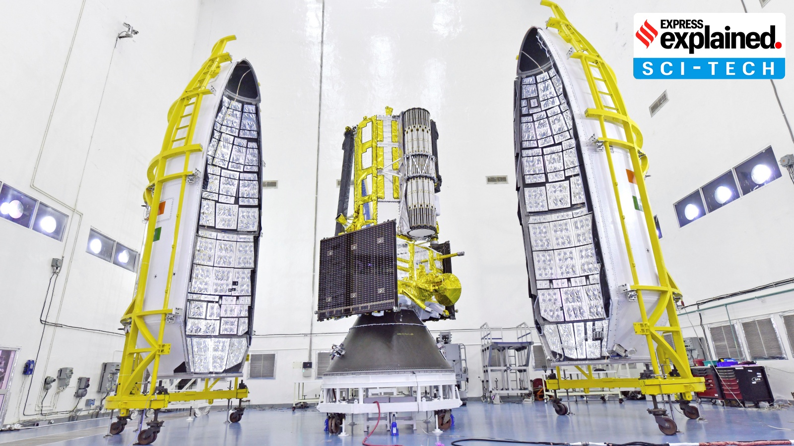
Earth observation satellites are fairly common these days, with countries routinely deploying them in space for a variety of purposes. But the satellite that the Indian Space Research Organisation (ISRO) is going to launch on Wednesday evening is anything but routine. It is a satellite that has been in the making for more than one and a half decades. And it is the first time that ISRO and its US counterpart, NASA (National Aeronautics and Space Administration), have jointly built a satellite, which is why it has got the name NISAR (NASA-ISRO Synthetic Aperture Radar).
NISAR is special for several other reasons. Once deployed, it will be the most powerful Earth observation satellite in space, producing data and high-resolution images that will facilitate research in a variety of fields. It is the first satellite to be mounted with two Synthetic Aperture Radars (SARs), operating in different frequency bands, a technological feat that has made it immensely powerful and useful. It also happens to be the most expensive satellite ever.
Double SARs
NISAR’s uniqueness is the two SARs that it is fitted with. Radars — the familiar large dish-shaped antennas — are instruments that send out signals in the non-visible spectrum of electromagnetic waves, typically microwaves or radio waves, and collect the signals that bounce back from objects. The returning signals are then analysed to glean a variety of information about the object, like its distance from the radar, its velocity if it is moving, and composition, texture or other properties of the object. In general, the larger the size of the dish antenna, the greater the amount of information collected from returning signals.
Imaging radars use the returning signals to create an image of the object. SARs are a special kind of imaging radar that are deployed in space where large dish-like radars, similar to those installed on the ground, cannot be sent. SARs make up for this limitation with sophisticated technologies and algorithms to mimic the power and resolution of large ground-based radars.
NISAR’s antenna of 12-metre diameter, for example, is capable of producing images whose resolution would be comparable to those produced by a simple ground-based antenna 20 km in diameter, according to information put out by NASA.
A number of SAR-mounted satellites are currently deployed in space. ISRO’s RISAT (Radar Imaging Satellites) series of satellites, which have now been renamed to the EOS series, carry SAR. Some of ISRO’s other Earth observation satellites, like Cartosat or Oceansat, do not use SAR.
Unprecedented imagery
The power of NISAR comes from two SARs, one operating in the L-band frequency and the other in the S-band. Together, they are designed to capture complementary sets of images for the same location at the same time, thereby providing such a detailed view of the Earth that has not been possible before. Both the L-band and S-band radars can see through clouds, smoke, rain or fog, thus getting an unfiltered view of the Earth across all weathers and through day and night.
Their different wavelengths then enable them to capture different kinds of details on the surface. The L-band SAR, which uses higher wavelength microwaves, can better penetrate tree cover or vegetation, and even sand or ice. It is, therefore, able to capture minute details of surface undulations, and can see through dense forest cover, for example, to map the ground below and measure tree trunk biomass, which is very useful for estimating carbon stock.
The S-band SAR, which has a shorter wavelength, is unable to go much deeper, but is good for capturing the larger features, such as crop fields or water bodies. It can observe crops like soybean, corn, sugarcane and provide information on their different growth and maturity stages. This observation will especially focus on India.
Whereas, the L-band SAR will help observe tall trees and thick forests, with observation focus on regions along the Western US, the Amazon rainforest, Antarctica, Greenland and northern Alaska. Working together, the S-band radar can get good details of tree canopy cover, while the L-band SAR can penetrate below to map what is hidden underneath. This gives a very comprehensive picture of the area being watched.
This kind of imagery is not possible by integrating data from S-band and L-band SARs on two separate satellites, for example. The satellites would not be looking at the same place simultaneously, and the changes that happen in between their observations would be missed. On NISAR, the two SARs are designed to work synchronously and complement each other. The satellite will generate 80 TB of data every day, which is three times more than any other existing Earth observation system.
Putting two SARs on the same satellite was a major engineering challenge, which was the main reason for NISAR taking a long time to get ready. The two radars require their specific hardware, and integrating their signal processing capabilities without one of them interfering with the other needed sophisticated engineering.
India-US collaboration
It also drove up the costs significantly. That is the reason why a collaboration between two leading space agencies made sense. The L-band SAR, the 12-metre antenna, and many other components and systems, including GPS control, have come from NASA, while ISRO has contributed the S-band SAR, the rocket and spacecraft and its sub-systems, and will carry out the launch. Both NASA and ISRO will handle the mission operations from their respective ground stations. In terms of total investment, NASA has contributed about $1.16 billion, while ISRO has pitched in with $90 million.
The concept for a NISAR-like mission emerged in 2007 when a US committee had recommended a space mission to study how changes in land, ice or vegetation cover were taking place. The mission was supposed to carry out surface deformation monitoring to facilitate studies of earthquakes, landslides and volcanoes, apart from making observations that will help the study of climate change, global carbon cycle, changes in vegetation, biomass and ice-cover.
NASA began working on the project in 2008. ISRO came into the picture four years later, when it identified science studies and applications that were complementary to the primary objective of the mission. NASA and ISRO had collaborated earlier — there was a NASA payload on ISRO’s Chandrayaan-1 — but never jointly developed or executed a space mission. The two agencies signed a deal on NISAR in 2014, and have been engaged in developing this mission since then.
The NISAR launch comes at a time when the two countries have stepped into a more strategic partnership on space. India has signed on to the Artemis Accords, a sort of US-led alliance on space exploration that is closely linked to NASA’s Artemis programme seeking a return of humans to the Moon. NASA and ISRO have also worked out a strategic framework for human spaceflight cooperation, one of the first outcomes of which was the participation of Shubhansu Shukla in the NASA-facilitated Axiom-4 private mission to the International Space Station.