Journalism of Courage

 Goa has the highest tree cover as a percentage of geographical area, at 8.73%, followed by Delhi and Kerala, both at 7.62%. (Express File Photo)
The Economic Survey of Delhi 2018-19, released last week, states that the capital’s forest cover has increased from 12.72% of its geographical area in 2015 to 12.97% in 2017, while its tree cover has increased from 7.48% to 7.62%.
The Ministry of Environment, Forest & Climate Change defines ‘forest cover’ in India as “all lands, more than one hectare in area with a tree canopy density of more than 10%”, and ‘tree cover’ as “tree patches outside recorded forest areas exclusive of forest cover and less than the minimum mappable area of one hectare”.
Between these two is a third measure, called ‘trees outside forest’, or TOF.
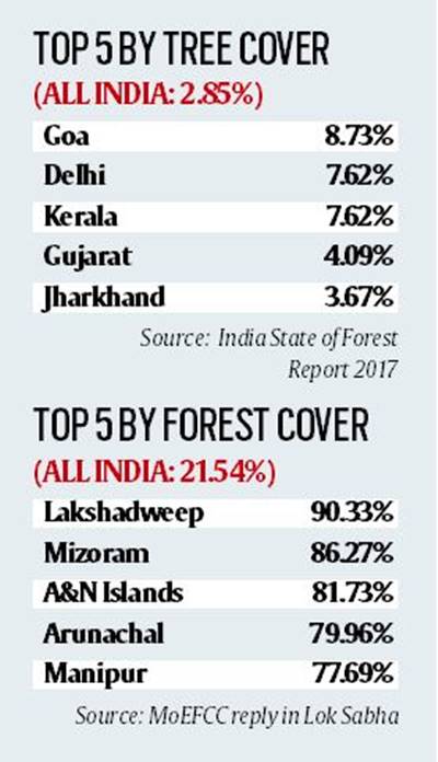
The ‘India State of Forest Report 2017’ defines TOF as “trees existing outside the recorded forest area in the form of block, linear & scattered size of patches”.
Since tree cover measures only non-forest patches that are less than 1 hectare, it is only a part of TOF.
The India Report, as well as the Delhi Survey, cite state-wise figures, which show that Goa has the highest tree cover as a percentage of geographical area, at 8.73%, followed by Delhi and Kerala, both at 7.62%.
Forest cover highs are in Lakshadweep (90.33%) and Mizoram (86.27%). India has 93,815 hectares, or 2.85% of its area, under tree cover, and 7.08 lakh ha (21.54%) under forest cover.

The Enforcement Directorate (ED) on Thursday conducted searches at 10 premises associated with the election management company I-PAC in Kolkata and Delhi. The company, founded by election-strategist-turned-politician Prashant Kishor, is currently managing election campaigns of the Mamata Banerjee-led Trinamool Congress. West Bengal will go to elections this year.