


© IE Online Media Services Pvt Ltd
Tags:
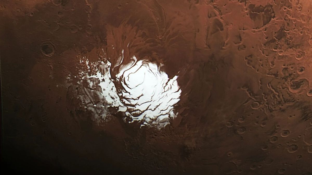
Nasa’s Mars Reconnaissance Orbiter (MRO) has investigated a feature beneath the ice at Mars’s south pole, which sparked new inquiries about its composition. A study utilising an advanced radar technique concluded that this area, initially thought to be a subterranean lake, is more likely to be composed of rock and dust. The initial discovery in 2018 had fuelled excitement among scientists due to the potential relationship between water and the possibility of life in the solar system.
The MRO, managed by NASA’s Jet Propulsion Laboratory, is essential to the Mars exploration programme. MRO’s operations are supported by Lockheed Martin Space, which built the orbiter, while the radar analysis instrument SHARAD was supplied by the Italian Space Agency.

Before this advancement, Morgan, Putzig, and their collaborators had made several unsuccessful attempts to observe the suspected lake area. Collaboration with NASA’s Jet Propulsion Laboratory resulted in the development of this large roll capability, which required rigorous planning to ensure the spacecraft’s safety, addressing the radar’s visibility issues. Engineers from Lockheed Martin Space played a key role in crafting the commands essential for this 120-degree roll manoeuvre to focus SHARAD’s signal towards the surface more effectively.
To optimise their observations, the MRO team executed a special manoeuvre involving a 120-degree roll of the spacecraft, which significantly enhanced the SHARAD radar’s ability to penetrate deep underground and deliver clearer images of the subsurface. This innovative approach has proved effective, leading scientists to consider applying it to other previously monitored sites that may harbour buried ice.
On May 26, the SHARAD instrument conducted a significant manoeuvre, known as a very large roll, to analyse a targeted area that spans approximately 12.5 miles (20 km) beneath a thick layer of water ice, approximately 1 mile (1,500 m) deep.
Radar signals reflecting off subsurface materials vary in strength, with most materials causing the signals to weaken or be absorbed. However, water is an exception, as it creates a highly reflective surface that sends back a strong radar signal, akin to how a flashlight illuminates a mirror. This reflective characteristic was initially detected in 2018 by the MARSIS (Mars Advanced Radar for Subsurface and Ionospheric Sounding) instrument on the European Space Agency’s Mars Express orbiter, leading scientists to hypothesise the presence of a briny lake beneath the ice, as high salinity can lower the freezing point of water.
For nearly two decades, the SHARAD team had been monitoring this particular area without observing signals from those depths, as noted by Putzig. However, this recent large roll allowed for a deeper observation, resulting in SHARAD capturing a faint signal, in contrast to the bright signal previously noted by MARSIS.
Additionally, another very large roll observation in a nearby area yielded no signal, implying that a unique factor may be responsible for the unusual radar readings at the exact site where MARSIS detected a signal. Morgan emphasised the impact of the lake hypothesis as a catalyst for creative scientific inquiry, although the new data present challenges to maintaining the theory of a liquid water lake, underscoring the ongoing nature of scientific exploration and debate on Mars’ subsurface features.
Mars’s south pole features an ice cap situated over heavily cratered terrain, with radar imaging revealing numerous peaks and valleys beneath the ice. Morgan and Putzig speculate that the bright signal detected by the MARSIS instrument may indicate a rare smooth area, potentially an ancient lava flow. The scientists are enthusiastic about employing the very large roll technique to further investigate other intriguing Martian regions, such as Medusae Fossae—an extensive geological formation located at Mars’ equator, which shows minimal radar return.
There are competing theories regarding Medusae Fossae’s composition, with some scientists proposing that it consists of volcanic ash layers, while others suggest that these layers could contain substantial amounts of ice. The presence of ice is significant. Putzig notes that if ice exists, it hints at abundant water resources near the equator, an ideal location for future human exploration due to increased sunlight exposure, warmer temperatures, and suitability for human habitation and operations.


