Journalism of Courage


Gujarat Chief Minister Narendra Modi may take pride in developmental strides taken by Gujarat. But its haphazard character seem to have caused this year8217;s devastating flood. And Modi too admits this candidly. Experts too have echoed the same.
Today, he told reporters that the government has woken up and hired a Canadian imaging satellite to identify the trouble spots so that developmental and flood preventive activities could be planned for next 100 years.
8216;8216;In the last few years the topography of the state has changed because of large-scale development works8212;laying of canals and railway tracks, construction of new colonies. The flash floods, we believe, were caused by changes in the topography,8217;8217; Modi said after a meeting with voluntary groups.
Satellite images, he said, would be used for determining the flow of water, locating obstructions and water-logged regions, and drawing up development plans that will prevent such floods.
A government official said the satellite was equipped to take pictures through thick clouds and has already been transmitting them for the last five days.
Experts said although central Gujarat received heavy rainfall this year, the magnitude of flood was unprecedented. They hadn8217;t expected large areas of the Vadodara, Anand and Kheda districts to be marooned, or the expressway and National Highway-8 to be left unmotorable.
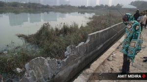
After heavy rain left western parts of Ahmedabad flooded last week, eminent architect B.V. Doshi had said it was the consequence of bad planning that disregarded topography.
In Vadodara, where the Vishwamitri overflowed and cut off eastern and western parts of the city, councillors and municipal authorities blamed the floods on new colonies that block the natural flow of water.
Officials who were on air force choppers flying sorties to the flooded Anand and Kheda districts, said the worst-affected colonies were those that had come up where ponds, lakes, or natural watercourses existed before.
Town planners pointed out that in Vadodara, several colonies have come up where the Sukhi rivers used to flow.
8216;8216;Look at how even the Vishwamitri8212; which has never overflowed in the last 50 years8212; has caused so much havoc,8217;8217; was how Modi put it.

Anil Ravipudi’s action thriller Maha ShankaraVaraprasad Garu, starring Chiranjeevi and Nayanthara, has emerged as the winner among this year’s Sakranthi releases across the Telugu and Tamil film industries. The film’s unconventional release on a Monday, two days before the mid-week festival, has worked in its favour as it crossed the Rs 165 crore mark at the domestic box office.