
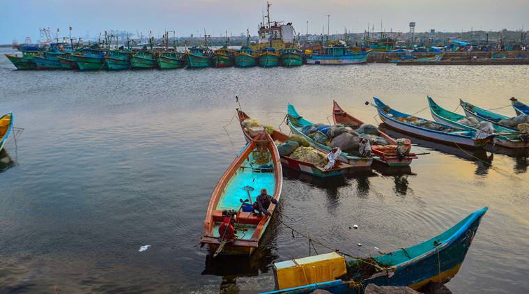
 Cyclone Gaja HIGHLIGHTS: Fishing operations were suspended along the coasts of north Tamil Nadu, Puducherry and adjoining Andhra Pradesh after a warning was issued to fishermen to not venture into the deep sea. (PTI photo)
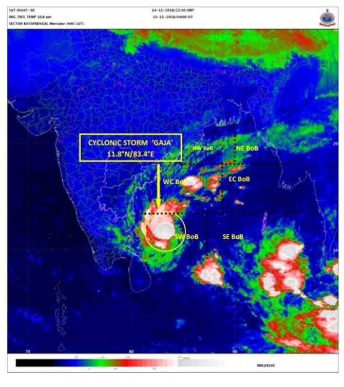
According to the India Meteorological Department’s latest release, cyclonic storm ‘Gaja’ is set to make landfall between Cuddalore and Pamban on Thursday evening bringing heavy rainfall to Tamil Nadu. ‘Gaja’, named by Sri Lanka, was about 470 km northeast off the coast of Chennai on Wednesday and is likely to cross the coast between Pamban and Cuddalore on Thursday evening or night with a wind speed gusting up to 100 kmph, the Met department said.
Fishing operations were suspended along the coasts of north Tamil Nadu, Puducherry and adjoining Andhra Pradesh after a warning was issued to fishermen to not venture into the deep sea.
Meanwhile, all schools remained closed in Thanjavur, Tiruvarur, Pudukottai, Nagapattinam, Cuddalore and Ramanathapuram districts in Tamil Nadu Thursday as a precautionary measure. Puducherry has declared a holiday for educational institutes as well. Two Naval ships, Ranvir and Khanjar, with additional divers, doctors, inflatable rubber boats, integral helicopters and relief material on board are on standby for rescue and relief operations, reported PTI.
 (Source: IMD)
"Two Indian Naval ships -- Ranvir and Khanjar -- are standing by to proceed to the most affected areas to undertake humanitarian aid and distress relief," a Navy official was quoted saying by PTI. Helicopters, Dornier aircraft and one P8I aircraft are on standby to undertake reconnaissance, rescue and casualty evacuation, the official added.
The Indian Navy was Wednesday put on high alert in view of cyclone Gaja approaching the coast of south Tamil Nadu and Puducherry, Officials were quoted as saying by PTI.
Navy officials said the Eastern Naval Command (ENC) has assumed a high degree of readiness to render necessary humanitarian assistance as the cyclone is poised to cross the coast of the two states on Thursday evening.
The cyclonic storm 'Gaja' is set to make landfall between Cuddalore and Pamban on Thursday evening bringing heavy rainfall to Tamil Nadu, news agency PTI reported.
The weather department has recommended complete suspension of fishing operations along the coasts of north Tamil Nadu, Puducherry and adjoining Andhra Pradesh for November 14 and 15. A warning has been issued for the fishermen to not venture into the deep sea. Read here
Cyclonic storm 'Gaja' is likely to intensify into a severe cyclonic storm in the next 12 hours India Meteorological Department (IMD) said in it's latest release. The depression which lay over west-central, east-central and south Bay of Bengal is projected to be moving west-southwards about 520 km east of Chennai. The weather department has suggested a total suspension of fishing operations along the coasts of north Tamil Nadu, Puducherry and adjoining Andhra Pradesh for November 14 and 15. A warning has been issued for the fishermen to not venture into deep sea.
Puducherry Chief Minister V Narayanasamy Wednesday held a review meeting with officials of various departments at Thirunallar in Karaikal district and
took stock of the preparedness as cyclone Gaja is likely to hit the coastal district tomorrow. Twenty two cyclone shelters have been kept in readiness
to accommodate people, he said adding that a24 hour control room was functioning at the Collectorate. Schools and colleges have been declared holiday in the district on Thursday.
All private and government schools in Cuddalore will remain closed on November 15 as cyclonic storm 'Gaja' is likely to get 'severe', District Collector, Cuddalore told ANI.
Authorities have stepped up relief operations in Tamil Nadu as Cyclone 'Gaja' is expected to make a landfall between Paamban and Cuddalore on November 14. 20,000 families residing in the 'danger zone' near the coastline will be shifted to the relief camps, reported ANI
Cyclonic storm 'Gaja' is likely to make landfall tomorrow afternoon. We have formed 19 inter-departmental zonal teams and made arrangements to evacuate people living in the coastal areas to relief centres, Collector and District Magistrate of Cuddalore District Tamil Nadu has said.
The IMD, in its latest bulletin, has said a severe cyclonic storm is likely on November 14 in Tamil Nadu and Puducherry. Heavy rainfalls are also likely to commence over north coastal Tamil Nadu and Puducherry from November 14 evening.
The 27-hour countdown began Tuesday for the launch of India's latest communication satellite GSAT-29 onboard the second developmental flight GSLV-MkII D2 from the spaceport of Sriharikota Wednesday evening, subject to weather conditions, the ISRO said. Though cyclone "Gaja", earlier forecast to cross the coast between Chennai and Sriharikota, has changed course, the Indian Space Research Organisation said the launch slated for 5.08 pm was subject to the weather and it may go for a postponement in case of non-conducive conditions.
Chief Minister V Narayanasamy chaired a review meeting with officials of various departments to ascertain the preparedness. He said two teams of the National Disaster Response Force (NDRF) have arrived here and they would be positioned here and Karaikal near Nagapattinam in Tamil Nadu. Narayanasamy said he had directed all the departments to deploy manpower adequately and also keep ready equipment needed to pump out water from low lying areas as rainfall was expected to be intense in Puducherry and Karaikal under the impact of the cyclone. (PTI)
Puducherry government Tuesday put its machinery on full alert to meet the impact of cyclone 'Gaja' which is expected to cross the neighbouring Tamil Nadu coast between Cuddalore and Pamban.
Meanwhile, countdown has begun for the launch of India's latest communication satellite, GSAT-29. Though cyclone "Gaja", earlier forecast to cross the coast between Chennai and Sriharikota, has changed course, the Indian Space Research Organisation said the launch slated for 5.08 pm was subject to the weather and it may postpone it in case of non-conducive conditions.
On and off rains will continue till November 18 and thereafter rains will become very less, and only isolated rains may continue. At present Kerala is the only state in south peninsula which has received normal rains with 11% deficiency. However, by the end of this week, there are expectations for Kerala’s rain deficiency to come to some extent.
According to Skymet, off light to moderate rains to continue over southern parts of Kerala till November 15. The intensity of rains will increase over the state from November 16 and many parts of Kerala will receive light to moderate rains, but the intensity will be more over Thiruvananthapuram district. Few southern parts of Kerala recorded rainfall activity. In the last 24 hours from 08:30 am on Monday, Punalur recorded 29.4 mm of rain followed by Alappuzha 11.1 mm, Kayamkulam 6.6 mm, Vaikom 6.0 mm, Nedumangad 5.6 mm and Aryankavu 3.0 mm.
The Tamil Nadu government has put its machinery on alert and kept around 31,000 rescue personnel on stand-by. Neighbouring Puducherry was also alerted and precautionary steps were being taken to meet the situation. The National and State Disaster Response Force personnel have been deployed while vigil has been proposed in coastal districts. In Pamban, Ramanathapuram district authorities are on an alert and the Collector advised people living in low-lying areas to move to safer places. Fishermen in Pamban were asked to shift their boats to the 'Chinna Palam' area.
The gale would gradually sweep at 90-100 kmph and then reach 110 kmph over southwest and adjoining west-central and the southeast Bay of Bengal from November 14, it said. Sea was expected to be rough to very rough along the coast of Tamil Nadu and south Andhra Pradesh and Puducherry from the morning of November 14, the bulletin said. The waves were likely to rise to about one metre and inundate low-lying areas of Nagapattinam, Thanjavur, Pudukkottai and Ramanathapuram districts of Tamil Nadu and Karaikal at the time of landfall.
Heavy rainfall may occur in north coastal Tamil Nadu and adjoining districts of south coastal Tamil Nadu and Andhra Pradesh from the evening of November 14, it said. Winds may reach a speed of 70-80 kmph and touch 90 kmph over west-central and adjoining east-central and the south Bay of Bengal, the bulletin said. The gale would gradually sweep at 90-100 kmph and then reach 110 kmph over southwest and adjoining west-central and the southeast Bay of Bengal from November 14, the bulletin said.
A bulletin from the department said 'Gaja' was likely to move west-southwestwards and intensify further into a severe cyclonic storm during the next 24 hours. "While moving west-southwestwards, it is likely to weaken gradually and cross Tamil Nadu coast between Pamban and Cuddalore as a cyclonic storm in the afternoon of November 15," the bulletin said. (PTI)
Extremely heavy falls (≥ 20 cm) at isolated places is likely over Cuddalore, Nagappattinam, Tiruvarur, Thanjavur, Pudukkottai, Tuticorin and Ramanathapuram districts on November 15, the IMD has said in the latest bulletin.
Cyclone 'Gaja' is very likely to intensify further into a Severe Cyclonic Storm during the next 24 hours and maintain the intensity during the subsequent 24 hours. It is very likely to move west-southwestwards. While moving west-southwestwards, it is likely to weaken gradually on November 15, said the IMD.
With the onset of an intensified cyclonic storm, the National Disaster Management Authority (NDMA) has issued a list of Do's and Don'ts for before, during and after the storm.
Rainfall at most places with heavy falls at isolated places very likely to commence over north coastal Tamil Nadu and adjoining districts of south Tamil
Nadu from 14th November evening.
Then IMD has warned of major damage to thatched huts/houses around the affected areas. Roof tops may blow off and unattached metal sheets
may fly, it has said, predicting damage to power and communication lines.
Tamil Nadu Chief Minister K Palaniswami chaired a high-level meeting on Monday with top officials to review the preparedness in the wake of the storm and forecast of heavy rainfall. Across the state, a total of 4,399 locations have been identified as vulnerable and teams have been deployed for rescue.
Fishermen are advised not to venture into central parts of south and central Bay of Bengal on 13th and into southwest and adjoining westcentral Bay of Bengal during 13-15th November, the IMD said in its latest bulletin.
Storm surge of height of about 1.0 meter is very likely to inundate low lying areas of Nagappattinam, Thanjavur, Pudukkottai and Ramanathapuram districts of Tamil Nadu and Karaikal district of Puducherry at the time of landfall.
Cyclonic storm Gaja will cross Tamil Nadu coast between Cuddalore and Pamban on Nov 15, bringing heavy rainfall coupled with gale wind, the Met office
said Monday as the state government put its machinery on alert and kept on standby 30,500 rescue personnel.
The India Meteorological Department in its latest press release advised the fishermen to not venture into central parts of south and central Bay of Bengalon 12th and 13th and into southwest & adjoining west central Bay of Bengal during 13-15th November.
Storm surge of height of about 1.0 meter above astronomical tide is very likely to inundate low lying areas of Nagapattinam, Thanjavur, Pudukkottai and Ramanathapuram districts of Tamil Nadu and Karaikal district of Puducherry at the time of landfall.
Puducherry Revenue and Industries Minister M. Shahjahan said the union territory has been put on high alert. Services of NDRF personnel will be requisitioned if warranted, he said after a review meeting with top officials, PTI reported.
The Cyclonic storm ‘Gaja’ over west central and adjoining Eastcentral & Southeast Bay of Bengal moved southeastwards with a speed of 09 kmph during past 06 hours and lay centred at 1730 hrs IST of the 12th November 2018 over Southeast and adjoining Central & Southwest Bay of Bengal near latitude 12.6°N and longitude 87.3°E, about 760 km east-southeast of Chennai (Tamil Nadu) and 830 km east-northeast of Nagapattinam (Tamil Nadu), the latest press release by IMD stated.
It is very likely to move west-southwestwards and intensify further into a Severe Cyclonic Storm during next 24 hours and maintain the intensity during the subsequent 24 hours. Thereafter, while moving west-southwestwards, it is likely to weaken gradually and cross Tamil Nadu coast between Cuddalore and Pamban as a Cyclonic Storm during 15th November forenoon, the release added.
IMD will issue the next bulletin at 11:30 pm.
Citing the IMD forecast of heavy rains, the Central Water Commission issued an advisory to Tamil Nadu and Kerala authorities to maintain strict vigil at various dams which come under the "cyclone field" and are already 80 per cent to 91 per cent full, PTI reported.
Tamil Nadu Revenue Minister R B Udaya Kumar said 30,500 rescue personnel were on standby while arrangements had been made for food and shelter at relief centres for those in low lying areas, PTI reported.
Across the state, a total of 4,399 locations have been identified as vulnerable and teams have been deployed for rescue, he added.
Cyclone Gaja is expected to weaken gradually before crossing the coast of Tamil Nadu around forenoon on November 15 between Cuddalore and Nagapattinam, Skymet said.
IMD predicts Heavy rain at isolated places over South Coastal Andhra Pradesh on 14 November.
Scattered heavy to very heavy with isolated extremely heavy rain is likely to occur at most places over Tamilnadu and Puducherry on 15 November. Heavy rainfall is also predicted at isolated places over Kerala, Rayalaseema and South Coastal Andhra Pradesh by IMD.
Cyclonic storm 'Gaja' now lies at about 820 km east northeast of Nagapattinam. It is expected to cross between Chennai and Nagapattinam during forenoon on 15th November. Sea will be very rough, fishermen are advised not to venture in the sea till 15th November: Director IMD Chennai
Fishermen who are out at sea areas in South Andhra, North Tamil Nadu and South Tamil Nadu are advised to return to the coast, in a warning by the IMD.
Sea condition is very likely to be brought to very rough along and off South-Andhra Pradesh coast from November 13 evening. Those who are out at sea areas are advised to return to the coast: IMD warning
The deep depression over Southeast and adjoining central bay of Bengal moved West-Northwestwards and lay centered at night of November 10, at about 1120 km East-Southeast of Nellore(Andhra Pradesh). It is very likely to intensify into a cyclonic storm during next 12 hours.
Fishermen are advised not to venture into central part of south and central Bay of Bengal on 12th and 13th and into southwest and adjoining westcentral Bay of Bengal during 13-15th November, says IMD.
Gaja will be the second cyclone to hit the coastal area in a month after Cyclone Titli wreaked havoc in Odisha and Andhra Pradesh on October 11, killing a total of 70 people.
Rainfall at many places with heavy rainfall at isolated places likely over Andaman Islands on Monday and decrease thereafter, the IMD said, adding that heavy falls are very likely to commence over north coastal Tamil Nadu and adjoining south coastal Andhra Pradesh from evening of 14th November.