Journalism of Courage
Premium
This is an archive article published on August 21, 2023
Living on the edge: How reckless habitation on hilly areas in Mumbai make them prone to landslides
Standing several risks, working class residents continue living in these areas, mainly because they have nowhere else to go in the ‘expensive city’.

 According to the state disaster cell’s official figures, nearly 290 people died in landslide-related incidents in Mumbai between 1990 and 2021. (Express Photo by Amit Chakravarty)
Listen to this article
Living on the edge: How reckless habitation on hilly areas in Mumbai make them prone to landslides
x
00:00
The July 19 landslide in Irshalwadi of Raigad district that claimed 84 lives in July became a stark reminder of the ecological threats in the Western Ghats. However, Mumbai is not very different as hills and ridges where stone quarries were once functional make the city susceptible to landslide-related incidents every monsoon.
While no major catastrophic incident has been reported in the past two years, in 2021, 32 people lost their lives in a series of landslides in Chembur and Vikhroli in the suburbs.
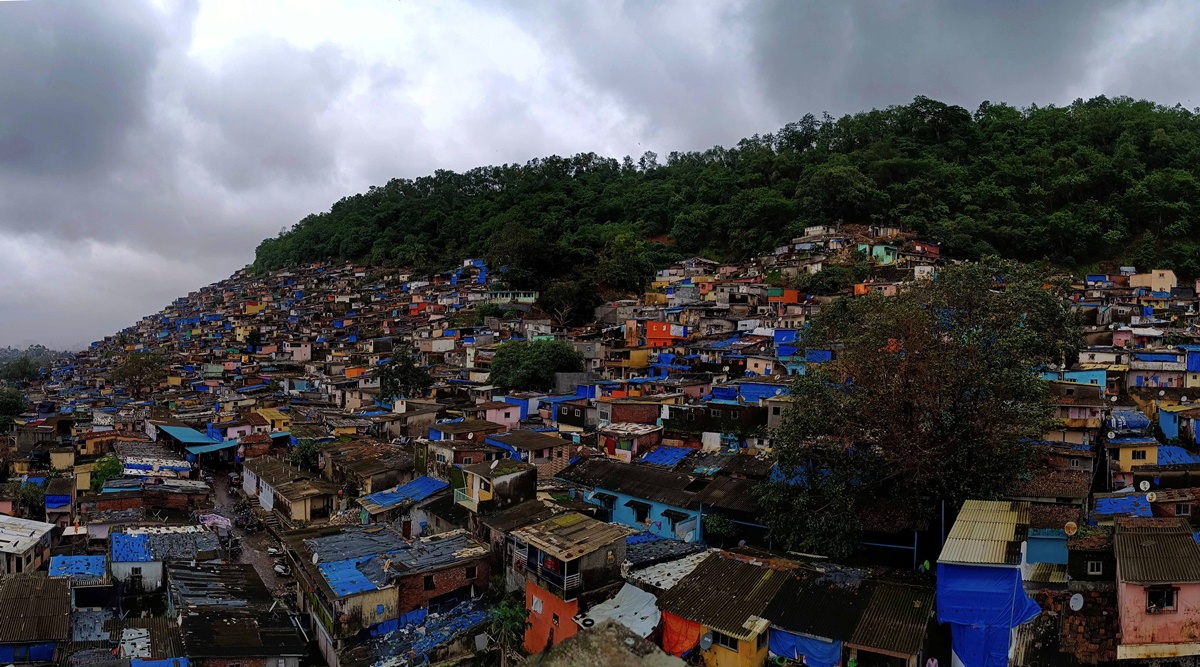
According to the state disaster cell’s official figures, nearly 290 people died in landslide-related incidents in Mumbai between 1990 and 2021. At present, nearly one lakh people live in these high-risk landslide prone areas. There are 299 landslide-prone areas in Mumbai and these places include hillocks and ridges with varying heights between 150 and 200 metres.
Between 2017 and 2018, the Geological Survey of India (GSI), carried out a risk-assessment study of Mumbai’s landslide prone locations, which has human habitation in the slopes, following which, 45 such spots were declared highly sensitive. Most of these spots are located in the regions of Ghatkopar, Vikhroli, Bhandup and Mulund in the eastern suburbs.
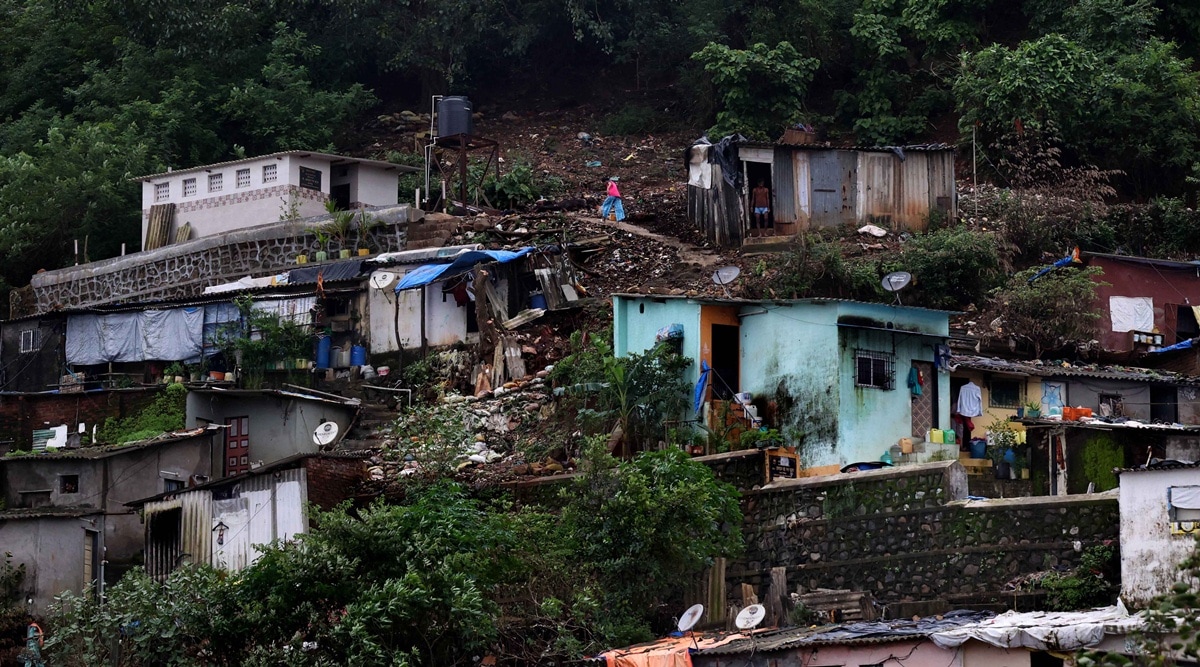 Housing units stand packed on the steep slopes at Vikhroli Park Site. (Express photo by Amit Chakravarty)
The slopes of these hills consist of informal settlements inhabited by Lower Income Groups (LIG) and members from marginalised communities.
The GSI, in its 435-page report, recommended framing of a land-use and hill-area development policy for Mumbai, however, nearly five years since, policies are yet to be chalked out.
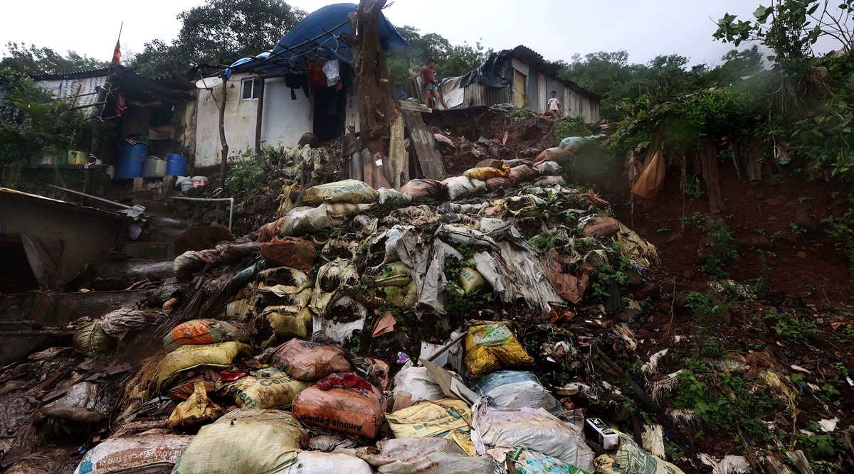
As a pre-emptive measure, the authorities built retaining walls in some of the vulnerable locations, but the long-term efficacy of the walls is being questioned by experts. In many cases, the walls are also encroached upon by slum-dwellers.
Most of these land parcels on which the hillocks stand belong to the district collector’s office, while some belong to the Mumbai Housing and Area Dev-elopment Authority (MHADA), though the Brihanmumbai Municipal Corporation (BMC) is the official planning authority. Multiple stakeholders means passing the buck when it comes to accountability.

Packed hills
Story continues below this ad
Rahul Nagar with 11 societies at Vikhroli Park Site is one of the most vulnerable spots prone to landslides in Mumbai. The housing units stand packed on the embankments of the steep slopes. The foundation of these houses is made by cutting the backslope of the hills, which leaves hardly any space between the hills and the settlement zone.
The 125-square-foot houses have cement walls and asbestos roof. In some slopes, there are double-storeyed housing units. The steep slopes are concretised for pathways wide enough for two pedestrians and the path becomes extremely slippery during monsoon, posing an additional threat to the residents. There is no conventional drainage system inside the settlements as sewage water is allowed to flow freely from the top.
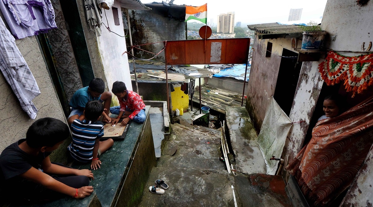
Vehicles cannot travel through the slopes and the residents have to ascend and descend at least 150 metres multiple times every day.
Bhima Laxman Kamble (49), has been staying in Rahul Nagar’s Shanti Doot Society since 2006. A contractual daily wage worker, Kamble stays with his wife and three children. His father moved to Rahul Nagar in 1973, from Latur to work as a daily wage worker in a stone quarry in the hills.
Story continues below this ad
“In the 1970s, construction work was going on everywhere as the city was growing. My father, along with other labourers settled in the hills as affording a house was very expensive,” says Kamble.
 Housing units stand packed on the steep slopes at Vikhroli Park Site. (Express photo by Amit Chakravarty)
Rohidas Namdeo (67), a retired school teacher, is living in Rahul Nagar, with his family since 1986. Namdeo, a local community leader, says that in the 1970s, the area had only 35 families.
“Those who settled here initially hailed from the interior parts of Maharashtra. In the 1990s, when the real estate boom took place, almost all the daily wage workers in the city were living in Rahul Nagar,” says Namdeo.
Local residents say that during monsoon, rocks and stones often come down rolling from the hilltop. While no severe accident was reported this year, many properties were damaged.
Story continues below this ad
Manohar Khedekar (41), who is living in Sahara Society in Vikhroli Parksite since 1991, says that residents who are located in the top are more vulnerable than those living in the foothills.
 Housing units stand packed on the steep slopes at Vikhroli Park Site. (Express photo by Amit Chakravarty)
“Whenever there is a landslide, rocks start rolling down and the houses higher on the ridge take most of the impact. When the rocks come down, the velocity decreases and the impact is reduced,” says Khedekar. “The soil also gets loose and during rain, tree collapse incidents are regular when our properties get damaged,” he adds.
In 2018, the authorities created a retaining wall. However, the wall has now been encroached upon with shanties erected on it. Certain parts of the wall are also damaged.
Stones that collapse from the top often damage the wall. In 2017, a five-month-old girl died after a stone crushed the shanti she was living in. “I have been here for 35 years and whenever there is heavy rain, we stay awake at night as we don’t know when something would collapse on us. Rainwater would flow directly through the ridges as there is no proper drainage or sewage network,” said Mira Tiwari, a resident of Shiv Garjana Society in Ghatkopar, which is on the list of sensitive zones in Mumbai.
Story continues below this ad
The residents are also concerned as trees on top of the ridge are cut on a regular basis. “New slums are set up every year… Unless the administration intervenes, we cannot legally prevent them from settling down,” said Tiwari. However, despite the risk involved, the residents say that they would continue to stay here, since there is no other option for them.
“There is no basic amenity on the hills and if someone is unwell, we will have to go down 200 metres to consult a doctor. Children also go down for school… We don’t have any other option but to continue to live here, as housing in Mumbai is very expensive,” said Gajanan Rao, another resident who is living here since the 1990s. Residents say that till 2017, there was no water supply on the hilltop and women would carry water up.
City and landslides
After the independence, Mumbai saw a huge influx of people from various parts of the country, following which the boundary of the city extended from the island city in the south to the suburbs in the north.
Prakash Gajbhiye, Director, Geological Survey of India (GSI), Pune who along with senior geologist JN Hindayar, carried out the vulnerability assessment of landslide-prone areas in Mumbai during 2017-18, says that these hills in the suburbs were a source of building material. The GSI carried out the vulnerability assessment test on BMC’s request.
Story continues below this ad
“After 1950s, Mumbai saw rapid industrialisation and development when people wo-uld extract stones and aggregates through mining in the hills, leaving depressions and voids over there, where people would eventually go and settle,” Gajbhiye told The Indian Express.
Living on the edge: How reckless habitation on the hilly areas in #Mumbai make them susceptible to landslide-related incidents
Pratip Acharya (@_iampratip) reports: https://t.co/egnQwr1Juz
📹 Amit Chakravarty (@Amit_Photowalla) pic.twitter.com/vPXIt8PqCb
— The Indian Express (@IndianExpress) August 21, 2023
“Most of the mining work during that era was carried out through blasting methods that damaged the hills… the blast also makes the surface of the hills hollow from inside. During monsoon, water starts penetrating through the hollow area and if there is heavy rain for 3-4 days, the situation worsen and landslides take place,” he said.
According to Gajbhiye, Mumbai is witnessing a change in its rainfall pattern, which is a triggering factor behind landslide incidents. Earlier, the city would record a uniform proportion of rain, while for the past few years, the city is recording very heavy rainfall within short periods.
He says that while it may appear that a landslide happens all of a sudden, it actually takes a lot of time for the situation to build up and prepare a slope for failure. “Factors like deforestation, blasting and haphazard cutting of hill slopes are known to be the aggravating factors for a landslide… Rainfall is more likely to trigger a landslide in deformed and unprotected cut slopes, which is a result of man-made activities…,” says Gajbhiye.
Land-use policy
In the 435-page risk assessment report, the GSI recommended the formulation of a land-use policy, specifically for the hilly areas of Mumbai. “For the planning purpose, our recommendations to the state government were to frame a Land-use-Policy and a Hill Area Development Policy that would include a set of directives on what could be the different type of civil and development works that should be permitted in hilly areas,” Gajbhiye said.
Story continues below this ad
 Housing units stand packed on the steep slopes at Vikhroli Park Site. (Express photo by Amit Chakravarty)
“In parts of Mumbai, proper land use planning and formulation and implementation of certain construction policies and guidelines are essential. In no case, they should be violated..,” read the GSI’s report. The report was authored by Gajbhiye along with senior geologist JN Hindayar.
“Construction in the up-slope direction of the existing settlement zones may not be allowed in vulnerable areas. Cutting of hill slope at steeper angle of 45-degrees in order to get a wider platform for habitation or other use should be religiously avoided,” the report stated.
The GSI also suggested the local authorities hold community-based awareness programmes as well as formulation of self-help groups that would monitor the situation at the ground level. “It is recommended that the highest priority should be given to increasing awareness among people through the Community Based Disaster Management Programme (CBDMP),” the report stated.
It also recommended creation of a proper drainage system along with planting a special variety of vegetation and grass for restoring the strength of the soil, setting up of high-tensile nets, spraying thick simple shotcrete with chain link or reinforced shotcrete (in layers) for protecting the rocks from erosion. Shotcrete is a process by which concrete is sprayed on a surface mainly to harden it.
Story continues below this ad
Measures so far
Government data shows that between 2020 and 2023, a total of 657 retaining walls were built in Mumbai’s vulnerable locations. The data shows the district collector’s office (Mumbai suburban) has spent Rs 60 crore in 2020-21 for this purpose, followed by Rs 73 crore in 2021-22, and Rs 125 crore in 2022-23.
During this period, a total of 865 works for setting up walls were approved by the state government, of which 657 have been completed, 148 works are under progress and 57 works will be taken up this year. Civic officials maintained that ahead of monsoon every year, local ward level teams carry out sensitisation drives by going to these landslide prone areas and urge the locals to relocate to safer places.
Dr Sudhakar Shinde, additional municipal commissioner and chairperson of District Disaster Management Authority (Mumbai Suburbs), said that being the planning authority the civic body is keeping a close tab on these areas. “Following the Irshalwadi incident, our officers visited some of these vulnerable locations and carried out a visual survey and have also asked the residents to vacate from these locations at the earliest. Technically, these lands are owned by collectors and the onus is not on the BMC to provide them alternate accommodation,” Shinde told Express.
“In many cases, we have seen that the retaining walls that are being built are encroached by slum dwellers. As a result, the encroachers seal the weep-holes in the walls due to which the percolated water can’t run out. These situations can only be averted through proper sensitisation campaigns,” Shinde said.
What lies ahead
Rajendra Bhosale, district collector of Mumbai (suburbs), said that his office has sent a proposal of Rs 195 crore to the state government for implementing various pre-emptive measures, incl-uding the GSI recommendations.
“Some of the measures include installing high tensile wire-net-mesh on the rocks and increasing the vegetation to strengthen the soil surface… We have consulted IIT-Mumbai and based on their recommendations, we have sent the proposal to the state government,” Bhosale says, adding that the fund will be allotted under government’s Safe Maharashtra Plan.
Sources in the collector’s office stated that retaining walls up to a height of nine metres are being constructed by MHADA in landslide-prone areas, while those above nine metres are being constructed by the Public Works Department (PWD).
“Many of these walls were built 10-12 years ago and with time, they are losing their strength… The need of the hour is formation of a comprehensive policy on landslide disasters that happen in the urban-hilly regions,” said an official.
Advertisement
Top Stories


Live Blog
Loading Taboola...
Advertisement