© IE Online Media Services Pvt Ltd
Latest Comment
Post Comment
Read Comments

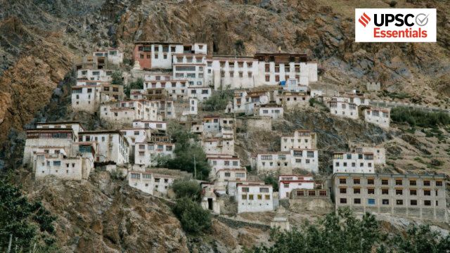 The Himalayas have not yet attained isostatic equilibrium (or gravitational equilibrium) and continue to rise, which makes the region vulnerable to frequent earthquakes of varying intensities. (Julia Volk/Pexels)
— Abhinav Rai
In view of the extensive tectonic vulnerability of the Himalayas, the entire region has been placed under a newly introduced highest-risk Zone VI in the updated seismic zonation map. The map, revealed as part of the revised Earthquake Design Code, 2025 (IS 1893) by the Bureau of Indian Standards (BIS), has placed 61 per cent of India’s landmass (housing 75 per cent of the country’s population) under moderate-to-high seismic hazard risk zones.
Marking a significant shift in India’s seismic hazard assessment in decades, the revised map is expected to change the future of city building and planning, especially in the Himalayan states. The map is updated following global scientific standards using the Probabilistic Seismic Hazard Assessment (PSHA) method, which takes into account both the likelihood and the intensity of ground shaking for any region.
Let’s analyse the key changes made in the revised map, and understand how it seeks to address India’s seismic vulnerability and minimise risk.
Previously, 59 per cent of India’s landmass was considered earthquake-prone and divided into four seismic zones based on the intensity of past events:
Zone II (low)
Zone III (moderate)
Zone IV (high)
Zone V (very high)
Zone V was the most seismically active region, while zone II was the least. The updated map has added one more zone of the highest seismic-hazard category – Zone VI. As a result, 61 per cent of India’s landmass now falls under moderate-to-high seismic hazard risk zones.
The Himalayan belt, which was earlier split across Zones IV and V, has now been put under a single highest risk Zone VI in view of high seismic risk across the entire region (from Jammu and Kashmir to Arunachal Pradesh). In the long-overdue classification, which acknowledges the extensive tectonic vulnerability of the Himalayas, towns and cities that lie on the boundary of any two zones will now automatically be considered in the higher risk zone.
This revision is based on comprehensive data on faults, ground-shaking behaviour, tectonic movements, and underlying lithology (physical character of a rock or rock formation) of the vulnerable regions across the country. During any intense seismic events, the safety of the people depends mainly on two factors:
Structural Elements (SEs): The load-bearing components of a building, like beams, columns, walls, etc.
Architectural Elements and Utilities (AEUs): Non-structural elements held by SEs like glass windows, ceilings, lifts, air conditioning ducts, and other installations for services and utilities.
Traditionally, earthquake-resistant design has largely focused on strengthening SEs. However, damage to AEUs can also jeopardise the safety of the people and structures. Any losses or damage to critical infrastructure, like government buildings, hospitals, schools, commercial complexes, malls, convention centres, and milk and food supply stores, can lead to major socio-economic consequences.
The revised Earthquake Design Code, 2025, seeks to address this gap by laying down standards for the design of SEs and protection of AEUs. These provisions are expected to reduce the damage to both SEs and AEUs during earthquake effects like ground shaking.
Notably, these revisions will help towards achieving two crucial United Nations Sustainable Development Goals (SDGs):
SDG 9 (Industry, innovation and infrastructure): By building resilient infrastructure, promoting inclusive and sustainable industrialisation, and fostering innovation.
SDG 11 (Sustainable cities and communities): By enhancing the safety, resilience, and sustainability of cities and human settlements.
The Indian Plate is still moving towards the Eurasian Plate at nearly 5 cm/year. This ongoing collision led to the formation of the Himalayas – a geologically young region, meaning the rocks are still adjusting, folding and breaking, making the mountains unstable.
Such lithospheric movements also accumulate a lot of stress over time. When that stress is suddenly released, it causes violent shaking of the Earth’s surface and everything over it – this is commonly known as an earthquake. Apart from its direct impacts, earthquakes can trigger secondary disasters such as fires, landslides, liquefaction, tsunamis, etc.
The Himalayas have not yet attained isostatic equilibrium (or gravitational equilibrium) and continue to rise. This makes the region vulnerable to frequent earthquakes of varying intensities. Beneath the Himalayan ranges lie three major fault systems:
Main Central Thrust (MCT): Between the Greater and the Lesser/Middle Himalayas
Main Boundary Thrust (MBT): Between the Lesser Himalayas and Outer Himalayas (Shiwaliks)
Main Frontal Thrust (MFT) or Himalayan Frontal Fault (HFF): Between the Outer Himalayas and Northern Indian Plains
The HFF is the southernmost fault and has densely populated foothills. The recent seismic hazard update has been cautious about the potential southward propagation of rupture along this fault, which could extend the hazards into areas such as Dehradun.
According to the National Disaster Management Authority (NDMA), India has experienced 10 major earthquakes over the last 15 years, resulting in over 20,000 casualties. Historically, India, particularly the Himalayan belt, has been vulnerable to high-magnitude seismic events, sometimes exceeding 8.0.
Four particularly devastating earthquakes happened within a span of 50-55 years, claiming thousands of lives and causing severe damage to properties. They are:
1897 Shillong earthquake (M 8.7)
1905 Kangra earthquake (M 8.0)
1934 Bihar-Nepal earthquake (M 8.3)
1950 Assam-Tibet earthquake (M 8.6)
More recently, the 2001 Bhuj earthquake (M 7.9) claimed 12,932 lives and devastated 890 villages. India’s high seismic vulnerabilities is further evident in the fact that it recorded 159 earthquakes within four months between November 2024 and February 2025.
To minimise seismic risk, the revised map introduced the concept of ‘exposure window’, which considers population density, concentration of infrastructure, urban expansion patterns, and socio-economic vulnerability.
This has been introduced using the Probabilistic Exposure and Multi-Hazard Assessment (PEMA) method. While readjusting the zones, the aim was to consider both physical and geological factors as well as the potential human and economic impacts.
This is particularly important for densely populated cities, where even moderate intensity earthquakes can also cause significant damage. The BIS has urged that all new infrastructure projects and structures be constructed in accordance with the revised guidelines.
The Himalayan states, which are now reclassified into Zone VI, will be required to revise building codes, infrastructure design norms, and long-term urban planning frameworks. Mandatory seismic audits and retrofitting of vulnerable infrastructure will be essential for future preparedness.
Challenges posed by earthquakes as a disaster are unique, as their location, time, and magnitude still cannot be predicted with precision. This necessitates a stronger emphasis on preparedness and mitigation measures to minimise losses. The primary cause of large-scale destruction and casualties during the Bhuj earthquake was the collapse of buildings, including the critical Bhuj Civil Hospital.
This highlights the need to preserve traditional construction practices and integrate the safety provisions, wherever required, to enhance their resilience. There is also an urgent need to retrofit critical older structures of cultural, social, and historical importance to ensure their resilience.
The Prime Minister’s 10-Point Agenda for Disaster Risk Reduction (DRR) also emphasises leveraging technology to enhance the efficiency of disaster risk management efforts. Accordingly, efforts towards improving infrastructure, developing early warning systems, and enforcing safety standards and guidelines are crucial to ensuring safety during future earthquakes.
Analyse how India’s geological setting makes the Himalayan region uniquely vulnerable to high-magnitude earthquakes. How is the introduction of a new highest seismic hazard category (Zone VI) significant for India’s disaster risk governance?
Evaluate the implications of India’s revised seismic zonation map on urban planning and infrastructure development in Himalayan states.
How does the Probabilistic Seismic Hazard Assessment (PSHA) approach seek to improve earthquake risk assessment in India?
How does the concept of an “exposure window” strengthen disaster preparedness in densely populated urban areas?
Why is focusing solely on structural elements insufficient for earthquake resilience, and how does the revised code address non-structural risks?
(Abhinav Rai is a Doctoral candidate at the Department of Geography, Delhi School of Economics, University of Delhi.)
Share your thoughts and ideas on UPSC Special articles with ashiya.parveen@indianexpress.com.
Click Here to read the UPSC Essentials magazine for November 2025. Subscribe to our UPSC newsletter and stay updated with the news cues from the past week.
Stay updated with the latest UPSC articles by joining our Telegram channel – IndianExpress UPSC Hub, and follow us on Instagram and X.

Read UPSC Magazine