© IE Online Media Services Pvt Ltd

 The Air View+, powered by Google AI, offers real-time hyperlocal air quality information in Google Maps for users across India. (Image: Google)
Google has introduced Air View+, an ecosystem-based solution, to help government authorities and people with hyperlocal air quality information. The new feature comes at a critical time when air pollution in Delhi-NCR has soared to alarming levels.
Even though air pollution is leading to significant health challenges, the ability to take action on the hyperlocal level has been limited owing to imperfect data on air quality. Air View+ by Google aims to take this challenge head-on by collaborating with local climate tech firms and local organisations, including local sustainable startups, researchers/climate action groups, corporations, city administrators, and citizens.
In its blog, Google said that climate tech firms such as Aurassure and Respirer Living Sciences were instrumental in setting up an air quality sensor network in cities that previously lacked the requisite infrastructure to monitor air quality. According to Google, these sensors measure air quality parameters such as PM2.5, PM10, CO2, NO2, Ozone, and VOCs, along with temperature and humidity, taking measurements every minute. These sensors are deployed in static locations across over 150 Indian cities such as administrative establishments, utility poles, commercial buildings, etc, and they will continuously monitor air quality.
Google has said that these sensors have been rigorously validated and calibrated with the support of local researchers from IIT Delhi, IIT Hyderabad, state pollution boards, and climate action groups like CSTEP. Google said that the data has been analysed using Google AI by researchers and sustainability startups to compute insights quickly and at scale making it useful for people.
The Air View+, powered by Google AI, offers real-time hyperlocal air quality information in Google Maps for users across India, and makes valuable air quality insights available to government agencies responsible for environmental monitoring and urban planning.
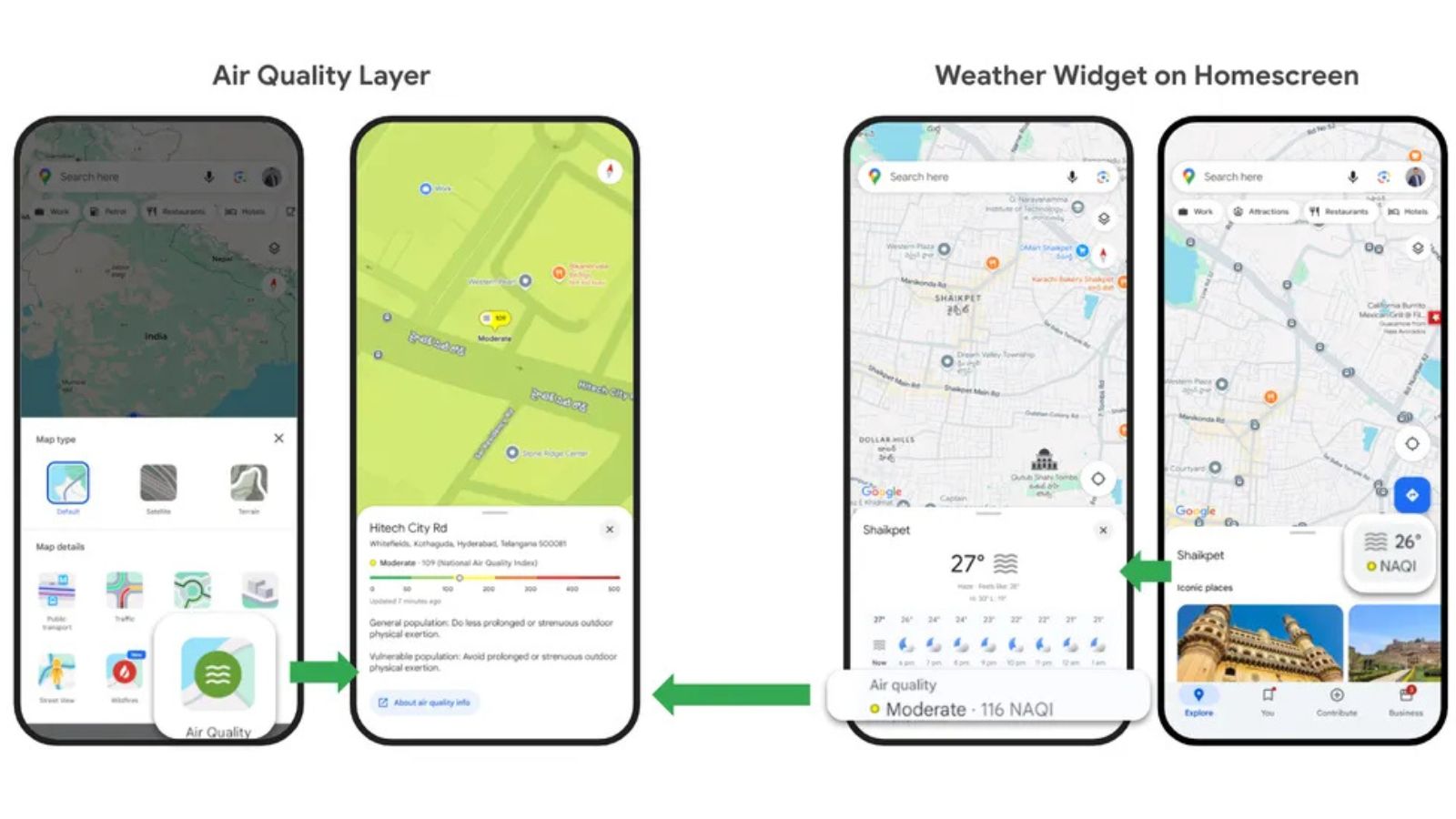
Users can now access hyperlocal air quality information across India using Google Maps. Google achieved this using a multi-layered AI fusion approach that brings together data from various input sources such as sensor networks, government data, satellite imagery, weather and wind patterns, traffic conditions, land cover, and more.
For AQI insights on Google Maps, select the Air Quality layer from the Layer button on the home screen and tap on any location on the map. They can click on the Weather widget on the Explore tab on the home screen on AQI insights from their current location.