Opinion Yamuna floods Delhi: Things are the same, yet they are vastly different
In 1978, Delhi's population was only about 30 lakh. Today, we are at nearly 2 crore, and infrastructure projects and new settlements have come up along the river.
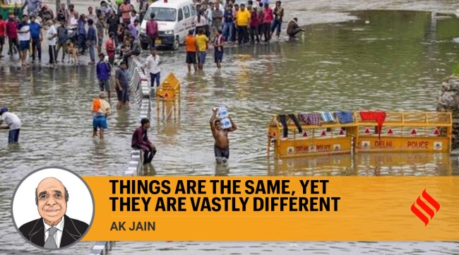 The river needs porous areas to make sure the floodwater is absorbed, but if 40 per cent of the area can be developed legally, we will see more flooding in developed areas in coming years. (Express file photo)


Images of floodwaters entering Delhi and inundating areas along the Ring Road in Delhi took me back to 1978, when a similar rise in water levels brought the floodplains and many roads under water. Things are the same, yet they are vastly different.
In 1978, the city’s population was only about 30 lakh. Today, we are at nearly 2 crore, and infrastructure projects and new settlements have come up along the river.
There was an outpouring of help then. Tents, similar to the ones we saw in Delhi over the past week, came up all along the Ring Road as people were evacuated from low-lying areas. The deluge did not last very long and the water receded within 4-5 days.
The difference then was that there was no dispute between two governments. Delhi was run by a Metropolitan Council and did not have a legislative Assembly. The civic body made arrangements for tents and shelters, and the Council took on other jobs.
I had joined the Delhi Development Authority (DDA) only a year earlier, in 1977, and was responsible for reviewing the city’s Master Plan. After the waters receded, I realised that planning in Delhi had to be about the last man in the line — the poorest of poor.
The problems of Delhi don’t really emanate from the city itself. You have an influx of people from neighbouring states, as well as Bihar, West Bengal and other far-off regions of the country. Even when it comes to things like water, Delhi is not an island. The Yamuna that flows in the city comes from Haryana. This means that the problems in Delhi cannot be solved within the city itself. The solutions lie elsewhere. This is as true today as it was then.
My wife and I were not personally affected by the flooding then. DDA had provided us with government housing in Safdarjung Development Area. At the time, prefabricated housing units were set up there. My father was in the Armed forces and I grew up across the country. After I completed my degree in architecture from Bhopal and my master’s degree in town planning from the School of Planning and Architecture, I made Delhi my home in 1969.
The river and its floodplains were pristine at that time. There wasn’t much construction. The city had very, very few cars and parking was not really an issue. Today, there are parking lots built for all temples along the Yamuna. I remember festivals were celebrated near the river very peacefully. Today, these have been commercialised too.
After the water receded in 1978, we tried to work out ways to improve the population’s relationship with the river. Swathes of land were lying barren and we wanted to turn them into biodiversity parks. This is because the Master Plan initially did not take into account our tradition of having a connection between people and the river. If we look at Shahjahanabad, people were connected to the river. That interaction stopped after the Ring Road came up (in 1953-54) and people were cut off from the Yamuna.
Proposals for floodplain development that came in showed that it was being treated as the backyard of the city. So power stations like Rajghat, sanitary landfill sites and industrial areas like Okhla — all “dirty” things — were placed along the river. Muck and sewage from unauthorised and authorised colonies were dumped here via 22 drains from across the city.
We realised that this was completely incongruous with the city. The perception of the people, including politicians and planners, was that this was vacant land. When the Asian Games took place in Delhi, an indoor stadium and the Players Building (the present Delhi Secretariat) were built on the floodplain because it was viewed as vacant land waiting to be “developed”.
In the early 2000s, international consultants told us that this area should be developed and given to private players to build five-star hotels along the river. They said Delhi’s finances for at least five years could be funded if such construction was allowed without encroaching the sensitive O-Zone. But I was against this. Making money was not DDA’s job. It would defeat the whole purpose of planning. DDA’s job was to ensure we were a socially responsible body and that it showed in our planning. Even today, we have not learnt lessons from the past. Political pressures and vote-bank politics are only increasing.
In the 2041 Master Plan, which is at the draft stage, the river has been divided into two zones. Of the 10,000 hectares of floodplains, around 6,400 hectares has been designated as floodplain. The remaining 3,600 hectares, where a lot of development has taken place, is being designated as “regulated” zones; this means that unauthorised activities and construction can be regulated and regularised. This is all because of political pressure. Many planners and environmentalists are opposing this, but it is being done in an underhanded manner because not many people understand the Master Plan, since it is a technical document.
The river needs porous areas to make sure the floodwater is absorbed, but if 40 per cent of the area can be developed legally, we will see more flooding in developed areas in coming years. Our proposal has always been to develop biodiversity parks along the river to minimise the impact and devastation.
(As told to Mallica Joshi)
AK Jain is the former Commissioner (Planning), DDA