Stay updated with the latest - Click here to follow us on Instagram
Journalism of Courage

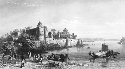 An image of the Allahabad fort.
Over the past 30-35 years, using aerial and satellite remote sensing data, palaeochannels (remnants of an inactive river or stream) have been systematically mapped to discover the course of Saraswati — a river that, as per Vedic texts, once joined the Ganga and Yamuna at the Sangam in Allahabad.
The agencies working on this include the Central Arid Zone Research Institute (CAZRI) in Jodhpur, Geological Survey of India (GSI) in Jaipur, Space Application Centre in Ahmedabad, Regional Remote Sensing Centre in Jodhpur, Rajasthan Groundwater Board, Central Ground Water Board and ONGC. Last year, the Indian Space Research Organisation (ISRO) carried out a project to plot the course of the Saraswati using satellite data.
Saraswati is believed to have had three tributaries: Sutlej arising from Mount Kailash, Drishadvati from Shivalik Hills and the old Yamuna. Together, they flowed along a channel, presently identified as that of the Ghaggar river, also called Hakra river in Rajasthan and Nara in the Sindh region in Pakistan.
Union Water Resources Minister Uma Bharti has said that there is considerable evidence to ascertain the course of the river and the government will try to “trace the route”. Bharti has also instructed officials of the Central Groundwater Board to test water samples from a well inside the Allahabad Fort, a 16th-century building located close to the confluence of the Ganga and Yamuna in the city. As per local lore, the Saraswati flows beneath the deep well, known as ‘Saraswati Koop’.
“Ample scientific evidence from remote sensing to archaeological excavations reveals beyond doubt that Vedic Saraswati river was flowing in northwestern India, sub-parallel to the Indus River around 6000 BC. It became a seasonal trickle around 3000 BC due to climatic and tectonic changes in the Himalayan region,” says Dr J R Sharma, chief general manager, ISRO, and Dr B K Bhadra, senior scientist at ISRO, who have both worked extensively on the project for decades.
In a study initiated in the 1990s, it was concluded that Saraswati originated from Bandarpunch, or Har-ki-dun, a glacier in the Garhwal Himalayas and finally discharged into the Gulf of Khambat on the Gujarat coast.
Today, the Saraswati is represented by the Ghaggar river that flows on its palaeochannel in Haryana, according to ISRO. Around 14 wells were dug near it there, and when the Bhabha Atomic Research Centre carbondated the water, they found it was 8,000-14,000 years old.
More than 100 years ago, British engineer C F Oldham reached the same conclusion and believed the Ghaggar river occupied the bed of a much bigger river, possibly the Saraswati.
Rajesh Purohit, Director of Allahabad Museum, says these are all hypotheses and that to establish the existence of the river, “more exhaustive research on the ground will be required”.
Purohit, an archaeologist, has attempted to trace the existence of Saraswati for nearly 20 years. At Bhoresaida, a few kilometres from Kurukshetra, he found a dried-up river bed in 2006, nearly 80 feet below ground.
Purohit believes in a phenomenon known as “river capturing”, where a larger river takes over a smaller one, changing its course and size. “Yamuna, in Vedic etymology, itself signifies the phenomenon of ‘river capturing’. It is possible that some part of Saraswati was captured by Yamuna and brought east, while the remaining was taken over by Sutlej — the river on the western side of Saraswati’s bed,” he says.
The route mapped out so far, validated through collateral data such as geomorphic anomalies, drilling data of tubewells, age of ground water, archaeological data and old maps, shows the river originated in Kailash Mansarovar and emerged on the plains from the foothills of the Himalayas in Himachal Pradesh. It then flowed through the Ghaggar valley in Haryana and the Thar desert, on to Hakra in the Cholistan desert (Sindh, Pakistan), before reaching the Rann of Kutch through the Nara Valley and emptying into the Arabian Sea.
Many references exist about the Saraswati river meeting the Arabian Sea along the existing Kori Creek. Recent investigations have revealed that more than one river helped build up the deltaic deposits in the Rann.
It has also been observed that many prosperous towns of Harappan culture (3000-1500 BC) existed along banks of what may have been the Saraswati. “The Rig Veda mentions seven rivers which flowed from the Himalayas towards the Arabian Sea. While Indus was the westernmost, Saraswati was the easternmost. In fact, at places it flowed parallel to the Yamuna, providing a region fed by two rivers, which allows for the possibility of a rich civilisation,” says Purohit.
Professor S Ojha, a geography professor at Allahabad University, puts forward a similar theory. “Locally, the confluence point of the Ganga and Yamuna has been shifting. In fact, if you take a map of Allahabad and join the bandhs (embankments), they will virtually form a straight line ending up at Saraswati Ghat on the Yamuna, towards the west of the Allahabad Fort,” he says.
“After all, why would a ghat on Yamuna be called Saraswati Ghat?” asks Purohit.
He adds that he is unsure whether testing water from Saraswati Koop would be enough to establish the presence of the river. “Testing the water can only tell you how old it is. But how will you establish that water is from the Saraswati?” he says. However, he adds, the “idea is still worth pursuing”.
Stay updated with the latest - Click here to follow us on Instagram