© IE Online Media Services Pvt Ltd

 An area submerged due to floods, in Saharsa district of Bihar, on October 1. (Photo: PTI)
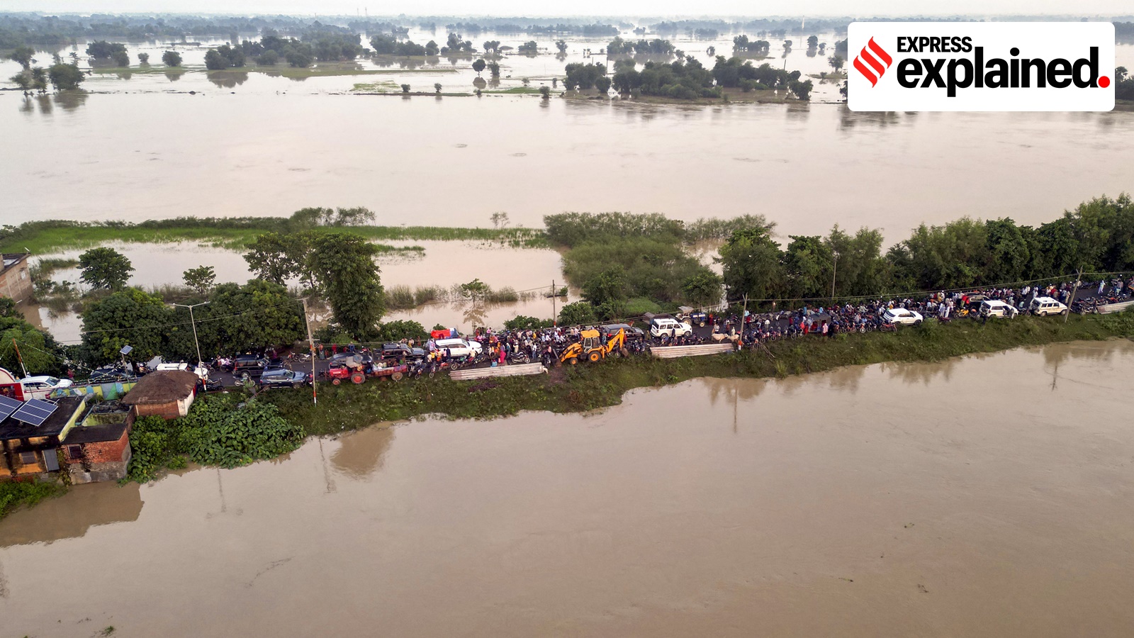
Bihar is flooded yet again, with 11.84 lakh people hit — driven out of their homes, surviving on air-dropped food packets, huddling in shelters, vulnerable to water-borne diseases.
North Bihar sees floods every year. Lakhs of people see their crops and livestock destroyed. They pick up the pieces and start again, only for the story to be repeated the next year.
What makes this region so prone to floods? The answers lie in Bihar’s geography, and a decades-old solution that has proved short-sighted.
According to the state government’s Flood Management Improvement Support Centre (FMISC), “Bihar is India’s most flood-prone state, with 76 per cent of the population in north Bihar living under the recurring threat of flood devastation.”
Bihar is crisscrossed by both snow-fed and rain-fed rivers, putting it at the risk of various kinds of floods.
The state’s Disaster Management Authority has categoried floods into four classes. The first are flash floods, “occurring due to rainfall in Nepal, lead time [time between forecast and flood] is short (8 hours), receding of flood waters is fast.” Then are river floods, where the lead time is 24 hours and receding of flood waters takes one week or more. The authority’s website further says, “Class III: Drainage congestion in river confluence- lead time more than 24 hours, lasting full monsoon season (i.e. receding of flood water takes 3 months); Class IV: Permanent water logged area.”
 Districts in north Bihar are the most prone to flooding. (Photo: Wikimedia Commons)
A major reason for the first three kinds of flooding is that Bihar is located below Nepal, with its Himalayan rivers flowing down to the state. Because the Himalayas are a young mountain range with a lot of loose soil, these rivers — Kosi, Gandak, Burhi Gandak, Bagmati, Kamla Balan, Mahananda, Adhwara — are full of sediments. Thus, when the volume of water increases due to rains, the rivers quickly overflow their banks.
The fourth category of permanent waterlogging is because of several factors. As the Flood Atlas of Bihar, prepared by ISRO along with the central and state governments, says, “The reasons of water-logging are spilling of silted small rivers, encroachment of drainage channels, embankment-induced waterlogging, and presence of saucer type depression locally called Chaurs.” Chaurs are created due to a river changing course and deposition of its sediments.
This year, the flood has been caused by heavy rainfall and flooding in Nepal and release of water from its barrage on the Kosi river. Supaul, Darbhanga, Madhubani, Sitamarhi, West and East Champaran, Muzaffarpur, Siwan, Madhepura, Purnea, Araria, Gopalganj, Kishanganj, Sheohar, Saharsa and Saran.
Given that Bihar’s geography makes floods inescapable, solutions have been sought for decades. Among the more destructive rivers of the state is Kosi, known as the ‘sorrow of Bihar’.
Soon after independence, in the 1950s, embankments were built along the Kosi to contain its flow. While they were seen as a lasting solution, not only have the embankments been breached several times, they have created a new problem.
“Embankments narrowed the course of the river. Thus, while Kosi earlier had the option to distribute its sediments, now it was in a straitjacket. With nowhere for the sediments to go, the river’s bed has been rising by about 5 inches a year, making it more prone to overflowing,” Dinesh Kumar Mishra, convenor of NGO Barh Mukti Abhiyan who has spent decades working for flood relief in the Kosi belt, told The Indian Express.
This time, flooding is worse than the past few years because the Birpur barrage, built on the Kosi in Nepal, released 6.6 lakh cusec of water, the highest in almost six decades. On the Indian side, embankment breaches have been reported from seven places in four districts. Mishra said, “The embankments were built with a capacity of 9.5 lakh cusec of water. They are being breached even with water discharge at a much lower level because the river is now shallower. As many as 380 villages lie within the embankments, home to at least 15 lakh people. They have no escape from the annual floods. The government gave them land for rehabilitation, but of the 1200 hectares, 570 were waterlogged.”
While Bihar floods may not result in loss of lives every year, their economic cost is steep, if one looks at the damage to crops, infrastructure, loss of livestock, and distress migration outside the state. The state government spends about Rs 1,000 crore annually for flood management and relief.
Possible solutions
For decades, the proposal of a dam on the Kosi has been mooted, but since that will require Nepal to come on board too, the plan has not progressed. On September 30, Bihar Deputy Chief Minister and BJP leader Samrat Choudhary met Union Jalshakti Minister C R Patil in New Delhi, and requested the building of “an additional barrage” on the Kosi. The state government is also considering a barrage each at Dagmara (Supaul) over Kosi, in Areraj over the Gandak, and another over Bagmati.
However, the experience with embankments shows that engineering solutions might not be enough to fix the Kosi problem.
Anil Kumar Sinha, founder vice-chairman of the Bihar State Disaster Management Authority from August 2010 to September 2016, told The Indian Express, “There are two ways of dealing with floods — one is through structural solutions, which includes dams, embankments, etc., and the other is through non-structural solutions, which includes laws, policy, risk reduction, mitigation, etc. In Bihar, because its geography can’t be changed, there is a great need to work on aspects like adequate warnings, quick reaction times, awareness and training in dealing with floods, etc.”
The Flood Atlas of Bihar also says, “There must be a realisation that minimising the risk and damage from floods may be a more rational way of flood management rather than formulating structural measures along dynamic rivers such as the Kosi.”