© IE Online Media Services Pvt Ltd
Journalism of Courage

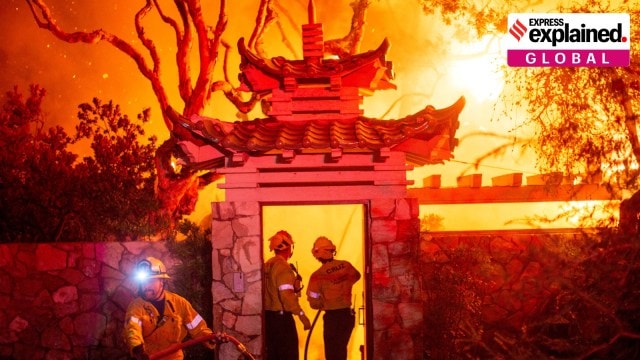 Southern California wildfires 2025 explained: Firefighters battle the Palisades Fire on January 8. (Photo: Reuters)
Palisades fire, Santa Ana Winds and Climate Change: Wildfires continued to blaze across Los Angeles, California, on Friday (January 9), killing 10 people, forcing over 130,000 people to evacuate, and burning down homes, including of celebrities like Paris Hilton, Adam Brody, Billy Crystal, and others.
Some of the blazes still burning are the Palisades fire, the Eaton fire, Sunset, Hurst, and Lidia fires. Hollywood Hills is among the areas affected, and the Oscars nominations announcement has been delayed by two days because of the fire.
While California is no stranger to wildfires, the current flare-up is very big and very fast. More remarkably, it is in winter, traditionally not the wildfire season. So why is Los Angeles burning at this time, and why is the fire so bad?
It is not yet known what sparked the wildfires, although power cables blowing in the wind are a likely cause. But three factors made the conflagration blow up. We explain.
Wet weather, followed by dry weather
The last two winters, in 2022 and 2023, were unusually wet for the Los Angeles region. This led to lots of trees and shrubs sprouting up. Now, this winter has been exceptionally dry for Southern California. Thus, all the vegetation has dried up, literally sitting like dry kindling in the path of flames.
According to NASA, “Since October, Southern California has received negligible rain, and according to climate scientist Daniel Swain, the region has experienced the driest start to the winter on record. The Los Angeles airport, for example, recorded 0.03 inches (0.08 centimeters) of rain since October 1—the start of the water year in the state—making it the area’s driest start to the water year on a record maintained by the National Weather Service dating back to 1944.”
Santa Ana winds are common in California in this season, but this year, they are unusually strong. Thus, once a fire started in the prevailing dry conditions, the strong winds made the flames get bigger and spread faster.
Between October and January high pressure builds up in the deserts of the Great Basin. This high pressure system circulates clockwise and brings wind westwards, towards the coast — different from the usual system of wind blowing inland from the sea. This wind blows down over the Sierra Nevada and Santa Ana mountains, losing humidity, heating up, and, as it is squeezed through mountain passes, gaining a lot of speed. Thus, by the time it is blowing over southern California, the wind is fast, dry, and warmer.
It is this wind that is blowing flames across Los Angeles, which are devouring the kindling of dry vegetation, power cables, wooden houses built to withstand earthquakes, etc.
Climate change
Across the world, climate change is making extreme weather events more devastating. As The Indian Express has earlier explained, “Experts say the wildfire season in California has lengthened in recent years. For instance, a 2021 study, published in the journal Nature Scientific Reports, found that the state’s annual burn season has lengthened in the past two decades and that the yearly peak has shifted from August to July. The wildfires have also become more intense in the past few years… Rise in global temperatures over the years has led to warmer springs and summers, and early spring snow melts. Such conditions cumulatively cause longer and more intense dry seasons, putting more moisture stress on vegetation.”