


© The Indian Express Pvt Ltd
Tags:

On almost all days in June so far, North and Northwest India have experienced ‘heatwave’ to ‘severe heatwave’ conditions. The southwest monsoon that made an early onset over Kerala has advanced until Maharashtra, but maximum temperatures in the plains of North India have sustained around 45-47 degrees Celsius.
The June-September southwest monsoon brings more than 70% of India’s annual rainfall. Climatologically, the monsoon arrives over the Andaman Sea in the third week of May and advances into the mainland through Kerala, June 1 being the normal date of onset.
It then advances in surges — typically, the progress until central India is fast, after which it slows down. The monsoon normally reaches north Uttar Pradesh, Delhi and neighbourhood areas by the end of June, and covers the entire country by July 15.
An early or timely onset of the monsoon does not guarantee good rainfall or its distribution over the country throughout the four-month season. And a delayed onset does not necessarily mean below-average rainfall for the entire season.
Cumulative rainfall over the country from June to September depends on multiple factors. It also shows natural inter-annual variability, which makes every monsoon different. Alongside the quantum of rainfall, its distribution is also vital.
The India Meteorological Department (IMD) has forecast ‘above normal’ rainfall this season. Quantitatively, it is expected to be 106% of the Long Period Average of 880 mm (1971-2020 data).
The ‘above normal’ rainfall is being attributed mainly to the soon-to-emerge La Niña conditions, which are known to positively influence the Indian monsoon, and a positive phase of the Indian Ocean Dipole (IOD).
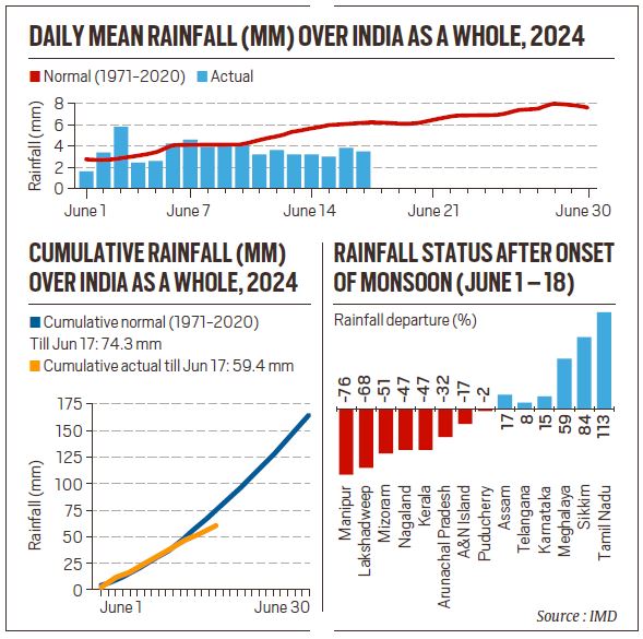
The monsoon arrived over the Andaman Sea and Nicobar Islands on May 19, and hit the Kerala coast on May 30, two days ahead of its normal date. It reached over Nagaland, Manipur, Mizoram, Arunachal Pradesh, and parts of Tripura six days early — marking a rare but not-unheard-of simultaneous onset over Kerala and large parts of Eastern India.
After May 30, the monsoon progressed every day, and it had covered Andaman & Nicobar Islands, Kerala, Lakshadweep, Mahé, Tamil Nadu, Puducherry, Karnataka, Telangana, and large parts of Andhra Pradesh and Maharashtra by June 10.
This kept the all-India rainfall positive at 36.5 mm, or 3% surplus as on June 10. Over all these states and UTs, the monsoon arrived three to five days early.
From June 11 onward, the monsoon has remained stagnant, and dry and hot conditions have returned to the Southern peninsula. Over the past week, all-India rainfall has been consistently below average. On Tuesday, it was minus 20% (64.5 mm against normal 80.6 mm).
“Initially, the monsoon came in as a big current but did not bring much rain. This is not a typical monsoon flow, compared to what was expected,” M Rajeevan, former secretary, Ministry of Earth Sciences, said.
On Tuesday, the Northern Limit of Monsoon — the imaginary line indicating the monsoon’s progress — passed through Navsari, Jalgaon, Amravati, Chandrapur, Bijapur, Sukma, Malkangiri, Vizianagaram and Islampur.
The overall deficit is mainly due to states where the onset of the monsoon has been delayed. These include Odisha (minus 47%), West Bengal (minus 11%), Bihar (minus 72%) and Jharkhand (minus 68%) as on Tuesday.
The return of dry conditions over Manipur, Mizoram, Lakshadweep, Nagaland, Kerala, Arunachal Pradesh, Andaman and Nicobar islands, too, has contributed to the deficient all-India rainfall.
The IMD declared onset over Kerala on May 30, and the monsoon advanced over large parts of eastern India on the same day, mainly due to Cyclone Remal, which made landfall over the West Bengal and Bangladesh coasts on May 26, and its remnants travelled further inland. Heavy to very heavy rain lashed Assam, Meghalaya, Tripura, and Sikkim, leading to floods, mudslides, and landslides in early June.
Strong westerly/ southwesterly winds from the Arabian Sea propelled the monsoon over the Southern peninsula in early June. Multiple cyclonic circulations along the western coast also provided conducive conditions until June 10, after which the absence of synoptic systems led to the southwesterly winds losing steam and the monsoon weakening.
“In the absence of strong easterly winds, the Bay of Bengal branch of the monsoon [too] could not advance. We will have to wait for a fresh pulse and monsoon trough to establish itself, so that the monsoon system regains strength,” D Sivananda Pai, senior meteorologist at IMD, said.
The monsoon is currently active over Arunachal Pradesh, Assam, Meghalaya, Sikkim, Nagaland, Manipur, Mizoram, Tripura and sub-Himalayan West Bengal. Rainfall activity will pick up along Konkan and northern Karnataka during the latter half of this week. But all other regions of the country will remain dry.
Towards the end of this week, the monsoon could advance into the remaining areas of Maharashtra, some areas of West Bengal, Odisha, some areas of Chhattisgarh and Bihar, and coastal Andhra Pradesh.
“We expect the monsoon to revive towards the end of June,” Pai said. However, it remains uncertain when the monsoon could set in over northern India.
The IMD has said that some respite in the heatwave is likely over Jammu and Kashmir and Himachal Pradesh during this week. Warm nights and hot conditions shall persist over Uttar Pradesh, Haryana, Delhi, and Chandigarh until Wednesday, but will abate thereafter. The June rainfall may end up below normal over the country.

