


© The Indian Express Pvt Ltd
Tags:
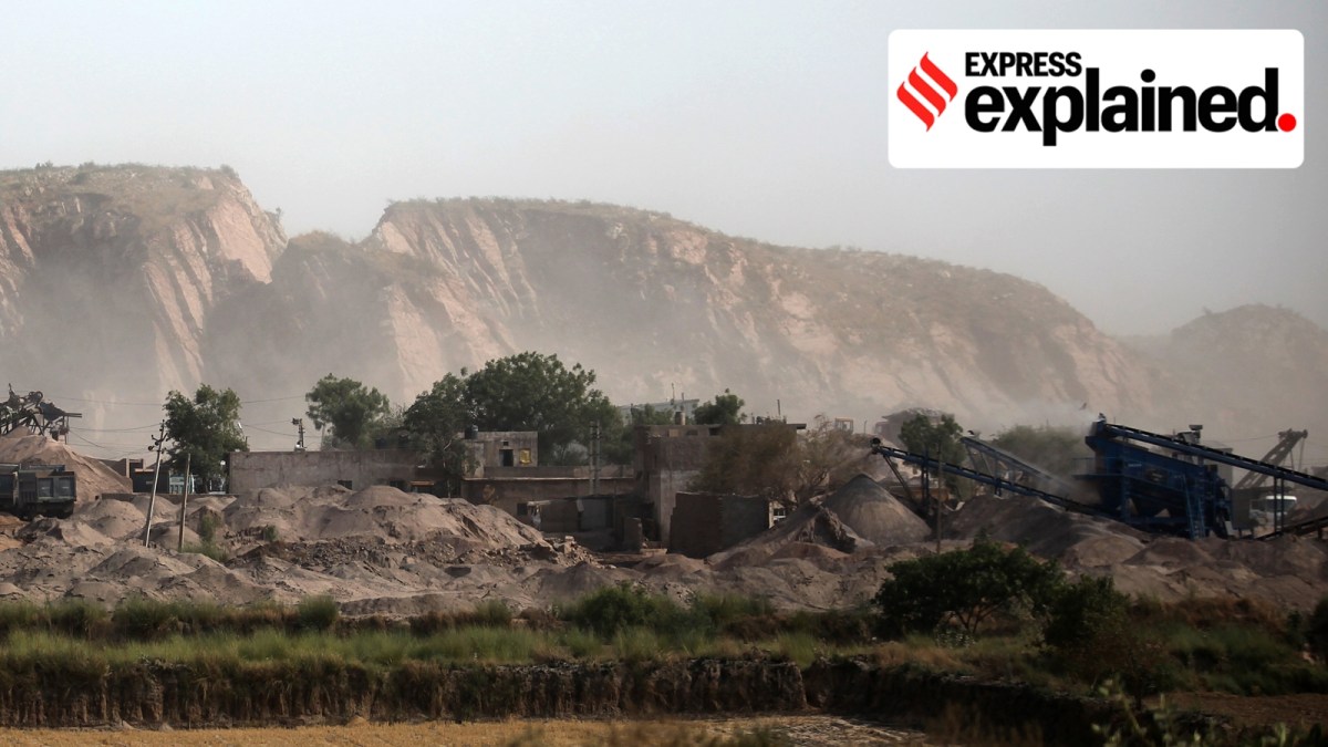
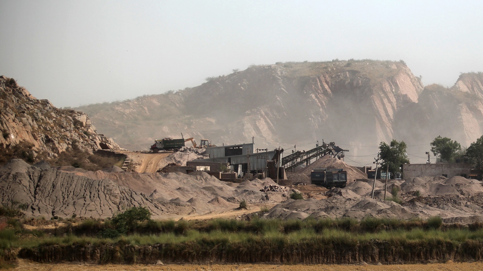
Aravalli Hills Controversy: Amid protests and criticism over the government’s new definition of the Aravalli Hills, the Union Environment Ministry said in a statement Sunday that there was “no imminent threat to the Aravallis’ ecology” and that the hills “remain under robust protection”.
Separately, Union Environment Minister Bhupender Yadav said on Sunday as well as Monday that mining would be permissible in only 0.19% of Aravalli’s “total expanse of 1.44 lakh sq km”.

But the 100-metre benchmark and the use of local relief — the immediate surroundings of a hill — as the measuring base rather than a standardised baseline such as the state’s lowest elevation would result in a very significant part of the Aravalli range not being counted as Aravalli any more.
Sunday’s Environment Ministry statement also said that no new mining leases would be allowed until a detailed study is undertaken according to the November 20 order.
But government statements do not address the ministry’s contested submissions to the apex court or the threats facing the Aravallis other than mining, all of which have severe environmental ramifications.
What remains protected
Parts of Aravallis are designated as tiger reserves, national parks, sanctuaries, eco-sensitive zones around these protected areas, wetlands and plantations under the compensatory afforestation scheme. These areas remain out of bounds for mining or development, unless permitted specifically under the relevant wildlife and forest Acts, irrespective of their status as Aravalli Hills.
Even such protection is not necessarily permanent. As reported by The Indian Express on June 22, 2025, the ministry and Rajasthan attempted to “rationalise” the boundaries of the Sariska tiger reserve, which would have allowed mining now barred in the vicinity of the reserve limits, until the Supreme Court intervened.
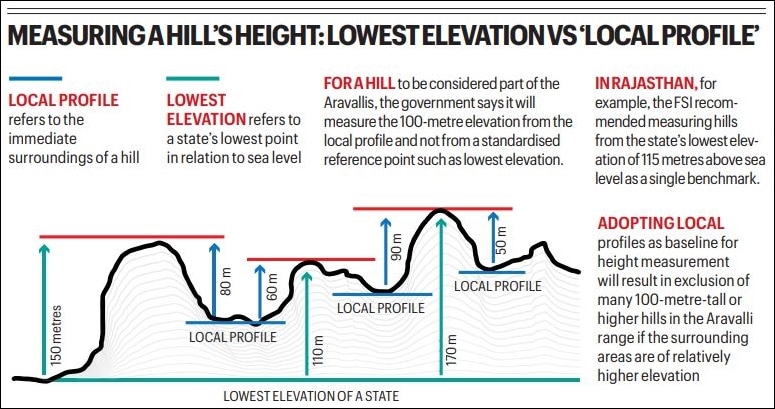
It is important to note that the new Aravalli benchmark does not exclude all landforms under a 100-metre elevation from the range. It identifies all landforms rising at least 100 metres from the local profile as Aravalli Hills. And it is only when two such hills are less than 500 metres apart that the intervening stretch — irrespective of its elevation — will also be counted as part of the range.

What is excluded
The new parameters will leave out large tracts identified as part of the Aravalli range under the Forest Survey of India’s (FSI) 3-degree slope formula which counts all areas above the minimum elevation of an Aravalli state — 115m in case of Rajasthan — with a slope of at least 3 degrees as Aravalli. Rajasthan accounts for nearly two-thirds of the mountain range.
Besides, a number of districts have been dropped altogether from the list of 34 Aravalli districts — across Gujarat, Rajasthan, Haryana and Delhi — submitted by the Environment ministry to the Supreme Court.

For example, Rajasthan’s Sawai Madhopur district, famous for the Ranthambhore tiger reserve located at the convergence of the Aravalli and the Vindhya hill ranges, is not in the list. Also missing is the district of Chhitorgarh, famous for the fort built on a high Aravalli outcrop and a UNESCO World Heritage Site. Rajasthan’s Nagaur district, where the Forest Survey of India identified 1,110 sq km as Aravalli, is also excluded.
The minister said that mining areas make up only 0.19% of the Aravalli’s “1.44 lakh sq km” span. But the extent of the Aravallis he cited is overstated as 1.44 lakh sq km covers almost the entire landmass of all 34 Aravalli districts on the ministry’s list.
Under the FSI’s 3-degree slope formula, the Aravallis cover 40,483 sq km in 15 districts of Rajasthan — roughly 33% of these districts’ total area of 1,23,086 sq km. The 100-metre definition would exclude 99.12% (1,17,527) of the 1,18,575 Aravalli hills, with their slopes and surroundings, identified by the FSI in these 15 districts.
What the Centre told top court
As reported by The Indian Express on November 26, the FSI flagged these concerns to the ministry. But the ministry told the Supreme Court that the 100-metre definition would lead to the inclusion of a larger area under the Aravalli range compared to the FSI’s 3-degree formula.
The ministry told the top court that the average slope in 12 of 34 Aravalli districts (across four states) on its list was under 3 degrees, implying that these districts would be excluded from Aravalli if the FSI’s 3-degree slope formula was accepted. It glossed over the fact that most parts of these districts are plains and, taken as a whole, the average slope of such a district would naturally be far lower than the slope of its hilly areas.
The ministry also said the 100-metre elevation would be measured from the local profile and not from a standardised single reference point, such as the FSI’s use in Rajasthan of the state’s lowest elevation: 115 metres above sea level.
Adopting local profiles as baselines for height measurement will result in exclusion of many 100 metre or higher hills from the Aravalli definition if the surrounding areas (saddles) are of relatively high elevation (see graphic).
Inclusion vs exclusion
On Sunday, the minister underlined the relatively smaller scope for legal mining in Aravallis, but questions remain over the extent of illegal mining, the future scope of mining in the areas excluded under the 100-metre definition, and the impact of every mining block on the surrounding landscape.
And there are activities besides mining that can lead to environmental harm. The 100-metre definition will derecognise most hilly tracts as Aravalli in Delhi NCR where the end ranges significantly lose their height. This could unlock large areas to be developed as prime real estate.
In its report submitted to the apex court, the ministry-led committee noted that “not every part of the Aravalli is a Hill, and not every Hill is part of the Aravalli” and emphasised “the risk of inclusion errors if slope alone is used for boundary demarcation.”
While acknowledging the non-hilly areas of Aravalli, the submission puts the focus on avoiding “inclusion” — rather than exclusion — of areas under Aravalli.


