Journalism of Courage
IRNSS
IRNSS NEWS

Knowledge Nugget: What is RFID technology in FASTag? Key concept for your UPSC exam
June 24, 2025 11:11 am
FASTag-based annual passes address the “long-standing concerns” related to toll plazas. But what is the technology behind FASTag? What is the plan for a satellite-based tolling system? In ‘Beyond the Nugget’, learn about the NavIC system.

Latest position
May 02, 2016 12:01 am
IRNSS morphs into Navic, bringing India its very own, completely secure GPS systems.
India gets its own GPS
November 24, 2017 2:21 pm
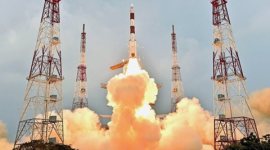
IRNSS-1G is the seventh of the Indian Regional Navigation Satellite System (IRNSS). Like its six predecessors, it had a lift-off mass of 1,425 kg.
ISRO's sixth navigation satellite IRNSS-1F: All you need to know
March 10, 2016 2:49 pm
The satellite will be launched into orbit from the Satish Dhawan Space Centre (SDSC) at Sriharikota in Andhra Pradesh.
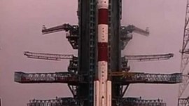
ISRO works on 4 back-up satellites for IRNSS
January 08, 2016 4:32 am
IRNSS will provide services like terrestrial, aerial and marine navigation, help in vehicle tracking and fleet management, disaster management and navigational aid for hikers and travellers among others.

Explained: Guardian in the sky
March 29, 2015 12:42 am
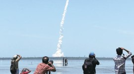
IRNSS 1D, which was launched on Saturday from Sriharikota, is the fourth satellite to be launched.
Well find our own way
July 07, 2013 4:25 am
With the first of the seven navigation satellites in space,India has joined the race for an independent navigation system
IRNSS VIDEOS
ISRO launches India's fifth navigation satellite IRNSS-1E
January 20, 2016 5:57 am
Sriharikota, Jan 20 (ANI): The Indian Space Research Organisation (ISRO) on Wednesday successfully launched India's fifth navigation satellite, IRNSS-1E. ISRO's proven workhorse PSLV-C31 is set to put the satellite in the sub-geosynchronous orbit in its 33rd flight from the nation's spaceport at Sriharikota. The Indian Regional Navigation Satellite system, IRNSS, consists of seven satellites and will provide real-time data on the position of objects to aid road, air and maritime traffic apart from providing mapping and tracking services.
Advertisement
Best of Express


EntertainmentI am a Muslim, composing for Ramayana, says AR Rahman: 'I studied in a Brahmin school, value the good things'

EntertainmentBorder 2 trailer: Army, Navy and Air Force unite as Sunny Deol returns to the frontline


ExplainedIndia has surpassed China in rice production. But this love for paddy is not without pitfalls


Advertisement


Advertisement