


Stay updated with the latest - Click here to follow us on Instagram
© The Indian Express Pvt Ltd
Tags:
On November 20, the Supreme Court accepted the recommendations of a Union Environment Ministry panel on the definition of Aravalli Hills ostensibly to restrict mining: any landform that is at an elevation of 100 m or more above the local relief will be considered as part of Aravalli Hills along with its slopes and adjacent land.
What the panel did not mention is that by this definition, more than 90% of the Aravali Hills will not be counted as Aravalli anymore and be potentially open to mining and construction with severe environmental ramifications, including the quality of air in the National Capital Region.

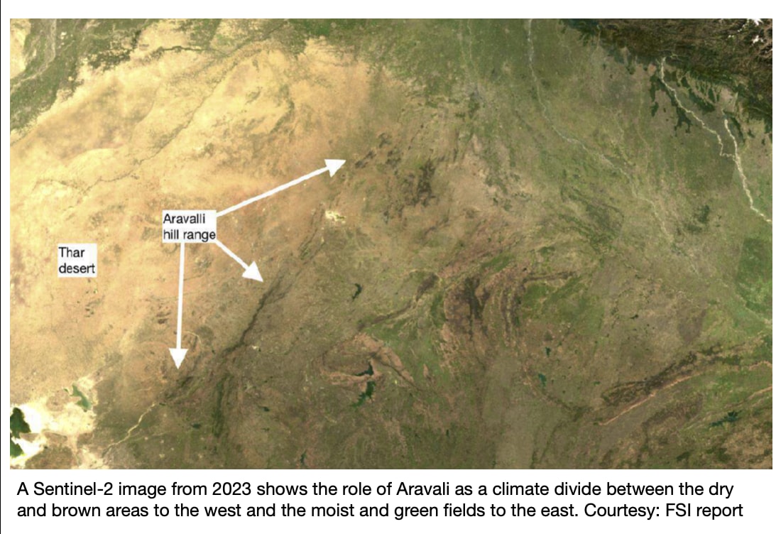
Aravalli extends from Delhi in the north to Gujarat in the south through Haryana and Rajasthan.
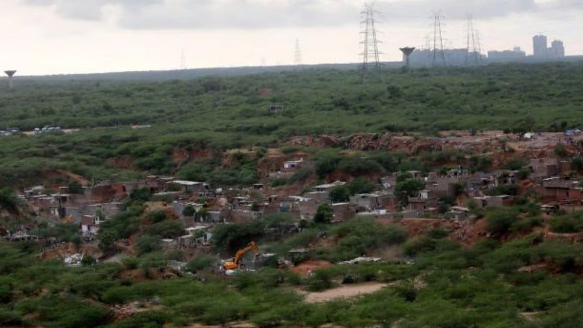
Rajasthan accounts for nearly two-thirds of the mountain range. For decades, the hills have been under severe pressure from mining, both legal and illegal, and other development activities such as construction.
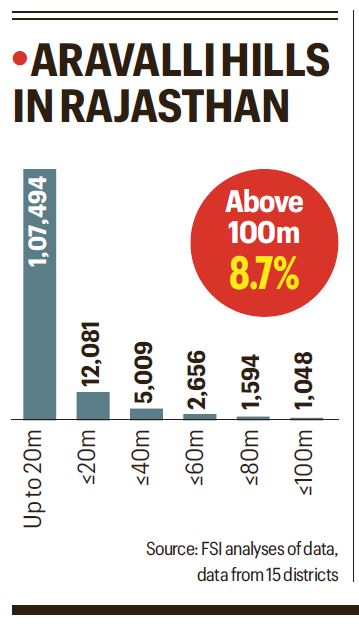
Last year, the SC had asked the government to come up with an uniform definition of the Aravalli. While the FSI has been using a 3-degree slope yardstick to define Aravalli Hills since 2010, a technical committee formed for the purpose in 2024 modified the benchmark and proposed to identify as Aravalli Hills any landform with a slope of at least 4.57 degrees and a height of at least 30m. These yardsticks would effectively cover upto 40% of the Aravallis.
Yet, the ministry prescribed the 100-m definition to the SC in an unsigned report as part of its affidavit. It also conflated slope and height parameters to justify the new definition, proposed subjective height references that, experts red-flag, may lead to the exclusion even of many hills 100-m or higher.
“The FSI cautioned that the 100-m cut-off would protect only a few guard posts while surrendering the fences below. Loss of lower hills is likely to expose vast areas to sand and dust particles blowing from the Thar desert to the Indo-Gangetic plains and endanger the livelihood of farmers and health of people, including those living in Delhi-NCR,” said an Environment ministry official on condition of anonymity.
Consider the telling submissions by the ministry in the affidavit:
Slope dilution: The ministry told the SC that the average slope in 12 of 34 Aravalli districts (across four states) on its list was under 3 degrees implying that these districts would not be categorised as Aravalli Hills if the FSI’s 3-degree slope formula was accepted. It glossed over the fact that most parts of these districts are plains and, taken as a whole, the average slope of such a district would naturally be far lower than the slope of its hilly areas.
Height distortion: The ministry justified its 100-m cutoff by arguing that the “average ground elevation” of not a single Aravali district was below 100 m. But the average elevation of the district is measured in terms of height above mean sea level, while the hills are measured over and above their immediate surroundings, making the two sets of numbers incomparable. In other words, if a hill is 190 m above sea level, under the new definition, it will not be counted as Aravalli since the surrounding areas themselves are more than 100 m above sea level — making the hill effectively 90 m high.
Area excluded: The ministry’s list of 34 Aravalli districts across four states left out many districts with an established presence of Aravalli. For example, Rajasthan’s Chhitorgarh district, famous for the fort built on a high outcrop of Aravalli and a UNESCO World Heritage Site, is not in the list. Also missing is the district of Sawai Madhopur famous for Ranthambhore tiger reserve nestled at the convergence of the Aravalli and the Vindhya hill ranges.
The ministry’s affidavit noted considerable variation and heterogeneity in both elevation and slope within the Aravalli as well as the occurrence of similar topographic features in adjoining non-Aravalli regions, cautioning that using only these two parameters may lead to inclusion errors.
“There can be variation in elevation and slope in many areas so the Government should have erred on the side of caution, instead it has leaned in favour of exclusion from protection,” said environmental lawyer Ritwick Dutta.
As air pollution tightens its chokehold on Delhi, the contribution of the Aravallis assumes importance. While the upper Aravalli is an important barrier to finer pollutants like PM2.5, the lower hills block heavier sand particles. Together, they also function as key wildlife corridors between protected areas, such as Sariska and Ranthambhore.
Asked about these, Environment Secretary Tanmay Kumar said in a written reply: “In its final judgment on November 20, the Supreme Court, while commending the work of the committee, has also appreciated its recommendations aimed at preventing illegal mining and permitting only sustainable mining in the Aravalli Hills and Ranges. The Hon’ble Court has accepted the committee’s recommendations relating to: (i) the uniform definition of the Aravalli Hills and Ranges; (ii) prohibition of mining in core/ inviolate areas; and (iii) measures for enabling sustainable mining and preventing illegal mining in the Aravalli Hills and Ranges.”
Santosh Tiwari, Director General, FSI, said he took charge only recently and would look into the matter.
A CEC member said that the committee did not receive any “formal report” from the FSI on Aravalli.
Former FSI Director General Anoop Singh, under whom the definitions were formalised, has been repatriated to his parent cadre Andhra Pradesh on October 31. When asked about the panel ignoring FSI’s concerns, he said: “I am no longer with the FSI and cannot comment on these matters.”
In May 2024, the SC had asked the ministry to form a committee under the Environment Secretary to “come out with a uniform definition” for Aravalli to protect the hills from mining. This committee, in turn, formed a technical sub-committee (TSC) in June 2024 under the FSI with Geological Survey of India (GSI) and Survey of India (SOI) as members.
Back in 2010, the FSI had proposed that all areas above the minimum elevation of an Aravalli district — 115m in case of Rajasthan — with a slope of at least 3 degrees be delineated as hills together with a uniform 100-metre-wide buffer downhill. A succession of such hills within 500m intervals were to be considered a hill range.
In October 2024, the FSI-led sub-committee modified this benchmark to define Aravalli Hills and Ranges as “the Proterozoic fold belt… forming a linear series of alternate hills (including tablelands) and valley” with a slope of at least 8% (4.57 degree) and elevation of at least 30m.
In September 2025, the FSI submitted a report to the Environment Secretary, presenting districtwise hill maps of the entire Aravalli region. “Even modest hills of 10-30 m act as strong natural windbreaks, creating sheltered zones that extend many times their height downwind and thereby effectively halting near-surface sand transport,” the report said.
In October, however, the ministry submitted to the SC that the Aravalli states “have agreed to the criteria of elevation of 100 m and above from the local relief/ ground level, along with supporting slopes, presently followed by Rajasthan for regulating mining in the Aravalli Hills and Ranges.”
Accepting the 100-m height definition last week, the apex court has asked the ministry to develop a Management Plan for Sustainable Mining with the help of Indian Council of Forestry Research and Education (ICFRE) for the Aravalli Hills under the new definition.
Stay updated with the latest - Click here to follow us on Instagram

