


© The Indian Express Pvt Ltd
Tags:
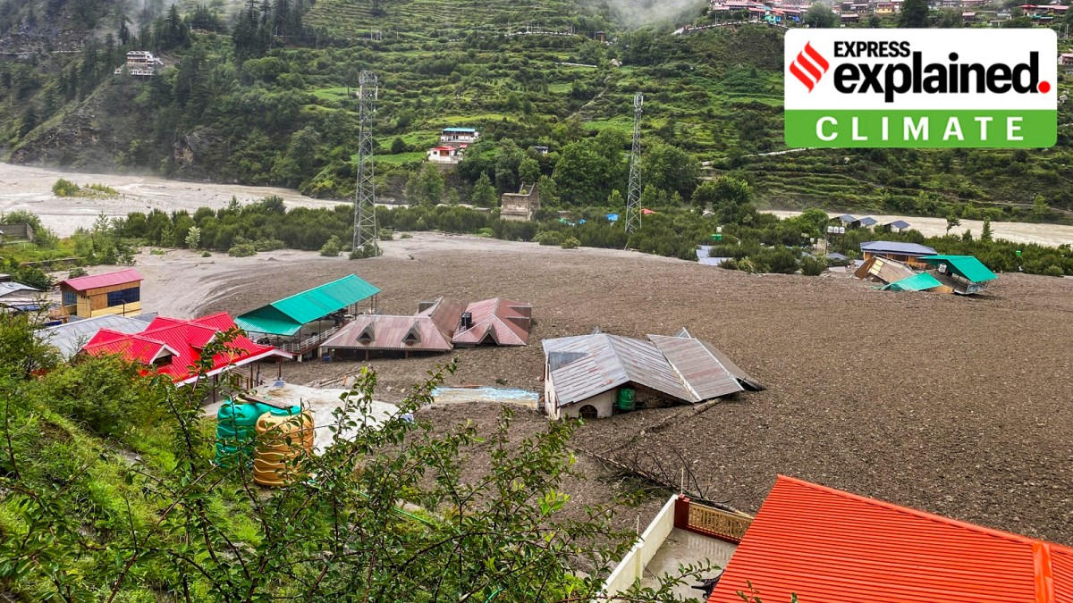
The breaking of a glacial lake accompanied by heavy rain is suspected by some experts to have caused the flash flood in Dharali village in Uttarkashi in Uttarakhand on Tuesday (August 5).
Glaciologist Anil V Kulkarni, a distinguished scientist at Divecha Centre for Climate Change at the Indian Institute of Science, Bengaluru, has told The Indian Express that satellite images from September 2022, a non-winter month, showed evidence for past lake formations in the area from where the Kheer Ganga river, which caused the flood, originates.
If another lake had indeed formed recently, it could have been breached due to movements in glacier mass, Dr Kulkarni said.
Officials at the National Disaster Management Authority (NDMA) said they were looking at the possible detachment of a glacial snout (the ‘nose’ of a glacier where it breaks) that could have carried massive quantities of debris downstream.
More than 60 people are still reported to be missing as rescue operations entered the fourth day on Friday.
In October 2020, the NDMA, which is headed by Prime Minister Narendra Modi, had issued detailed guidelines on ways to deal with disasters caused by what is technically referred to as a Glacial Lake Outburst Flood (GLOF).
According to the NDMA, the retreat of glaciers as a result of climate change that is occurring in most parts of the Hindu Kush Himalayas has given rise to numerous new glacial lakes, breaches in which can cause Glacial Lake Outburst Floods (GLOFs).
A GLOF occurs when a large mass of water dammed by a glacier or a moraine is released suddenly. When glaciers melt, the water in these glacial lakes accumulates behind loose naturally-formed “glacial/ moraine dams” made of ice, sand, pebbles, and ice residue. Unlike earthen dams, the weak structure of the moraine dam leads to its abrupt failure, which can release millions of cubic metres of water in a short time, causing catastrophic flooding downstream. Peak flows as high as 15,000 cubic metres per second have been recorded during such events.
Since glaciers in the Himalayas are in a retreating phase, glacial lakes are growing, and pose a potentially large risk to downstream infrastructure and life.
The National Remote Sensing Centre (NRSC) had completed a project during 2011-15 on “Inventory and Monitoring of Glacial Lakes/ Water Bodies in the Himalayan Region of Indian River Basins”, sponsored by the Climate Change Directorate of the Central Water Commission (CWC). It was observed at the time that there were 352, 283, and 1,393 glacial lakes and water bodies in the river basins of the Indus, Ganga, and Brahmaputra respectively.
The NDMA guidelines say that risk reduction has to begin with identifying and mapping such lakes, taking structural measures to prevent their sudden breaches, and establishing mechanisms to save lives and property in times of a breach.
According to the NDMA, potentially dangerous lakes can be identified on the basis of the condition of lakes, dams, associated mother glaciers, and topographic features around the lakes and glaciers.
The identification of these lakes are based on field observations, processes and records of past events, geomorphological and geotechnical characteristics of the lake/ dam and its surroundings, and other physical conditions.
NDMA has recommended the use of Synthetic Aperture Radar (SAR) imagery to detect changes in water bodies, including the formation of new lakes, during the monsoon months. It has said that methods and protocols could be developed to allow all-year remote monitoring of lake bodies from space as a complement and a precursor to ground-based early warning systems at critical lakes.
Structurally, the management of the situation requires a reduction in the volume of the water in the lake. This can be done through controlled breaching, the construction of an outlet-control structure, pumping or siphoning out the water from the lake, and making a tunnel through the moraine barrier or under an ice dam.
One such landslide that occurred along the Phuktal river, a tributary of the Zanskar river, on December 31, 2014 about 90 km from Padum in Kargil district of Ladakh, led to the blockage of the river and eventually a potential flood situation on May 7, 2015.
The NDMA created an Expert Task Force drawn from various organisations, which, along with the Indian Army, used controlled blasting and manual excavation to clear the landslide debris and channel the water from the dammed river.
How well is India prepared to handle situations such as these?
According to NDMA, while the Central Water Commission (CWC) has done some work on the identification of such lakes, work on building a robust early warning system (EWS) and a broad framework for infrastructure development, construction, and excavation in vulnerable zones is still continuing.
“In contrast to other countries, there are no uniform codes for excavation, construction, and grading codes in India. Restricting constructions and development in GLOF/ LLOF prone areas is a very efficient means to reduce risks at no cost,” the NDMA guidelines said.
According to the NDMA, no construction of habitation should be allowed in the high-hazard zone. “Existing buildings are to be relocated to a safer nearby region and all the resources for the relocation have to be managed by Central/ State governments. New infrastructure in the medium hazard zone have to be accompanied by specific protection measures,” it said.
NDMA has also emphasized that land use planning which avoids the hazards and minimizes the risks is the most effective and economical way to reduce losses caused due to landslides.
“There are no widely accepted procedures or regulation in India for land use planning in the GLOF/ LLOF prone areas. Such regulations need to be developed concerning the increased risk of future GLOF/LLOF events. …There should be monitoring systems prior to, during, and after construction of infrastructure and settlements in the downstream area,” it has said.
One of the most promising options for efficient and effective disaster risk management is the implementation of EWS.
The number of implemented and operational GLOF EWS is still very small, even at the global scale. In the Himalayan region, only three cases – two in Nepal and one in China – have been reported where sensor- and monitoring-based technical systems for GLOF early warning have been implemented.
However, India does have a remarkable history of successful warnings in relation to Landslide Lake Outburst Floods (LLOFs) dating back to the 19th century.
In 1894, after a landslide in Gohna in today’s Uttarakhand dammed the main river, the engineer in charge estimated on July 5 of that year that the lake would overflow the dam in mid-August – which eventually happened.
Despite the devastating impact of the flood, including washing away of most of the buildings along the river and severe destruction in the town of Srinagar (Uttarakhand), no deaths were reported, thanks to the precise prediction of the event and related efficient dissemination of the early warning to the population. This was made possible by the installation of a telephone line between the lake and downstream towns such as Chamoli, Srinagar, etc.
* Apart from calling in specialised forces such as the National Disaster Response Force (NDRF), Indo-Tibetan Border Police (ITBP) and the Indian Army, the NDMA has emphasised on the need to have trained local manpower.
“Experience has shown that over 80 per cent of search and rescue is carried out by the local community before the intervention of the state machinery and specialised search and rescue teams. Thus, trained and equipped teams consisting of local people must be set up in GLOF and LLOF prone areas,” the NDMA has said.
These local teams, it has said, will assist in planning and setting up emergency shelters, distributing relief packages, identifying missing people, and addressing the needs for food, health care, water supply and sanitation, education, etc. They will also be useful in identifying the most vulnerable people who may need special assistance following the disaster.
* The NDMA has also called for comprehensive alarm systems. “Since GLOFs are very fast processes, an evacuation must be executed within a very short time, [which] requires an alarm infrastructure, clear protocols for all involved actors, and capacitation of the involved population and authorities. Besides classical infrastructure [such as] acoustic alarms by sirens, modern communication technology using cell phones can [be used],” the NDMA has said.
* Specialized heavy earthmoving and search and rescue equipment should be made available to help clear debris and carry out search and rescue operations. It has also asked for motor launches, country boats, inflatable rubber boats, life jackets, lifebuoys, and similar equipment.
Acknowledging that earthmovers cannot at times reach the disaster spot due to inaccessibility or roads being washed away, the NDMA has asked for “innovative methods using locally available natural resources” to be used.
“It is important to innovate and design lighter machinery, which are more suitable to be carried in the mountains in a disassembled form,” it has said, adding that the disassembled parts can be carried in a helicopter and assembled at the spot.
* It has asked authorities to build temporary shelters for the local people in raised locations to ensure resilience to landslides and floods.
* Emergency medical response should be provided by Quick Reaction Medical Teams (QRMTs), mobile field hospitals, Accident Relief Medical Vans (ARMVs), and heli-ambulances in areas that cannot be accessed by roads.
“They will be activated to reach the affected areas immediately, along with dressing material, splints, portable X-ray machines, mobile operation theatres, resuscitation equipment and life-saving drugs, etc,” it has said.
* It has also suggested the psychological counselling of victims, apart from the dissemination of accurate information following the disaster through press conferences and the use of mass media.

