Why Kamchatka in Russia is especially vulnerable to massive earthquakes
Kamchatka Earthquake News: The July 30 earthquake occurred due to tensions along the subduction faultline between the Pacific and the Okhotsk tectonic plates. The area is part of the Ring of Fire, a zone of earthquakes and volcanoes. Here’s the background you need to know.

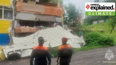
Kamchatka Earthquake Explained: The earthquake off the coast of Russia’s Kamchatka peninsula that has triggered tsunami warnings in Japan and the west coast of the United States and evacuations in Hawaii is one of the largest on record.
The 8.8 magnitude quake is the world’s biggest since the 2011 earthquake off the coast of Japan that generated a 50-foot tsunami wave and led to the Fukushima nuclear plant disaster. (More on the ‘magnitude’ of an earthquake below)
Kamchatka, an especially vulnerable region
Plate tectonics of the Kamchatka region
The southern portion of the peninsula sits above the area where the Pacific plate is subducting, or sliding below, the Okhotsk microplate to its north. Off the coast of Kamchatka, on the ocean floor lies the Kuril-Kamchatka Trench, formed as a result of this subduction. The trench is estimated to be almost 10 km deep at its deepest point.
These tectonic activities make the region seismically very volatile. As the Pacific plate moves under the Okhotsk plate at a rate of approximately 86 mm per year, ruptures along the megathrust boundary trigger periodic earthquakes and North Pacific Ocean tsunamis.
Part of the Pacific Ocean Ring of Fire
The Kamchatka peninsula region is part of the so-called Ring of Fire, which runs along the edges of the Pacific Ocean, which sees frequent and intense volcanic and seismic activity.
The Ring of Fire is shaped like a semicircle or horseshoe, and stretches for nearly 40,250 kilometres, tracing the meeting points of numerous tectonic plates, including the Eurasian, North American, Juan de Fuca, Cocos, Caribbean, Nazca, Antarctic, Indian, Australian, Philippine, and other smaller plates, which all encircle the large Pacific Plate.
The Ring touches more than 15 countries including the US, Indonesia, Mexico, Japan, Canada, Guatemala, Russia, Chile, Peru, and the Philippines.
What lies beneath in the Ring of Fire
The Ring of Fire witnesses so many earthquakes due to constant processes of tectonic plates sliding past, colliding into, or moving above or below each other. As noted above, it is seismic activity of this kind that triggered the July 30 Kamchatka earthquake and consequent tsunami.
As the edges of these tectonic plates are quite rough, they get stuck with one another, while the rest of the plate keeps moving. An earthquake occurs when the plate has moved far enough and the edges unstick on one of the faults.
The existence of volcanoes in the Ring of Fire is also due to the movement of tectonic plates. Many of these volcanoes have been formed through subduction, which, as explained above, is the process by which a heavier plate slides under the lighter plate as they collide, creating a deep trench.
Measuring the magnitude of an earthquake
The 8.8 magnitude earthquake of Wednesday qualifies as a “great” earthquake (of magnitude more than 8), only one of which is generally expected in the world in a year. It is the sixth-largest earthquake on the record, according to the US Geological Survey (USGS).
For an increase of 1 (whole number) in the magnitude of an earthquake, the seismic energy that is released increases by about 31.6 times, says USGS. This means that the 8.8 magnitude earthquake of Wednesday produces 31.6 times greater energy than an earthquake of magnitude 7.8 would have produced.
For perspective, the earthquake that struck central Myanmar this March, killing around 1,700 people, was of 7.7 magnitude. The strongest earthquake ever recorded was of magnitude 9.5, which struck off the coast of Chile in 1960, and killed more than 1,600 people, according to USGS.
The ‘magnitude’ is a quantitative measure of the scale of an earthquake. This differs from ‘intensity’, which is a qualitative measure of the shaking at a given location.
The motion of the ground during an earthquake is measured by an instrument called seismograph. The device is mounted on the Earth’s surface, so that when the ground shakes, the entire unit shakes with it, except for the mass on a spring. The recording device on the mass records the relative motion between itself and the rest of the instrument, according to USGS.