Stay updated with the latest - Click here to follow us on Instagram
Journalism of Courage

 Tourists swim in Acapulco, Mexico, Tuesday, Oct. 24, 2023. (AP Photo)
 On Tuesday morning, few meteorologists were talking about Tropical Storm Otis.
By Wednesday morning, a “catastrophic storm” had made landfall near a populated city in Mexico, drawing attention from around the globe.
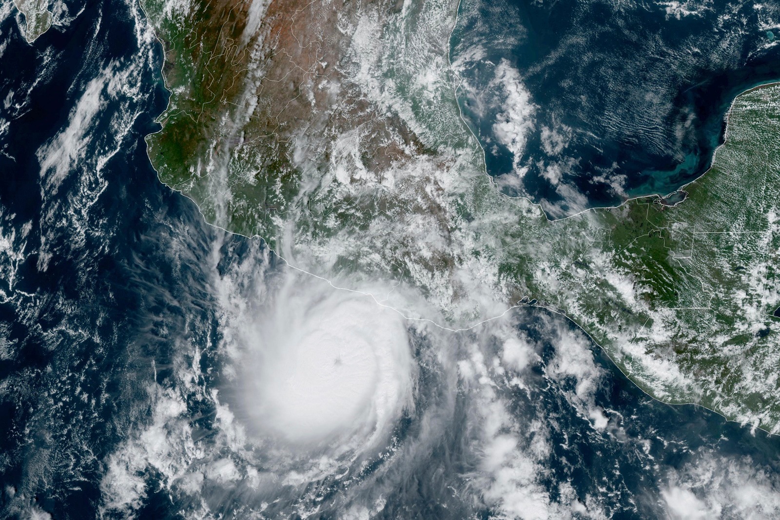
One of the more remarkable things about Otis was that “this rapid intensification was completely unexpected,” Tomer Burg, an atmospheric scientist, posted on X, formerly known as Twitter, on Tuesday evening as it was starting to become clear how quickly the storm was strengthening.
We can talk about statistics all day, but ultimately the biggest immediate concern is an *extremely* rapidly intensifying hurricane en route to landfall in Mexico, with little time to prepare for a landfall at this intensity. Hoping for the best for everyone in its path. pic.twitter.com/0q88mEjUat
— Tomer Burg (@burgwx) October 25, 2023
The storm began to organize itself Sunday morning, first as a tropical depression. At that time, forecast computer models didn’t show much to be concerned about. Forecasters with the US National Hurricane Center said that morning that “some slight strengthening” was possible over the following days. By Sunday evening, the computer forecast models were still not showing much.
AHORA: Empiezan a salir imágenes de los graves daños e inundaciones tras el paso del huracán Otis pic.twitter.com/IM4p5U2eMp
— BNO Noticias (@BNONoticias) October 25, 2023
A forecaster uses several tools to create a weather forecast, not just computer models. This is why meteorologists often preach that a computer model isn’t a forecast — forecasters create forecasts, they like to say. They also use satellite data and climatological norms to help form their predictions. They use satellite images to help estimate expected wind speeds and send hurricane hunter planes to the eye of a storm to collect real-time data.
Using some of those additional tools, forecasters had started predicting a stronger Otis than the models were suggesting — but they were still forecasting it to top out as a tropical storm.
 Waves break at the beach as Hurricane Otis barrels towards Acapulco, Mexico, October 24, 2023. (Reuters)
By Monday afternoon, the models started indicating that the storm could become a hurricane, and forecasters believed that with the abundant amount of moisture in the area and warm ocean temperatures, the storm would strengthen gradually.
On Monday evening, with Otis still a tropical storm, satellite images revealed a little feature that could mean that the storm was about to intensify very quickly. But the models still weren’t showing this, so forecasters continued to predict that the storm would be a weaker hurricane.
Global tools like the American forecast model and the European model haven’t always been great about predicting storms’ rapid intensification. Hurricane-specific models were created to help, and this year they have proved useful, including predicting the rapid intensification of Hurricane Idalia well before that storm reached Florida, giving people in the state more time to prepare.
 This satellite image provided by NOAA on Tuesday, Oct. 24, 2023, shows Hurricane Otis approaching Mexico’s Pacific coast near Acapulco. (AP/PTI)
Despite the improvement in these models, sometimes, as with Otis, they don’t forecast the increase in intensity, and we’re left with a “nightmare scenario,” which Eric Blake, a forecaster with the National Hurricane Center, wrote in his discussion Tuesday night as the storm approached southern Mexico and the intensity was becoming clear.
Later, in a post on X, he said he “thought long and hard about the word nightmare.” Ultimately, he decided that a storm growing from a tropical storm to a Category 5 hurricane headed toward a major city in less than a day fit that description.
Even when Otis was still a tropical storm, there was enough evidence for Mexico’s government to issue a hurricane warning for the coast, and hurricane forecasters were still expecting a stronger storm than the computer models were predicting.
On Tuesday afternoon, a hurricane hunter plane flew through the eye of the storm and found that its intensity was far stronger than the satellite estimates suggested.
 A man removes tables off a beach as Hurricane Otis barrels towards Acapulco, Mexico, October 24, 2023. (Reuters)
By Tuesday evening, with the storm clearly bearing down on Acapulco, the hurricane centre issued a rare special advisory forecast discussion. “Rapid intensification observed earlier today has continued,” the forecasters wrote. “The environment isn’t forecast to change much before landfall, and there are no signs of this explosive intensification stopping.”
It was a powerful warning to everyone in the storm’s path that this storm would be much bigger and much stronger than had been expected even a day earlier.
Importantes daños en Acapulco, Guerrero luego del paso del huracán Otis – Solo Acapulco pic.twitter.com/tsvUAQoZFC
— BNO Noticias (@BNONoticias) October 25, 2023
By Wednesday morning, Otis had made landfall as a Category 5 hurricane, leaving many wondering about the fate of Acapulco, and also why the forecast models had not been able to predict the future.
Over the coming days and weeks, scientists will be focused on answering that question.
Stay updated with the latest - Click here to follow us on Instagram