
 Weather Forecast Report, Cyclone Kyarr LIVE: The IMD said that cyclone ‘Kyarr’ is very likely to further intensify into an ‘extremely severe cyclonic storm during the next 24 hours.
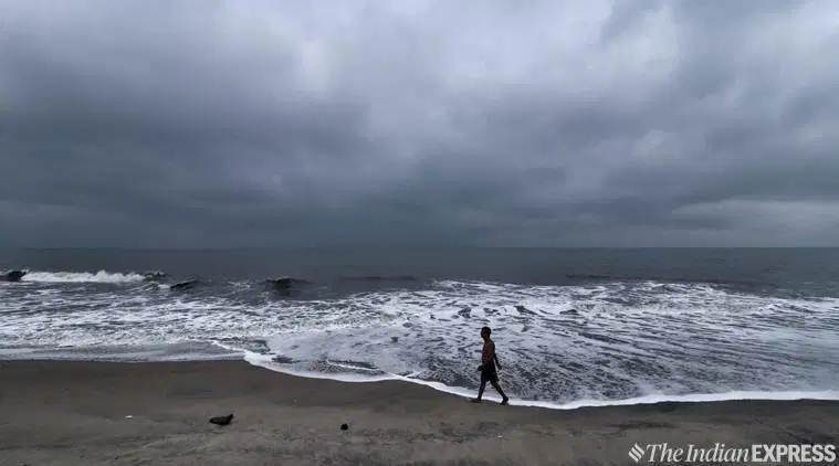
Cyclone Kyarr, Weather forecast Today: With cyclonic storm ‘Kyarr’ likely to intensify into an ‘extremely severe cyclonic storm’, the Indian Coast Guard has stepped up efforts for search and rescue operation on the Western Coast. The force told news agency ANI that a Dornier aircraft is undertaking frequent sorties to look for stranded fishing boats and their positions are being relayed to Coast Guard Ships operating at sea. The storm is likely to move towards Oman coast during the next 4-5 days, according to IMD.
Parts of south Gujarat and Saurashtra are likely to receive light to moderate rains and thundershower over the next four days with the cyclonic storm “Kyaar” hovering over the Arabian Sea, IMD said in its release on Saturday. The weatherman also forecasts heavy rainfall in Odisha, Assam and Meghalaya in the next 24 hours.
The met department said the sea will become “rough to very rough” along and off the south Gujarat coast during the next 24 hours until Sunday afternoon. The IMD advised fishermen not to venture into south Gujarat coast for the period due to the prevailing sea condition.
 The Met has also forecast heavy rains in Kolkata, North and South 24 Parganas, Murshidabad, East and West Burdwan, Nadia, Howrah, Hooghly, Malda, North and South Dinajpur districts of the state till Friday. (PTI)
So far, the Indian Coast Guard has rescued 19 fishermen and escorted more than 2100 fishing boats to safety at various ports in the West Coast.
Parts of south Gujarat and Saurashtra are likely to receive light to moderate rains and thundershower over the next four days with the cyclonic storm "Kyaar" hovering over the Arabian Sea, IMD said on Saturday. The met department said the sea will become "rough to very rough" along and off the south Gujarat coast during the next 24 hours until Sunday afternoon.
The India Meteorological Department (IMD) advised fishermen not to venture into south Gujarat coast for the period due to the prevailing sea condition. "Squally wind speed reaching 40-50 kmph gusting to 60 kmph is likely along and off south Gujarat coast during the next twenty-four hours. Sea will be rough to very rough along and off south Gujarat coast during next 24 hours. Fishermen are advised not to venture into south Gujarat coast during the next 24 hours," the IMD bulletin said. PTI
Acoording to IMD, rain/thundershowers are very likely to occur at many places over south interior Karnataka and at a few places over coastal Karnataka & north interior Karnataka. The sea condition is very likely to be high to very high over the east-central Arabian Sea during the next 24 hours and phenomenal there after. It will be rough to very rough along & off north Karnataka coast during next 24 hours, the weather agency reported.
Indian Coast Guard: We've stepped up efforts for search & Rescue operation on Western Coast in the wake of cyclone #Kyarr. Dornier aircraft is undertaking frequent sortie to look for stranded fishing boats & their positions are being relayed to Coast Guard Ships operating at sea.
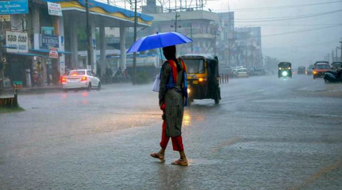
India Meteorological Department (IMD) on Saturday announced that cyclonic storm Kyarr is likely to enter into 'extremely severe' category. Earlier it was into very severe cyclonic storm category. The weather department has issued an advisory for fishermen not to venture into the sea due to bad weather. The tourists have also been asked to avoid coastal areas along Goa and Maharashtra.
In a relief, water levels on several stretches on Mumbai-Goa national highway between Canacona and Margao receded on Saturday though heavy rains continued to lash Goa on the fourth consecutive day. According to officials, the overall situation is normal in the coastal state which has been witnessing heavy rains since October 23.
In view of the India Meteorological Department's (IMD) prediction of heavy rains on Saturday, state authorities have issued a warning to fishermen and tourists against venturing into sea. "Water levels receded from several stretches on the national highway which were underwater on Friday," an official said on Saturday. The Mumbai-Goa national highway was inundated at several places between Canacona and Margao on Friday following the heavy post-monsoon rains.
The IMD predicted heavy rainfall at one or two places over North Goa and South Goa districts on Saturday. In neighbouring Maharashtra, a depression over east-central Arabian Sea intensified into cyclonic storm "Kyarr" in the early morning of October 25, which is likely to bring heavy showers in coastal districts of Ratnagiri and Sindhudurg. PTI
Skymet weather reported that a cyclonic circulation has formed over Southwest Bay of Bengal, resulting in moderate rain and thundershower activities during the past 24 hours. Rain is likely to increase in parts of Coastal Tamil Nadu.
Heavy rains lashed Goa for the fourth consecutive day. IMD said that state authorities have issued a warning for fishermen and tourists against venturing into the sea.
Cyclone Kyarr, with wind speeds touching 170-180 km per hour at its strongest, is the most powerful tropical cyclone to emerge near the Indian landmass after cyclone Fani, which caused large-scale devastation on the Odisha coast in May this year. However, Kyarr is likely to hit the Indian coastline, but swerve west-northwestwards and move towards the Oman coast. Read more
Every Tropical Cyclone basin in the world has its own rotating list of names. For cyclones in the Bay of Bengal and Arabian Sea, the naming system was agreed by eight member countries of a group called WMO/ESCAP and took effect in 2004. Read more here
Light to moderate rain is likely over North Coastal Karnataka, Goa and South Konkan for another 24 hours, Skymet Weather said.
Rainfall is likely to reduce over Maharashtra after the next 24 hours. However, as an after-effect of cyclone 'Kyarr', light to moderate showers would continue in some parts.
Skymet Weather Saturday said that due to the movement of cyclone 'Kyarr' towards the West Central Arabian Sea, moderate rain is likely in South Konkan and Goa, including Sindudurg, Ratnagiri and Panjim during the next 24 hours.
IMD said that heavy rain is likely at isolated places over major parts of Peninsular India during the next 48 hours and over parts of east and northeast India during the next 24 hours.
Severe Cyclonic Storm 'Kyarr', which intensified into a Very Severe Cyclonic Storm on Saturday, is very likely to further intensify into an Extremely Severe Cyclonic Storm during the next 24 hours. IMD said it is likely to move towards Oman coast during the next 5 days.
Severe Cyclonic Storm 'Kyarr' Saturday intensified into a Very Severe Cyclonic Storm and lay centred over east-central Arabian Sea, about 270 km to the west-southwest of Ratnagiri (Maharashtra), 360 km south-southwest of Mumbai and 1,780 km east-southeast of Salalah (Oman), IMD said.
Rain may dampen Diwali celebration in Mumbai, Palghar and Thane. IMD predicted that post-monsoon showers would continue till Sunday due to a "deep depression" or an intense low-pressure system formed over the Arabian Sea. Read more here
IMD Friday said that cyclonic storm Kyarr is likely to bring heavy rains in coastal Maharashtra. Palghar district collector issued a warning to fishermen to not venture out in the sea. District fisheries department officials said that 1,378 out of 1,411 boats which had sailed off Palghar coast returned and efforts were on to bring the rest 33 boats safely to the shore.
IMD has predicted light to moderate rainfall at most places with heavy falls at isolated places is very likely over coastal districts of Karnataka, Goa and south Konkan during next 12 hours. Isolated heavy rainfall also very likely over north Konkan during same period.
Cyclone 'Kyarr' which has intensified into a cyclonic storm lies close to Ratnagiri and Mumbai, over the east-central Arabian sea.
Cyclonic storm Kyarr batters Goa, disrupts normal life.
At least three persons were killed and four others injured as heavy rain triggered by a low-pressure area over the Bay of Bengal lashed Odisha for the third day in a row throwing life out of gear at several places, officials said on Friday.
The rain battered coastal, southern and central Odisha for the past two days and eight districts received over 100 millimetres of rain since Thursday.
All the casualties also occurred on Thursday and due to wall collapse in three districts, officials said. (PTI)
Cyclonic storm Kyarr lay centres over the Arabian Sea at 11:30 am. It is likely to intensify in the next 12 hours and move nearly northwards and then west-northwestwards towards Oman coast during next five days.
Heavy rain lashed several places of West Bengal till Friday morning since Thursday and the Met department forecast more downpour in the state owing to a low pressure area in south Odisha and West Central Bay of Bengal.
The weatherman, however, held out a ray of hope for good weather on Kali Puja and Diwali to be celebrated in the weekend, forecasting a clear sky from Saturday afternoon.
The Met department forecast heavy to very heavy rain in East and West Midnapore, South 24 Parganas districts of Gangetic West Bengal.
Heavy rain is likely at one or two places over districts of Sub-Himalayan West Bengal and in Howrah, North 24 Parganas, Murshidabad, Nadia, Birbhum, Hooghly and East Burdwan districts of Gangetic West Bengal, the weatherman said. (PTI)
According to Oman Meteorology, the tropical storm is 1,500 km away from Ras Madrakah and there are no direct effects predicted on the coasts of the Sultanate within the next 3 days.
The weather agencies in Oman are on high alert as tropical storm Kyarr moves towards the Oman coast later today. Oman's Public Authority for Civil Aviation, which is monitoring the cyclonic storm, said in a statement, “Tropical conditions east of the Arabian Sea have evolved into a tropical storm called Kyarr with wind speeds (34-45) knots around the center.”
However, weather across most parts of the state is expected to remain clear on Friday.
Heavy rains continued to pound Goa for the third consecutive day on Friday, throwing life out of gear with no immediate respite in sight.
The Indian Meteorological Department’s (IMD) Goa observatory also issued a fresh warning and advised tourists to stay indoors and asked fishermen to avoid venturing into the sea in view of bad weather conditions. Read more
A red alert, indicating 'extremely heavy rainfall', has been issued for Sindhudurg district, which would mean precipitation of 204.5 mm rainfall in 24 hours, it said.
Cyclone Kyarr would result into gale winds, reaching the speed to 85 kmph and by Saturday it would become 110 kmph, the IMD said. (PTI)
Fishermen along and off the Maharasthra, Goa, Karnataka, Gujarat and northeast Arabian sea are advised not to venture in Arabian Seat till October 28.
Forecast track and intensity of Cyclone Kyarr.
Two days before Diwali, the national capital's air quality dropped to season's worst on Friday, with the decreased wind speed leading to accumulation of pollutants and affecting dispersion, news agency PTI reported. Most of the places in the national capital recorded the AQI in the "very poor" category, while the situation inched towards "severe" in some areas.
Flood-like situation in Sanakhemundi block in Ganjam district following heavy rainfall in the region.
"Deep Depression over the Arabian Sea intensified into Cyclonic Storm 'KYARR' at 0830 hrs IST of 25th Oct. It is very likely to move west-northwestwards towards Oman coast during next 5 days with gradual intensification," the IMD said in a tweet.
The India Meteorological Department Friday said that the Deep Depression over the east-central Arabian Sea intensified into a cyclonic storm ‘Kyarr’ and lay centered about 240 km west-southwest of Ratnagiri in Maharashtra.
Dakshina Kannada deputy commissioner Sindhu B Rupesh Thursday declared a holiday for schools and Scolleges in the district on Friday in view of the IMD forecast.
Citing rough weather conditions, IMD's Goa observatory on Thursday issued an advisory saying tourists should avoid visiting the coastal state till October 27. Goa was put on red alert for Thursday, as it has been receiving heavy to very heavy showers because of a cyclonic depression in the Arabian Sea.
With a low-pressure area over south Odisha headed towards north north-westwards, the Met department on Thursday forecast heavy rain in some places of West Bengal till Saturday morning. Heavy to very heavy rain will occur at one or two places in East and West Midnapore, Jhargram, Birbhum, Bankura and Purulia districts of Gangetic West Bengal, the MeT said in its forecast.
It said that heavy rain is likely in Kolkata, North and South 24 Parganas, Murshidabad, East and West Burdwan, Nadia, Howrah, Hooghly, Malda, North and South Dinajpur districts of the state till Friday. (PTI)
The India Meteorological Department has forecast light to moderate rainfall at most places with heavy to very heavy falls at isolated places very likely over coastal districts of Karnataka, Goa & south Konkan during next 24 hours.
Meteorological Centre, Goa: A deep depression approximately 235.7 kms from Panaji is expected to concentrate into a cyclonic storm and move north-northeastward.