© IE Online Media Services Pvt Ltd
Latest Comment
Post Comment
Read Comments

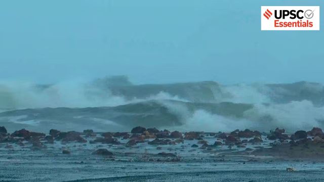 Rough sea ahead of the landfall of Cyclone 'Montha', at Kauda beach in Kakinada, Andhra Pradesh. (PTI)
— Abhinav Rai
The landfall of Cyclonic storm Montha off the coast of Andhra Pradesh last month caused severe damage to crops, power supplies, roads, and transport infrastructure due to high wind speeds (approximately 100 km/h) and heavy rainfall.
It damaged more than 87,000 hectares of crops in Andhra Pradesh alone, with significant impacts also reported in Odisha, Tamil Nadu, Telangana, Bihar, Jharkhand and Uttar Pradesh. The total damage has been pegged at 6,384 crore and Andhra Pradesh has sought 901.4 crore as immediate relief from the centre.
According to a study on extreme weather events (heatwaves, cold waves, tropical cyclones, floods, lightning, heavy rainfalls, etc.), tropical cyclones alone were responsible for 28.6 per cent of deaths between 1970–2019. The study titled, An Assessment of Long-term Changes in Mortalities due to Extreme Weather Events in India: A Study of 50 Years’ Data, 1970-2019, is based on data from the India Meteorological Department (IMD).
A new report, Climate Risk Index 2026, also ranked India ninth among the countries most affected by extreme weather events, including cyclones, between 1995 and 2024. Let’s understand what a cyclone is, its different types, formation, and what makes India vulnerable to tropical cyclones.
Cyclones are a type of atmospheric disturbance where wind circulates around a low-pressure centre. The source of energy for the genesis, development, and intensity of the tropical cyclones is the heat and moisture generated by the warm ocean waters.
In the Northern Hemisphere, the direction of wind circulation is anticlockwise, while in the Southern Hemisphere, it circulates clockwise. Based on their location, cyclones are classified as tropical cyclones (forming over warm tropical oceans) and extratropical cyclones (occurring in temperate and high-latitude regions).
Tropical cyclones are known by different names around the world – Hurricanes in the Atlantic, Typhoons in China, and Willy-willies in Australia. Most of the Indian landmass and the surrounding North Indian Ocean is located between the equator and the tropic of cancer, thus prone to some of the most devastating tropical cyclones.
Tropical cyclones originate over warm oceans within the tropics (5°-20° N & S latitudes). Their formation requires:
1. Sea Surface Temperature (SST) of about 27℃ or more (up to a depth of 60–70 meters).
2. An abundant supply of warm and moist air.
3. The Coriolis force (responsible for wind’s anticlockwise direction in the Northern Hemisphere’s low-pressure systems).
4. Pre-existing weak low pressure area.
These cyclones further intensify when there exists an anticyclonic circulation at an elevation of 9-15 km above the surface disturbance. It accelerates the upward movement of air, further deepening the low-pressure system.
The centre of a cyclone is characterised by extremely low pressure, calm with subsiding air. This region is also known as the ‘eye’ of the cyclone. Around this is the ‘eye wall’, where warm spiralling air makes an upward movement, reaching up to the tropopause.
Cyclones originate over oceans and generally reach the coast, where it is referred to as the ‘landfall’ of the cyclone. In other words, landfall is the event of a tropical cyclone coming onto land after being over water.
Over oceans, these cyclones become more vigorous and move with very high velocity (180-400 km/h) due to continuous moisture supply. However, after the landfall, the moisture supply is cut off, and they gradually dissipate while moving over interior continents. This is why most devastating effects are felt mostly in the coastal regions.
The average diameter of these storms is between 600 to 1200 km. These cyclones advance with varying velocities based on their strength. Weak cyclones move with about 32 km/h, while Hurricanes can attain up to 180 km/h or even more. When the sustained wind speed reaches 34 knots (62 km/h) or more, that cyclone gets a unique name.
These atmospheric disturbances play a vital role in the exchange of heat, humidity, and precipitation between different latitude zones. In India, cyclones originating from the Arabian Sea and the Bay of Bengal influence weather conditions mainly between April and December.
They can cause severe and large-scale destruction through high speed winds, very heavy rainfall, and storm surges (tidal waves) in the oceans. These cyclones can cause loss of life, inflict severe damage to infrastructure, including buildings, transport systems, water and power supply.
These Ocean-Atmosphere interactions are a two way process. Warm oceans provide favourable conditions for the genesis and evolution of cyclones. These cyclones then pull colder and saltier water from deeper layers up to the ocean surface. This cyclone-induced cooling depends upon the speed of the cyclone, wind power, ocean stratification, and sub-surface conditions.
This interaction between oceans and atmosphere also has a biological response from the ocean in the form of large chlorophyll blooms due to cyclones impacting marine productivity and the carbon cycle.
India has a long coastline, shallow continental shelf, high population density and flat coastal terrain, which make it vulnerable to tropical cyclones originating in the North Indian Ocean (NIO). The NIO is among the six major regions of the world where tropical cyclones mostly develop.
Nearly 8 per cent of India’s geographical area, containing 13 coastal states and union territories, is vulnerable to severe tropical cyclones year after year. With climate change induced sea-level rise, this vulnerability of the coastal population is expected to increase further.
Historically, these cyclones have resulted in loss of lives and livelihoods, and severe damage to properties. One of the most notable catastrophic events in recent history was the Super Cyclone of Odisha in 1999 (October 28-29). It claimed 10,000 lives, damaged 275,000 houses, making more than 1.67 million people homeless, along with the loss of livestock.
Around 6-7 per cent of the global tropical cyclones occur in the North Indian Ocean annually. Some of them are very devastating. Studies indicate a 1.2–1.4°C increase in the sea surface temperatures (SSTs) of the Arabian Sea compared to four decades ago. This rise in temperature favours the rapid intensification of cyclones, often not providing sufficient time for evacuation and disaster management on the ground.
After the Super Cyclone, Odisha established the Odisha State Disaster Management Authority in 1999 itself – well before the establishment of the National Disaster Management Authority (NDMA) in 2005. To further reduce the vulnerability of the coastal population, the National Cyclone Risk Mitigation Project (NCRMP) was launched in 2011 by the NDMA.
Improved climatic forecasting coupled with better preparedness has helped in effectively decreasing the loss of lives, as seen in recent years. Forecasting capabilities for cyclone tracks and landfall positions have also improved significantly. However, predicting the intensification of cyclones with sufficient lead time, especially when it is rapid, is still a challenge, mainly due to gaps in in-situ ocean observations.
To further enhance the preparedness and mitigation strategies, an accelerated shift from evacuation-centric responses to resilience-oriented systems is needed. Capacity building of communities is also crucial, as they are the first responders in time of disasters. Policies promoting the Early Warning Dissemination System (EWDS) and Community Based Disaster Risk Management (CBDRM) practices can further help in timely evacuation before landfall of the cyclone.
Cyclone Risk Mitigation Infrastructure (CRMI) enhances the preparedness and mitigates the vulnerability of coastal communities through investments for the construction of multi-purpose cyclone shelters (MPCS), roads, bridges, underground electric cabling and saline embankments. A holistic cyclone disaster management approach should focus on being proactive in implementing disaster preparedness and risk reduction activities.
What are cyclones? How and where are they formed? What are their consequences? Explain with examples.
Discuss the difference between tropical and extratropical cyclones with examples.
Explain how ocean warming in the Arabian Sea has influenced cyclone patterns and intensities.
How do Early Warning Dissemination Systems (EWDS) and Community-Based Disaster Risk Management (CBDRM) contribute to disaster preparedness? Discuss the need for integrating local communities into cyclone disaster risk reduction frameworks.
Suggest a comprehensive strategy for improving India’s resilience against tropical cyclones.
(Abhinav Rai is a Doctoral candidate at the Department of Geography, Delhi School of Economics, University of Delhi.)
Share your thoughts and ideas on UPSC Special articles with ashiya.parveen@indianexpress.com.
Subscribe to our UPSC newsletter and stay updated with the news cues from the past week.
Stay updated with the latest UPSC articles by joining our Telegram channel – IndianExpress UPSC Hub, and follow us on Instagram and X.

Read UPSC Magazine