© IE Online Media Services Pvt Ltd
Latest Comment
Post Comment
Read Comments

 India has faced growing vulnerability to the rising frequency and intensity of extreme weather events in recent years, such as more frequent and severe floods, landslides, cloudbursts, and mudslides. (Express photo by Nirmal Harindran)
— Abhinav Rai
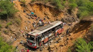
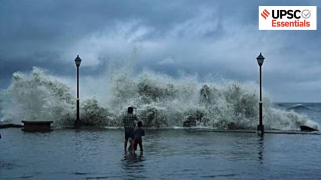
In recent years, India has faced growing vulnerability to the rising frequency and intensity of extreme weather events, such as more frequent and severe floods, landslides, cloudbursts, and mudslides. These disasters cause significant loss of lives and livelihoods, damage infrastructure, and affect ecology and public health.
The Intergovernmental Panel on Climate Change in its sixth Assessment Report (AR6) has projected that in the coming years, India will experience intensified summer monsoons, increased heavy rainfall events, more frequent floods, and prolonged, intense heatwaves.
A report by the Centre for Science and Environment (CSE) has already revealed a disturbing trend: India experienced extreme weather events on 322 days in 2024, 318 days in 2023, and 314 days in 2022. These extreme events include heavy rain, floods, landslides, heat and cold waves, cyclones and lightning.
According to the India Meteorological Department (IMD), at least 1,528 casualties occurred during June-September monsoon season, with Madhya Pradesh, Himachal Pradesh, and Maharashtra being among the worst-affected states. In 2024 alone, 3,472 people lost their lives, 67,399 livestock perished, 4.07 million hectares of cropped land were affected, and 2.9 lakh houses were damaged due to extreme events.
These extreme weather events and their impact draw attention to India’s climate resilience, especially through the integration of modern technologies such as Remote Sensing (RS) and Geographic Information Systems (GIS), which have become essential for effective management, adaptation, and mitigation efforts.
First, let’s have a brief spatial overview of extreme events and their impact.
The IPCC defines extreme weather events as ‘an event that is rare at a particular place and time of year’. The spatial distribution of these extreme events has been staggering. The monsoon season this year brought catastrophic events like the Wayanad landslide, flash floods in Himachal Pradesh and Jammu, and cloudbursts and mudslides in Dharali, Uttarakhand, claiming multiple lives. States like Punjab, Bihar and Assam experienced severe floods, while cities like Mumbai, Delhi and Bengaluru faced waterlogging.
Marathwada region, which has historically been characterised by drought conditions, received 128 per cent of its normal monsoonal rainfall between June and September this year. The heavy rains have led to loss of lives, crops, and livelihoods. Meanwhile, the intensity and frequency of heatwaves continue to escalate, especially across the heat core zone that encompasses the northern plains and central India. This heterogeneity in spatial distribution stems from complex interactions between local topography, atmospheric patterns, and global climate drivers.
A good monsoon is critical for India’s agricultural production, replenishment of surface and groundwater reserves, and hydro-electricity generation. About 75 per cent of the country’s total rainfall comes during the monsoon season (June-September). However, in recent years, the temporal and spatial distribution of rainfall has been unusually intense and unpredictable in most parts of the country.
Climate change and recent warming are causing these erratic and extreme precipitation events, resulting in more frequent and severe floods and other extremes. The adverse impact of these events is further exacerbated due to unplanned urbanisation, deforestation, local topography, inadequate infrastructure, and poor socio-economic conditions of some communities.
Flash floods and landslides are wiping out years of investment in public infrastructure like roads and hydropower. Beyond losses of life and property, these disasters inflict psychological trauma on affected communities, which is usually overlooked in policy discussions. Moreover, rising temperatures and heatwave-like conditions directly affect labour productivity and increase energy demands. Our healthcare infrastructure requires special attention in the wake of increasingly warming conditions.
But there are various challenges in monitoring and mitigating these extreme events. These include inconsistent standards for reporting these events across states and Union Territories, fragmented information, and gaps in loss and damage assessment, resulting in significant underreporting of climate impacts.
Further, the inadequate number of weather monitoring stations, especially in the Himalayan regions and the limited availability of high-resolution satellite data for researchers hinder the accurate disaster assessment and spatial coverage.
Against this backdrop, the integration of modern technologies such as Remote Sensing (RS) and Geographic Information Systems (GIS) becomes essential for effective disaster management.
Remote sensing (RS)
RS is the process of acquiring information about the Earth’s surface without being in direct physical contact, generally through satellites, drones, or aircraft-based sensors. The process operates on the principles of electromagnetic radiation, as all matter which has a temperature higher than absolute zero (-273 degrees Celsius) radiates continuously.
Through RS, we can capture data in various spectral bands, even those beyond the visible range in thermal, infrared, and microwave ranges.
Geographic Information Systems (GIS)
These are computer-based systems that help us organise, store, interpret, and analyse the spatial data. Historical data from remote sensing satellites, such as from Landsat and LISS satellites, can be integrated with GIS to track environmental changes over time, identify trends and patterns of land use and land cover changes, which is also crucial for predictive modelling.
These technologies have a range of applications, including hazard susceptibility and vulnerability zone mapping, detecting heat anomalies, flood extent, forest fires, vegetation health, cryosphere monitoring, and urban expansion, among others.
Together, RS and GIS act as the eyes and brain of modern disaster management strategies. They can provide real-time locational intelligence, which is crucial in monitoring efforts. Drones are also an RS instrument which are helpful for spatial insights of local or specific areas.
Initiatives like Mission Mausam also aim to integrate next-generation radars and satellite systems with a GIS-based automated Decision Support System for real-time data dissemination. This integration will increase accessibility to environmental data and help governments to formulate evidence-based policies and plans for disaster mitigation.
Recently, NASA and ISRO jointly launched the NISAR satellite, which will provide free data worldwide. NISAR’s radar systems will scan nearly all the planet’s land and ice surfaces twice every 12 days, tracking shifts as slight as a centimetre, marking a breakthrough in predicting natural disasters and tracking climate change impacts.
Despite the recurring nature of such extreme events, our policy response remains largely reactive. Therefore, there is an urgent need to shift from disaster response and post-disaster relief towards an approach focussed on risk reduction, preparedness, and community resilience-building. This also aligns with the Sendai Framework for Disaster Risk Reduction (2015-2030), which encourages “a shift from managing disasters to managing disaster risks”.
Moreover, there is a need for more satellites with higher spatial resolution and frequent revisit capabilities for better early warning systems and real-time monitoring. Currently, data on these extreme events is fragmented, underlining the need for an integrated data structure that not only provides the number of events but also enables real-time monitoring of loss and damage.
As these disasters transcend administrative boundaries, policies need to be framed around the larger geographical realities. To manage and mitigate the adverse impacts of climate change, India needs a comprehensive and inclusive adaptation plan that encompasses all regions and sectors. Integration of technologies like RS and GIS and AI would certainly play a transformative role in this.
Only through such comprehensive integration can India build the resilience necessary to protect its citizens and economy from the mounting challenges of climate change.
What trends have been observed in the frequency and intensity of extreme weather events in India in recent years?
Why is it important to shift India’s disaster management approach from post-disaster relief to risk reduction?
Discuss the role of data integration and accessibility in improving early warning and disaster response systems.
How can RS, GIS, and AI together revolutionize climate adaptation and disaster resilience planning?
How can initiatives like Mission Mausam and NISAR enhance India’s capacity for real-time disaster response?
(Abhinav Rai is a Doctoral candidate at the Department of Geography, Delhi School of Economics, University of Delhi.)
Share your thoughts and ideas on UPSC Special articles with ashiya.parveen@indianexpress.com.
Subscribe to our UPSC newsletter and stay updated with the news cues from the past week.
Stay updated with the latest UPSC articles by joining our Telegram channel – IndianExpress UPSC Hub, and follow us on Instagram and X.

Read UPSC Magazine