Journalism of Courage
Premium
This is an archive article published on August 11, 1998
ISRO scientists look forward to leaps in cartography
AHMEDABAD, Aug 10: India is poised to achieve self-reliance in cartography (the science of mapping) in the year 2000 when the CARTOSAT-I ...
Written by Deep Joshi
August 11, 1998 12:00 AM IST 4 min read


AHMEDABAD, Aug 10: India is poised to achieve self-reliance in cartography (the science of mapping) in the year 2000 when the CARTOSAT-I satellite will be launched by the Indian Space Research Organization (ISRO) from its SHAR centre located north of Chennai. Another satellite, CARTOSAT-II will be launched in 2002 from the same centre.
"It will be a unique achievement of its kind for the country", Head of the Ahmedabad-based Space Application Centre’s Satellite Photogrammetry and Digital Cartography department, Dr P K Srivastava told Express Newsline.
"It will be an extraordinary achievement not only because the mapping process, which is done manually, will be speeded up manifold with the help of satellites, but because the development process will be also speeded up”, he explained.
Story continues below this ad
Moreover, Srivastava said, satellite technology has twin advantages. "Besides quickly mapping even the intractable areas like mountains and deserts, we will also be able to save crores of rupees that are at present spent on manual surveys of the country’s land mass.".
"The CARTOSAT-I project has been approved by the Government", Srivastava said. He said, "ISRO has also completed the study for the CARTOSAT-II, which will soon be sent to the Government for its approval".
Manual mapping, according to the SAC scientists, is a problem the world over, much bigger in the developing countries than in the developed countries. But in India’s context, the problem is going to be resolved as the twin satellites, scheduled to be launched in the beginning of the next millennium, will be having very high resolution. So much that CARTOSAT-I will be able to map upto 2.5 metres of the land mass. Resolution of the CARTOSAT-II will be still higher as it will be able map even one metre of the mapped area.
Some countries, including France, have the technology of satellite mapping but don’t have the required land mass to make the maximum use of it except exporting data to other countries. Some have large land mass but don’t have the technology. But India is "unique" in that it is going to have technology that it can utilise fully by mapping the country’s vast land area, besides exporting the data to other countries. Moreover, as Srivastava puts it, "satellite data is the cheapest solution for mapping large geographical regions like India" although he adds in the same breath that building the satellites and running the programme is expensive.
Story continues below this ad
However, the technology has wider uses. One of them is quick updating of maps. According to scientists, the absence of satellite technology means that several towns and roads which have come up in different areas of the country as part of development activities, have not been mapped properly.
"All these development activities, which the survey agencies would take years to put on the map, will be recorded by satellites within a few months’ time, thus helping the planners and engineers speed up the development process", says Srivastava.
Besides that, he says, since the CARTOSAT satellites will be sending three-dimensional images of the ground, it will be easier for the agencies concerned to make fast and accurate assessment of the flood-affected zones. Besides that, they will also be able to assess in advance the impact of big projects on the environment.
Another major advantage, according to Srivastava, is that India can export satellite data to other countries to recover the money spent in the fabrication and launching of the twin satellites.
Advertisement
Live Blog
PHOTOS


Top Stories


Advertisement
Must Read
Sports'This is exactly the pitch we wanted; if you don't play well, this is what happens: India head coach Gautam Gambhir dismisses talks surrounding Eden pitch after collapse


TechnologyHow screenless wearables like Whoop and Oura ring are making discreet fitness tracking popular


Advertisement
Buzzing Now
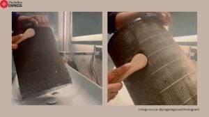
TrendingDelhi woman gives air purifier a ‘spa day’ after it turns black from pollution; viral video alarms netizens: ‘So harmful to stay indoors’

Trending‘Swiggy dad’ goes viral for teaching daughter between deliveries; inspires the Internet: ‘Real life hero’

TrendingAkon ‘harassed’ on stage in Bengaluru, viral video shows fans pulling singer’s pants during concert: ‘India has no respect for any artist’


- 01
- 02
- 03
- 04
- 05
Advertisement