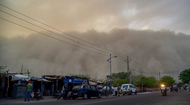
 Thunderstorm alert LIVE UPDATES: A dust storm is seen building up over the city of Bikaner on Monday. In a fresh advisory by the India Meteorological Department (IMD), dust storm and heavy rain likely at isolated places in Uttar Pradesh, Jammu and Kashmir, Punjab, Himachal Pradesh, western Rajasthan and states in North-east. (PTI photo)
Thunderstorm alert LIVE UPDATES: Several parts of north India are likely to witness thunderstorm, accompanied by gusty winds and moderate squall on Tuesday. Wind speed is expected to vary between 50 and 70 km per hour, according to the India Meteorological Department (IMD). IMD issued an alert on Monday saying “under the influence of a western disturbance, a cyclonic circulation over Haryana and a west-east tough from northwest Rajasthan to central Madhya Pradesh in lower levels” will bring light to moderate rainfall in north India. The prediction comes a week after a deadly thunderstorm killed at least 124 people and injured more than 300 in Uttar Pradesh and Rajasthan. In the next 48 hours, parts of Jammu and Kashmir, Himachal Pradesh, Uttarakhand, Punjab, Haryana, Chandigarh and Delhi and western Uttar Pradesh are expected to witness heavy to moderate rainfall. The wind speed of 50-70 kilometers per hour has been predicted. Also READ | North India could witness thunderstorm, gusty wind | Also Read | Thunderstorm alert: What Delhi should know and prepare for
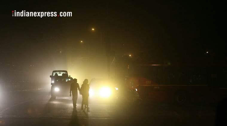 Dust storm over Delhi on Monday night (Express Photo by Amit Mehra)
The parapet of a building collapsed in Badarpur area of south east Delhi on Tuesday night, injuring three children and a woman. A Delhi Fire service official told PTI that the incident took place apparently due to high-speed winds.
Thunderstorm with rain and gusty winds would occur over and adjoining areas of most parts of Delhi and NCR including Bhiwani, Rohtak, Bagpat, Panipat, Meerut, Muzaffarnagar, Bijnor in the next two hours: IMD
Delhi government had put search and rescue teams on standby in the wake of the weatherman issuing a warning of heavy rain and thunderstorm. The traffic police has alerted their field formations to be ready to remove obstacles such as fallen trees and asked commuters to check weather conditions before travelling.
According to IMD, Uttarakhand will continue to experience thunderstorms in the next 24 hours.
Thunderstorm with rain and strong winds would occur over NCR including Hisar, Kaithal, Jind, Kurukshetra, Karnal during next two hours: IMD
Heavy rains and thunderstorm are likely to hit the national capital tonight, according to the MeT department. The maximum temperature was recorded at 34.7 degrees Celsius today, four notches below normal while the minimum settled at 22 degrees Celsius, norm l for this time of the year, a MeT official said.
The humidity levels oscillated between 54 and 28 per cent.
Thunderstorms and lightning on May 2-3 killed at least 134 people and injured more than 400 in five states, including the hardest-hit Uttar Pradesh, the Home Ministry said today. The highest 80 people were killed in Uttar Pradesh and nearly 100 others were injured in the state. A majority of the deaths and injuries were reported from the Agra region, a home ministry spokesperson said, giving the latest figures.
(Source: ANI)
(Express photo by Pradeep Kumar)
(Express photo by Pradeep Kumar)
Express photo by Pradeep Kumar
(Source: ANI)
(Source: ANI)
Thunderstorm and hailstorm alert issued for Uttarkashi, Chamoli, Rudraprayag, Pithoragarh districts for the next few hours.
The meteorological department has warned that thunderstorm accompanied with squall and wind speed of 50-70 km/hour may hit isolated places in Sikar, Ajmer, Nagaur, Jaipur, Dausa, Alwar and Tonk districts from 9 am–11 am today.
The weather office has forecast dust storm, thunderstorm or light rains in 26 out of 33 districts of Rajasthan today.
Heavy winds hit Ajmer and some areas of Jaipur this morning while a dust storm hit Bikaner and nearby region last night.
Gusty winds swept parts of Rajasthan overnight and this morning, affecting normal life, weather officials said. No casualties have been reported so far.
An advisory was issued to avoid travelling to the high hills of Kullu, Sirmaur, Chamba, Lahaul and Spiti and Kinnaur districts as chances of snow and rain are high over the next 24 hours, IANS quoted a government spokesperson as saying on Tuesday morning. Kullu Deputy Commissioner Yunus Khan told IANS that tourists and locals bound for the Rohtang Pass, some 52 km from Manali, were not allowed to go beyond Marhi, due to continuous snowfall that has resulted in snapping of road links leading to the pass.
Meanwhile, the Himachal Pradesh government on Tuesday advised locals and tourists not to travel towards the higher reaches as moderate snowfall and rains continued across the state.
Monday's maximum temperature in Delhi was recorded at 39.6 degrees, while the minimum temperature settled at 24 degrees.
"The day ahead will be cloudy. Rain and thunderstorm accompanied with squall is likely to occur later in the day," an India Meteorological Department (IMD) official said.
The minimum temperature was recorded at 25.8 degrees Celsius and the maximum temperature was likely to hover around 41 degrees Celsius. The humidity at 8.30 a.m. was 58 per cent.
The national capital woke up to a cloudy morning on Tuesday with predictions of rain and thunderstorm, a Met official said.
The weather office also warned that thunderstorms, squalls and gusty winds are likely to hit many parts of India, including Delhi, till Friday even as the mountains of Himachal Pradesh received fresh snowfall.
In a weather warning bulletin, the India Meteorological Department (IMD) said the states likely to be affected by thunderstorms and gusty winds are Uttar Pradesh, Bihar, West Bengal, Sikkim, Odisha, Assam, Meghalaya, Nagaland, Manipur, Mizoram, Tripura, Karnataka and Kerala.
All the public and private schools in Ghaziabad will remain closed on Tuesday in view of the adverse weather expected, it was announced on Monday. In an order, District Magistrate Ritu Maheswari said that in view of the forecast for a thunderstorm on Tuesday, private and government schools and colleges shall remain closed.
Strong surface winds followed by hail storm turned the weather in Uttar Pradesh's Agra on Monday prompting an alert from the Met office for the next 48 hours till Wednesday. District Magistrate Gaurav Dayal issued a detailed advisory with "Dos and Don'ts", gearing up for another deadly storm as the Met warned of high-velocity winds and heavy showers in the region.
"Chances of severe Dust storm over Delhi and NCR have decreased. We expect one or two spells during afternoon and evening. Winds will be 50 to 60 Kmph gusting to 70 Kmph," said Mahesh Palawat, Vice President, Weather and Climate Change, Skymet Weather.
Meanwhile, Badrinath received fresh snowfall this morning, 2 inches of snow covers the area. Hemkund received fresh snowfall too. Badrinath Yatra underway.
The commuters have been advised to take shelter under concrete structures. Drivers have been advised to use dippers or parking lights while driving. The advisory says that commuters should “keep themselves updated about weather conditions and plan their journey accordingly”.
The revenue department of the Delhi government has issued directions to all district officers and said water and power utilities would also keep restoration teams ready.
Delhi traffic police has asked commuters to check weather conditions before travelling.
READ | Delhi braces for thunderstorm: Evening schools shut, Metro could be hit today
A dust storm is a strong, turbulent wind that carries clouds of fine dust, soil, and sand over a large stretch, which mainly occurs in arid and semi-arid regions. In case of a dust storm, due to excessive heating, the water from the clouds evaporates before it could land. So soil is dry and the severe winds lift this soil up to 500 metres above the land. While wind speed is normally around 50 kmph in a thunderstorm, in case of dust storm, it reaches up to 100 kmph and in some cases it can touch 130 kmph, making conditions severe.
Kamal Kishore said the NDMA had prepared videos on precautions to be taken during lightning. These videos were in English and Hindi and could be translated into local languages. There are some other videos too!
National Disaster Management Authority (NDMA) member Kamal Kishore said there is a need to “vigorously” push for creating awareness among people. “The NDMA provides normative guidance than needs to be then adapted to the local context,” he said.
UP Chief Minister Yogi Adityanath, who was campaigning in Karnataka when the storm caused havoc in the state, had blamed the weather department for not providing adequate information. Rajasthan authorities had also said that information provided by the weather monitoring agency was not “specific”.
A senior IMD official told The Indian Express that “written observations on the steps taken to issue warnings” had been sent to the Centre. “The IMD is not to be blamed… We provided a warning of up to five days before the May 2 storm,” the official said.
The Centre has asked IMD to explain why its forecasting mechanisms failed to prevent the deaths. But the meteorological agency maintained it had called up chief secretaries of the two BJP-ruled states, but they had “failed to disseminate the information.” The IMD also said that its role was to forecast and issue alerts, while it was up to the state authorities to take it to the “last mile” and alert people.
Also Read | Centre, IMD lock horns over storm deaths in Rajasthan, UP on May 2
Meanwhile, a blame game has started between the Centre and the India Meteorological Department (IMD) over alleged lapses in the weather warning agency’s early warning mechanism, days after dust storms whipped through parts of Rajasthan and Uttar Pradesh, killing over a hundred people.
The IMD on Monday held a meeting to review preparedness.
The Delhi Metro, too, has decided to exercise caution in running trains. “If wind speed is reported in the range of 70-90 kmph, then train movement will remain normal but trains will enter with a restricted speed of 40kmph or less at platforms on elevated sections. If wind speed is more than 90kmph, then trains will be put oh hold at platforms… no train will enter the platform with a speed of more than 15kmph. Normal movement of trains will be restored once the wind speed is less then 85kmph for continuous five minutes,” the DMRC said.
Delhi Police, meanwhile, has asked those in trouble to call any of their helplines or to send a message to their Twitter handle.
The Delhi government has also issued an advisory, “asking people to monitor the media for updates and warning instructions; not to take bath during the storm as lightning can travel along pipes, and to unplug electrical equipment”.
Officials said the decision has been taken following inputs from the state disaster management authority. “The Regional Weather Forecasting Centre, Meteorological Department, Ministry of Earth Sciences, has issued a weather warning for Northwest India, which indicates possible occurrence of ‘isolated thunderstorm/gusty winds with speed of 50-60kmph/ squall/hail’ between 3 pm to 7 pm in Delhi, which is expected to peak around 5.30 pm,” stated the DoE order. The DM, Ghaziabad also said all schools will remain shut.
With the India Meteorological Department issuing an alert that several parts of north India, including Delhi, could witness “isolated thunderstorms and gusty wind” on Tuesday, the Directorate of Education (DoE) has said all evening shift schools will remain closed. Other schools have been asked not to hold outdoor activities.
Severe dust-storm hit Rajasthan's Jhunjhunu and Sikar last night, electricity was disrupted.
Six arriving flights, one departure flight delayed due to the dust storm that hit Delhi and adjoining NCR areas including Rohtak, Bhiwani, Jhajjar, Gurugram, Baghpat, Meerut and Ghaziabad.
A tree fell down in the Delhi Cantt area after a dust storm hit Delhi and adjoining NCR areas including Rohtak, Bhiwani, Jhajjar, Gurugram, Baghpat, Meerut and Ghaziabad. (ANI photo)
Thunderstorm and hailstorm alert issued for Dehradun district for the next 48 hours. In the wake of the alert, all schools and Anganwadi centres in the district to remain closed tomorrow.
A high-intensity dust storm hit New Delhi and Haryana on late Monday night. Visuals of dust-storm hitting the Pragati Maidan area of Delhi.