© The Indian Express Pvt Ltd

 Mumbai heavy rainfall 2025: A local train stuck between Kurla and Tilak Nagar stations on the waterlogged harbour line in Mumbai. (Express Photo: Amit Chakravarty)
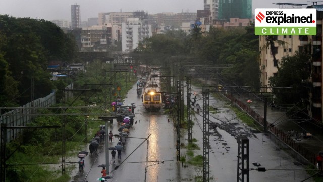
Mumbai heavy rainfall 2025: Torrential rainfall continued to whip Mumbai and its neighbouring districts for the fourth consecutive day on Tuesday (August 19), with several pockets of the city receiving over 300 mm rain in a span of 24 hours.
In less than a week, Mumbai has surpassed the monthly average quota of rainfall for August, which typically stands at 566 mm. For perspective, the rainfall this week is nearly at par with the total that Mumbai received in July, generally the city’s wettest month. While the city’s Santacruz station recorded 798 mm rain in the entire month of July this year, in the past four days, the city has received 791 mm.
The heavy rain has led to one death in a tree-fall incident, while commute across the city has been paralysed.
Across Maharashtra, crops sown over 12-14 lakh hectares have been affected in the past two days due to the rain, Chief Minister Devendra Fadnavis said. In Nanded, eight people have been killed after a cloud burst on Monday.
What has led to the rainfall?
Scientists from India Meteorological Department (IMD) Mumbai attributed the downpour to a combination of several weather systems that bring rain to the city.
A monsoon trough is an elongated low-pressure area that extends from the heat low over Pakistan to the Bay of Bengal. It is a semi-permanent feature of monsoon circulation, and its southward movement results in heavy rain.
According to IMD meteorologists, the monsoon trough is running through Diu, Surat, Nandurbar, and Amaravati. Then there is a depression over south coastal Odisha, which is likely to move further northwards and weaken into a well marked low pressure area. Also, an upper air cyclonic circulation has developed over the north-east Arabian Sea and adjoining Gujarat.
Apart from this, a shear zone — a narrow zone where there is a sharp change in wind speed or direction, leading to cloud formation and rain — is active over the Indian region. An off-shore trough is also stretching through the south Gujarat and North Kerala coast as of Tuesday afternoon.
“Together, these systems have ushered in monsoon currents and will continue to pull in moisture. Rain will only subside after the depression weakens,” said a scientist from IMD Mumbai.
At Mithi river, water level nearly breached the danger mark on Tuesday morning and rose to 3.90 m. The nearby Kranti Nagar area was inundated, with knee-deep levels of rainwater and overflow from the river. The BMC evacuated over 350 people from the slums and shifted them to the nearby civic-run Magandas Nathuram School. The NDRF helped in the operations.
 An NDRF team at Kurla’s Kranti Nagar on Tuesday. (Photo: Amit Chakravarty)
Train services along the harbour line as well as the central railway line between CSMT and Thane were suspended until further notice on Tuesday morning. “Due to high rise of water level in Mithi river, track water logging level is not being discharged. All efforts being taken to reduce water logging from stations / tracks and restore the services as early as possible,” said a spokesperson from the Central Railways on Tuesday afternoon.
The BMC has declared a holiday for all schools and colleges, and government, semi-government and civic offices, barring essential services.
Data from the IMD show that in the past 24 hours between Monday and Tuesday morning, its Santacruz station logged 223 mm of rainfall while Colaba station received 110 mm. However, records from the BMC’s automatic weather stations showed that several pockets received over 300 mm of rain during the same period.
In the past 24 hours, Chincholi in the western suburbs received over 369 mm of rainfall, followed by 337 mm in Kandivali and 305 mm in Dindoshi. Dadar in the island city received 300 mm of rainfall. Coming close to the 300-mm mark, Chembur received 297 mm of rainfall while Vikhroli station recorded 293 mm, and Powai, 290 mm, during the same period.
Records show that this is Mumbai’s rainiest August in the past five years, when the city’s Santacruz station in 2020 received 1,240 mm rain in the month of August.
According to the IMD, the intensity will recede only after the depression in the eastern region subdues. While a red alert — which has remained in place over the past 2 days — will end by Wednesday morning, heavy to very heavy rainfall is here to stay until at least Friday.
For Thursday, the IMD has placed Mumbai, Thane and Palghar districts on orange alert and the Raigad district under red alert. A yellow alert has been sounded for Friday in the Konkan region districts.