Journalism of Courage
Premium
This is an archive article published on October 24, 2022
Depression Over Bay Of Bengal: Cyclonic storm to hit Sunderbans most, rain alert for south districts
The weather department also predicted heavy to very heavy rainfall in the coastal districts of West Bengal – South 24 Parganas and North 24 Parganas – and heavy rainfall in East and West Midnapore on Monday.

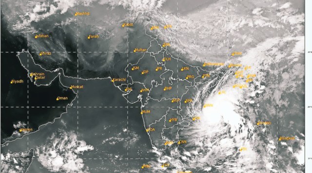 A satellite image of the cyclonic storm over Bay of Bengal on Sunday 6 pm. (Source: IMD)
The cyclonic storm developing over the Bay of Bengal will primarily impact the Sunderbans spread over West Bengal and Bangladesh, as tidal waves are likely to reach a height of six metres owing to the twin effect of the weather system and astronomical tide, the Met Department said on Sunday.
The weather department also predicted heavy to very heavy rainfall in the coastal districts of West Bengal – South 24 Parganas and North 24 Parganas – and heavy rainfall in East and West Midnapore on Monday.
Light to moderate rain will occur in south Bengal districts from Sunday evening till Wednesday morning owing to the system, the IMD said.
Heavy rain will occur in North and South 24 Parganas and Nadia districts on Tuesday, a senior official said.
The deep depression over the central Bay of Bengal is likely to intensify into a cyclonic storm by Sunday evening and after changing course in a northeastward direction from northwest with a speed of 20 kmph in the last few hours, the system will reach north Bay of Bengal before making landfall between Tinkona Island and Sandwip close to Bangladesh’s Barisal in the early morning of Tuesday, a top official said.
The deep depression lay centered over east central Bay of Bengal at 8.30 am Sunday.

Heavy to very heavy rain (07–20 cm) is very likely to occur at one or two places over North 24 Parganas and South 24 Parganas districts on Monday. Heavy rain (07–11 cm) is likely to occur at one or two places over East Midnapore and adjoining West Midnapore districts. Moderate rainfall is likely to occur at one or two places over Kolkata, Howrah and Hooghly districts of South Bengal.
Story continues below this ad
The Weather department has issued heavy rain (07–11 cm) at one or two places over North and South 24 Parganas and Nadia districts on Tuesday.
Moderate rainfall is likely to occur at one or two places over Murshidabad district of South Bengal, the IMD said. “The main affected area will be the Sunderbans in the coastal areas of North and South 24 Parganas districts of West Bengal and in Bangladesh,” Deputy Director General of Regional Met Centre, Sanjib Bandopadhyay, said.
The development comes as people gear up to celebrate Kali Puja and Diwali.
The cyclone is expected to be named ‘Sitrang’, as suggested by Thailand.
Story continues below this ad
He said that heavy rain, accompanied with winds gusting up to 100 kmph and high tidal waves are likely to cause damage to ‘kutcha’ (mud) embankments, roads and houses, disruption of power and communication lines.
Bandopadhay said the major concern is breakage of kutcha embankments, owing to storm surge accompanied with high astronomical tide on new moon, which may lead to sea water inundation of low-lying areas in these places. “The height of the waves due to the cyclone will be one metre above astronomical tide level, but since new moon is on October 25, the tide level owing to it will be five to six metres at West Bengal and Bangladesh coasts, so effective height of the tide at the time of landfall on the morning of that day will be around six metres in North and South 24 Parganas,” he said.
The tide level is likely to be higher at Bangladesh coast, as the height of waves due to the cyclone will be around two metres, he said.
The system is likely to bring in its wake winds reaching speeds of 80-90 kmph gusting to 100 kmph in coastal North 24 Parganas and South 24 Parganas on Tuesday, while speeds of 45-55 kmph gusting to 65 kmph could be experienced on Monday in these districts along with East Midnapore, the IMD said in a bulletin.
Story continues below this ad
Kolkata, Howrah, Hooghly and West Midnapore are likely to be affected by winds reaching speeds of 40-50 kmph gusting to 60 kmph on Tuesday, and 30-40 kmph gusting to 50 kmph on Monday, it said.

A Kolkata Municipal Corporation official said it has initiated steps to tackle any situation that may emerge owing to the impending cyclone in the metropolis, including keeping all pumping stations active and making arrangements for shifting residents from dilapidated buildings to local schools or community halls.
The weather office also said wind speed over sea areas will reach 90-100 kmph gusting to 110 kmph in north Bay of Bengal, asking fishermen not to venture into the sea. It advised suspension of ferry services in Sunderbans and waterbound tourist activities at seaside resort towns of Digha, Mandarmoni, Shankarpur, Bakkhali and Sagar on Monday and Tuesday.
Meanwhile, the Odisha government said it has prepared for possible heavy rain on Monday and Tuesday, when the cyclone passes parallel to the state’s coast. The IMD has issued a ‘yellow’ warning for heavy rainfall (7-11cm) at one or two places over Kendrapada, Jagatsinghpur and Puri districts till Monday morning. It also warned of heavy rainfall at one or two places over Balasore, Bhadrak, Jajpur, Kendrapada, Jagatsinghpur, and Cuttack.
Advertisement
Top Stories


Live Blog
Loading Taboola...
Advertisement