Stay updated with the latest - Click here to follow us on Instagram
Premium
This is an archive article published on August 30, 2022
Heavy rain wreaks havoc in Bengaluru as streets, residential layouts get flooded
With 364.2 mm of rainfall in August so far, the city is short of breaking an all-time record of 387.1 mm in August 1998, data from the IMD shows.
By: Express News Service
Bengaluru | Updated: August 31, 2022 07:06 AM IST
 Residents use a boat to travel at the flooded Rainbow Drive locality in Bengaluru on Tuesday, Aug. 30. (PTI)
Several residential areas in Bengaluru were waterlogged and inundated Tuesday after heavy rain lashed the Karnataka capital a day before, prompting authorities to send rafts to evacuate people.
Officials said commuters faced a harrowing time navigating the path on the Bellandur Outer Ring Road (ORR) because of water logging in the area.
According to the weather department, Bengaluru received 12.8 mm of rainfall on Monday. Bengaluru has recorded 364.2 mm of rainfall in August so far, data from the India Meteorological Department (IMD) shows. The city is short of breaking an all-time record of 387.1 mm in August 1998.
Bengaluru has since March this year received 1,091 mm of rainfall with the wettest months of September and October still ahead. The spell of heavy rain slows down by mid-November.
The authorities sent rafts to evacuate the stranded residents of Rainbow Drive Layout in Sarjapur.
The residents said the water level inside the residential layout reached six feet making it difficult for a tractor to move inside for evacuation.
Authorities sent rafts to evacuate the stranded residents of Rainbow Drive Layout in Sarjapur on Monday and Tuesday.#bengalururains
Watch the video here: pic.twitter.com/H21tOfdmmx
— Express Bengaluru (@IEBengaluru) August 30, 2022
“The water is stagnant at the entrance of the layout. In some of the houses, refrigerators are floating. The ground floor of most of the houses are submerged,” said Purush Malathi, a resident of Rainbow Drive Layout.
“Though we face the issue of inundation in every shower, this time the situation worsened due to the Halayanakanahalli lake breach which happened for the first time. The officials from the BBMP (Bruhat Bengaluru Mahanagara Palike) have arrived,” added Malathi.
Story continues below this ad
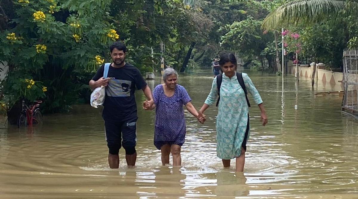 Residents wade through a waterlogged road on Tuesday at Rainbow Drive Layout on Sarjapura Road, which is under 7 feet water with more than 30 homes being under 2-3 feet of water. (Express Photo)
Aravind Limbavali, the MLA of Mahadevapura Constituency, announced in May that the major roads department of the civic body BBMP would in the public-private model construct a drain, which will carry rainwater from the layout to the culvert in Sarjapur.
Malathi said the work has begun and is undergoing at a fast pace.
One of the major complaints highlighted by the residents of Rainbow Drive Layout, which has more than 350 houses, is that rainwater from the surrounding villages of Junnasandra and Halanayakanahalli is diverted into their area, leading to massive inundation.
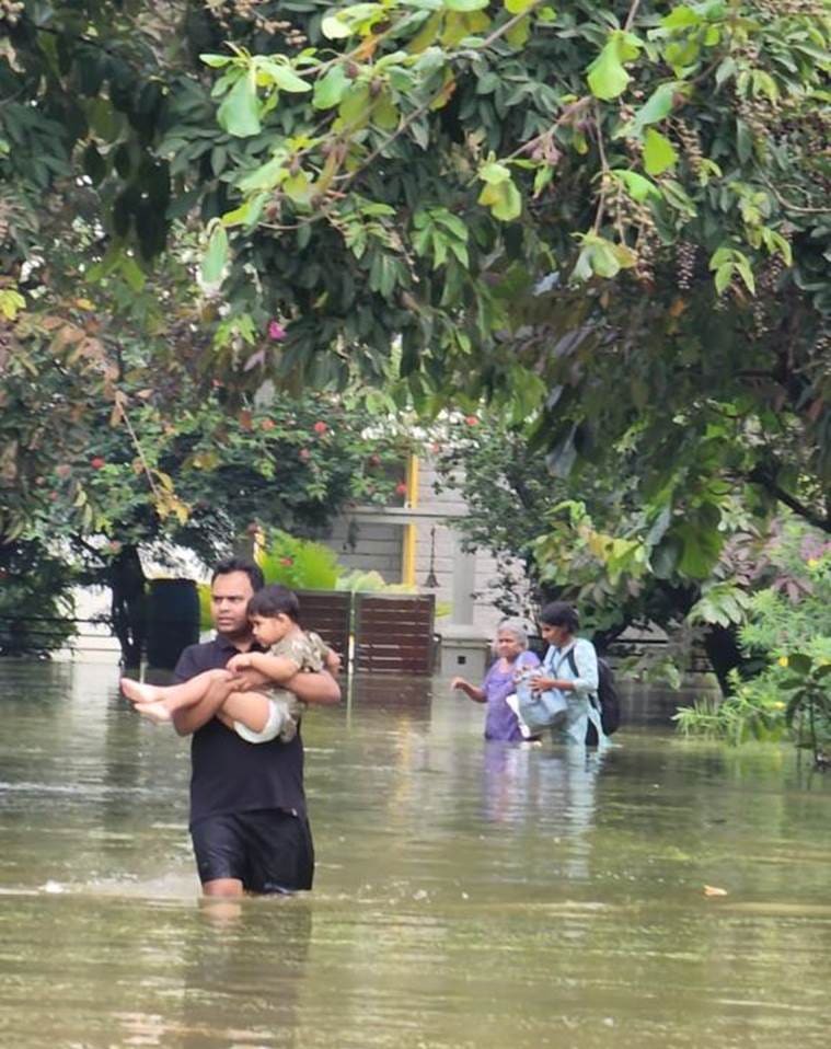 A man carries his child as he wades through the water Rainbow Drive Layout on Sarjapura Road on Tuesday. (Express Photo)
The residents also complained of water gushing into another residential layout, Sunny Brooks Layout, and the Wipro campus in Sarjapur after a nearby drain overflowed.
Story continues below this ad
On Monday evening, Chief Secretary Vandita Sharma said during a meeting with government officials that the drains should be desilted to ensure the smooth flow of rainwater.
According to the data shared by Karnataka State Natural Disaster Monitoring Centre (KSNDMC), 96 people have lost their lives due to rain in different parts of the state since June 1. A 56-year-old man and a 60-year-old woman were killed in Ramanagara as the district witnessed severe rainfall.
“Since June 1, owing to the southwest monsoon, 993 houses have been completely damaged, 10,274 severally damaged and 16,119 partially damaged in different parts of the state. 187 villages have been affected due to rain,” the KSNDMC said.
Bengaluru’s topography is characterized by a series of well-defined valleys — Vrishabhavathi valley, Koramangala valley, Challaghatta valley and Hebbal valley. The lakes were built across these valleys and floodwater used to flow through these valleys.
Story continues below this ad
According to the scientists and ecologists, the natural canals along the valleys have been blocked with rampant urbanisation of the city.
Senior program manager (geo-analytics) at the World Resources Institute (WRI) India, Raj Bhagat, explaining the reason behind the flooding of Bengaluru-Mysuru highway said it is imperative to understand the importance of valleys if flooding has to be reduced.
“Near wonderla (amusement park) exit in Bengaluru – Mysuru road, there existed a valley system. The construction spree on top of the valley system started when the road was expanded along with a toll gate right on top of the valley! And other built-up came along the highway to completely cause the valley system to be obstructed. After heavy rain, the water couldn’t move anywhere as there were no drainage alternatives. So it began stagnating and moving on top of the roads!” he tweeted.
The city has an 840 km length of drainage network.
Ram Prasad, the co-founder of citizens’ volunteer group Friends of Lakes, said that lakes should be treated as flood mitigation centres.
Story continues below this ad
“Water cannot escape since they have been encroached. Lakes should be treated as flood mitigation centres and rain water harvesting points,” said Prasad.
“Urban planning has been the worst in the peripheral areas of Bengaluru. The construction of buildings on valleys and lake beds have resulted in the mess we are around today. All encroachments from the lakes and drains should be removed,” he added.
Captain (Retd.) Santhosh Kumar, who is working with the government agencies to remove encroachments from the storm water drains connecting lakes in Anekal, said: “We have found the reason for flooding in Anekal. The storm water drains are encroached and I am working with the government agencies to remove the encroachments.”
“The drains should be desilted as well and their connectivity with the lakes should be re-established,” he added.
Story continues below this ad
Dr TV Ramachandra, a faculty at the Indian Institute of Science (IISc), has pointed out that the wetland of Agara-Bellandur lakes which earlier aided in retaining rainwater and aided in groundwater recharge has been abused with the construction activities in the SEZ by the Karnataka Industrial Areas Development Board (KIADB).
“The storm water drain connecting Bellandur lake from city market was narrowed to 28.5 meters against the original width of 60 meters thereby violating NGT (National Green Tribunal) guidelines of maintaining the physical integrity of storm water drains and buffer zone,” said Dr Ramachandra.
“The SEZ in Bellandur-Agara wetlands should be shifted to other regions in Karnataka and further industrialization and construction of commercial establishments in the region should be stopped,” he added.
The IMD has predicted widespread rain over Bengaluru for the next five days.
Story continues below this ad
Ramanagara, which was badly affected due to rain on Monday, received 32.5 mm of rainfall. The highest rainfall of 193 mm in Karnataka was recorded in Gubbi of Tumkuru district.
“We are still clearing the silt from drains and there are legal hurdles in removing the encroachment from drains,” said a senior BBMP official on the condition of anonymity.
“Lakes are also overflowing and this is the major reason behind the inundation of roads and residential layouts. Moreover, the government grants in the restoration of lakes is minimal to address the issues of flooding,” he added.
Major areas in Bengaluru affected by rain: Sarjapur, Bellandur, Koramanagala, Bommanahalli, KR Market, RR Nagar
Reasons for flooding: Construction on drains and lakes
Advertisement
You May Like


Live Blog
Top Stories


Advertisement