Stay updated with the latest - Click here to follow us on Instagram
Journalism of Courage

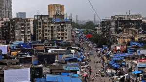
 The BMC has formulated a rescue plan for the entire city using the findings of the report. Express Archive
A study carried out by IIT Bombay on the city’s vulnerability in case of an earthquake shows that there is an active faultline in Panvel and the risk of collateral damage is highest for people living in the areas near Govandi and Mankhurd. The Brihanmumbai Municipal Corporation, which had sanctioned funds for the study, has formulated a rescue plan for the entire city using the findings of the report and the disaster management department is in the process of fine-tuning the plan.
Civic officials said that at the time when the BMC was designing the comprehensive disaster management plan, IIT Bombay had informed them about the active faultline. “After we came to know about the faultline, which begins at Koparkhairne and ends in Bhiwandi, we asked IIT Bombay to carry out a detailed ward-wise study to understand the risk-prone areas of the city so that we can plan accordingly. With the help of a formula using the peak ground acceleration and peak ground velocity, we have calculated the hypothetical impact if an earthquake of a magnitude of 6.5 on the Richter scale hits the city and have charted out the rescue plan accordingly,” said a BMC official.
Municipal commissioner Ajoy Mehta said, “Our aim is to improve the response during a disaster and we are in the process of modernising the disaster management plan. With respect to this scenario, however, citizens should get the structural audit of their buildings done on a regular basis.”
An official from the disaster management department said that Mumbai is only around 18 km away from Panvel, the site of the fault line, and the impact of an earthquake would be highest on the eastern suburbs. “The report indicates that based on the proximity from the epicentre, the most vulnerable wards include M East ward (Mankhurd and Govandi), S ward (Vikhroli), T ward (Mulund) and N ward (Ghatkopar). While south Mumbai is the least vulnerable, western suburbs are also far from the epicentre and not as much at risk,” said the official.
A fault line is a break or fracture in the ground that occurs when the Earth’s tectonic plates move or shift and are likely sites for earthquakes to occur. According to the study called Hazard Vulnerability Risk Assessment on Seismic Microzonation which has been carried out for the first time, apart from mapping the risk-prone areas, the study has calculated the number of deaths, injured and economic losses in terms of property and infrastructure.
The report was submitted to the BMC in 2012 after which the disaster management department has been working on the rescue plan for the past one year. “We divided the city into a grid of 7700 parts and each was spread out over an area of 250 square metre. We then superimposed the grid map onto our existing base map and created a separate evacuation plan for every section of the grid. In the plan, we have mapped the schools, hospitals in the area as well as open spaces where rescue shelters can be constructed and people can be shifted,” said the official.
The study was carried out over a period of two years by a team of professors and students from IIT Bombay led by Ravi Sinha, a professor in the civil engineering department who specialises in structural engineering and disaster management planning. Sinha said that according to the national catalogue of earthquakes, the last known big earthquake in the city is listed in 1618 which had led to the death of 20000 people when the total population of Mumbai was around 2 lakh people. “There are fractions of movement of the tectonic plates every year in active fault lines and there are ways of measuring them,” he said.
Sinha said that from the safety point of view, it is important to understand the consequences of a natural calamity. He added that the report has also made certain recommendations that citizens can take up to reduce chaos likely to happen in case of such a disaster. “There are simple solutions that all citizens can adopt including better coordination with their family members in case there is a breakdown of transportation. They should know more about the area they live in and understand the likely impact of an earthquake on their grid and know all the open spaces nearby. They can plan meeting points with other family members who live in another area in the city,” said Sinha.
In order to provide further details of the rescue plan, the disaster management department has told the BMC’s assessment and collection department to carry out a detailed survey of 25000 properties in the city for a microscopic understanding of the city. “Since we are already using LiDar technology to map the city, the department will also take into account the attributes of 25,000 structures. The survey will be conducted over a period of three months,” said the official. The long list of properties include fire stations, police stations, hospitals, sea front properties, slum areas, de-watering pumping stations, government offices, and chemical gas storage among others,” said the official.
Stay updated with the latest - Click here to follow us on Instagram