What is the issue?
Cyclone Montha, which crossed the Andhra Pradesh coast past midnight on Tuesday (October 28), left three persons dead, damaged standing crops over 1.50 lakh acres and disrupted power and transportation. Earlier this month, Cyclone Shakti developed off the Gujarat coast in the Arabian Sea, but it moved away from the Indian coast. Cyclones are reported in the news each year, making it essential to understand this significant geographical phenomenon from a broader perspective.
(Relevance: UPSC Syllabus General Studies-I, III: Important Geophysical phenomena such as earthquakes, Tsunami, Volcanic activity, cyclones etc., disaster management.)
Question 1: What is a cyclone? How is it formed and what happens during its landfall?
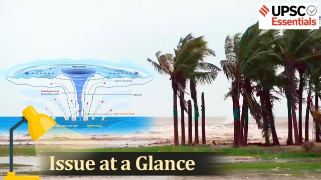
A cyclone is a large-scale system of air that rotates around the centre of a low-pressure area. It is usually accompanied by violent storms and bad weather. As per National Disaster Management Authority (NDMA), a cyclone is characterised by inward spiralling winds that rotate anticlockwise in the Northern Hemisphere and clockwise in the Southern Hemisphere. The NDMA classifies cyclones broadly into two categories: extratropical cyclones and tropical cyclones.
Tropical cyclones
Tropical cyclones are those which develop in the regions between the Tropics of Capricorn and Cancer. They are the most devastating storms on Earth. Such cyclones develop when “thunderstorm activity starts building close to the centre of circulation, and the strongest winds and rain are no longer in a band far from the centre,” NOAA noted.
The core of the storm turns warm, and the cyclone gets most of its energy from the “latent heat” released when water vapour that has evaporated from warm ocean waters condenses into liquid water, the agency added. Moreover, warm fronts or cold fronts aren’t associated with tropical cyclones.
Story continues below this ad
Tropical cyclones have different names depending on their location and strength. For instance, they are known as hurricanes in the Caribbean Sea, the Gulf of Mexico, the North Atlantic Ocean and the eastern and central North Pacific Ocean. In the western North Pacific, they are called typhoons.
Extratropical cyclones
Also known as mid-latitude cyclones, extratropical cyclones occur outside of the tropic. They have “cold air at their core, and derive their energy from the release of potential energy when cold and warm air masses interact”, according to the US National Oceanic and Atmospheric Administration (NOAA).
Such cyclones always have one or more fronts — a weather system that is the boundary between two different types of air masses. One is represented by warm air and the other by cold air — connected to them, and can occur over land or ocean.
‘Landfall’ of a cyclone
Simply put, landfall is the event of a tropical cyclone coming onto land after being over water. As per the India Meteorological Department (IMD), a tropical cyclone is said to have made landfall when the centre of the storm – or its eye – moves over the coast.
Story continues below this ad
Crucially, a landfall should not be confused with a ‘direct hit’, which refers to a situation where the core of high winds (or eyewall) comes ashore but the centre of the storm may remain offshore. As per the US NOAA, because the strongest winds in a tropical cyclone are not located precisely at the centre, it is possible for a cyclone’s strongest winds to be experienced over land even if landfall does not occur.
The damage caused by the landfall depends on the severity of the cyclone, marked by the speed of its winds. If the cyclonic storm is “very severe”, the impact may include extensive damage to kutcha houses, partial disruption of power and communication lines, minor disruption of rail and road traffic, potential threat from flying debris and flooding of escape routes. The factors behind this kind of damage include extremely strong winds, heavy rainfall and storm surges, which cause devastating floods on the coast.
Landfalls can last for a few hours, with their exact duration depending on the speed of the winds and the size of the storm system. Notably, cyclones lose their intensity once they move over land because of a sharp reduction in moisture supply and an increase in surface friction. This means that while landfalls are often the most devastating moments of cyclones, they also mark the beginning of their end.
Question 2: How are cyclones named and what is the significance of this naming system?
In 2000, a group of nations called WMO/ESCAP (World Meteorological Organisation/United Nations Economic and Social Commission for Asia and the Pacific), which comprised Bangladesh, India, the Maldives, Myanmar, Oman, Pakistan, Sri Lanka and Thailand, decided to start naming cyclones in the region on a rotational basis. After each country sent in suggestions, the WMO/ESCAP Panel on Tropical Cyclones (PTC) finalised the list.
Story continues below this ad
The WMO/ESCAP expanded to include five more countries in 2018 — Iran, Qatar, Saudi Arabia, United Arab Emirates and Yemen. The list of 169 cyclone names released by IMD in April 2020 were provided by these countries — 13 suggestions from each of the 13 countries.
Worldwide, there are six regional specialised meteorological centres (RSMCs) and five regional Tropical Cyclone Warning Centres (TCWCs) mandated for issuing advisories and naming of tropical cyclones. IMD is one of the six RSMCs to provide tropical cyclone and storm surge advisories to 13 member countries under the WMO/ESCAP Panel. RSMC, New Delhi is also mandated to name the Tropical Cyclones developing over the north Indian Ocean (NIO), including the Bay of Bengal (BoB) and the Arabian Sea (AS). So, the tropical cyclones forming over different Ocean basins are named by the concerned RSMCs & TCWCs.
There are some conventions too, some rules are to be followed while naming cyclones, such as:
📍The proposed name should be neutral to (a) politics and political figures (b) religious believes, (c) cultures and (d) gender.
Story continues below this ad
📍Name should be chosen in such a way that it does not hurt the sentiments of any group of population over the globe.
📍It should not be very rude and cruel in nature.
📍It should be short, easy to pronounce and should not be offensive to any member.
📍The maximum length of the name will be eight letters.
Story continues below this ad
Apart from helping the general public, naming cyclones helps the scientific community, the media, disaster managers etc. With a name, it is easy to identify individual cyclones, create awareness of its development, rapidly disseminate warnings to increase community preparedness.
Question 3: What makes the Bay of Bengal so prone to frequent cyclones?
The Bay of Bengal, the world’s largest bay, covering an area of 2,600,000 sq km, is one of the most cyclone-prone regions on Earth. According to research published by Dr Jeff Masters, hurricane scientist and meteorologist who documents extreme weather, in the Yale Climate Connections platform, 22 of the 30 deadliest tropical cyclones in world history have been recorded in the Bay of Bengal and during the past two centuries.
A research paper published in 2009 noted that more tropical cyclones are formed in the Bay of Bengal than in the Arabian Sea, and the frequency of storm surges is also greater. The Bay of Bengal is prone to large storm surges, in part because of its funnel-like shape and topography where it is shallow for a large distance from the coast. This unique geographical shape has contributed to the region witnessing some of the deadliest disasters in world history.
The northern part of the Bay of Bengal is very shallow, where the coast is landlocked on three sides. When a very severe cyclonic storm approaches the coast, the enormous storm surge generated by the wind pressure submerges the coastal belt when the storm passes through the region.
Story continues below this ad
Another unique feature of this coast along the West Bengal-Bangladesh belt is that it is crisscrossed by several rivers and rivulets, where the elevation of the islands is 4 to 5 metres above sea level. The sea-dykes and embankments are not strong enough to resist strong wind-driven waves and cave in during a depression or a cyclonic storm. The frequency of storms crossing this belt is also high, all of which contributes to the severity of the impact of the cyclones that impact this region.
An academic paper titled ‘Effect of landfall location and coastal topography on surge response in the Northern Bay of Bengal’, published in 2020, mentions that the destruction caused by storm surges also depends on the shape of the coastline. “A storm surge is highly dependent on local features and barriers that affect the flow of water. The Bay of Bengal has a complex coastal geometry, including estuary deltas, pocket-like bays, and straight coasts.”
Another important factor is temperature. Warmer the water, more intense the cyclone, and the Bay of Bengal has generally recorded higher temperatures than the Arabian Sea. Although, due to climate change-related disruptions of late, the western coast of India is also witnessing more frequent and stronger cyclones.
Historically, the Bay of Bengal has been known for tropical cyclones. But over the years there has been an increase in cyclones forming in the Arabian Sea, as well. An analysis of past data of cyclones over the North Indian Ocean from 1891–2020 indicates that the frequency of extremely severe cyclonic storms has increased in recent years over the Arabian Sea since 1990.
Story continues below this ad
Question 4: How is climate change influencing the frequency and intensity of cyclones?
There is no dearth of reports highlighting the consequences of climate change, including droughts, water scarcity, severe wildfires, rising sea levels, etc. The impact of climate change on the frequency and intensity of cyclones is also evident.
The average global temperature on Earth has increased by at least 1.1 degree Celsius since 1850, primarily due to human activities that have released unprecedented levels of greenhouse gases into the atmosphere. The spike in the temperatures has resulted in more frequent and more intense cyclones.
There is a growing body of evidence that soaring temperatures are also making cyclones stronger and more frequent. A 2023 study suggested that major hurricane landfalls in the eastern Pacific could become up to 30% more frequent in case global temperatures soar by at least 2 degree Celsius. The rising surface temperatures of the oceans are the main reason behind such hurricanes.
The oceans have absorbed 90% of the additional heat generated by the greenhouse gas emissions in recent years. Due to this, global mean sea surface temperature has gone up by close to 0.9 degree Celsius since 1850 and around 0.6 degree Celsius over the last four decades. Higher sea surface temperatures cause marine heat waves, an extreme weather event, which, in turn, makes storms like hurricanes and tropical cyclones more intense.
Post Read Questions
Prelims
(1) Consider the following statements: (UPSC CSE 2020)
1. Jet streams occur in the Northern Hemisphere only.
2. Only some cyclones develop an eye.
3. The temperature inside the eye of a cyclone is nearly 10ºC lesser than that of the surroundings.
Which of the statements given above is/are correct?
(a) 1 only
(b) 2 and 3 only
(c) 2 only
(d) 1 and 3 only
(2) The 2004 Tsunami made people realise that mangroves can serve as a reliable safety hedge against coastal calamities. How do mangroves function as a safety hedge? (UPSC CSE 2011)
(a) The mangrove swamps separate the human settlements from the sea by a wide zone in which people neither live nor venture out
(b) The mangroves provide both food and medicines which people are in need of after any natural disaster
(c) The mangrove trees are tall with dense canopies and serve as an excellent shelter during a cyclone or tsunami
(d) The mangrove trees do not get uprooted by storms and tides because of their extensive roots
Mains
1. What is sea surface temperature rise? How does it affect the formation of tropical cyclones? (UPSC CSE 2024)
2. Tropical cyclones are largely confined to the South China Sea, Bay of Bengal and Gulf of Mexico. Why? (UPSC CSE 2014)
3. The recent cyclone on the east coast of India was called “Phailin”. How are the tropical cyclones named across the world? Elaborate. (UPSC CSE 2013)
| Prelims Answer Key |
| 1. (c) 2. (d) |
(Sources: Cyclone Fengal makes landfall over Puducherry, How are cyclones named?, Cyclone Montha landfall: What exactly is a ‘landfall’, how much damage can it cause?, What makes the Bay of Bengal so prone to frequent cyclones, Cyclone Montha likely to hit east coast, How does climate change impact extreme weather events?)
Subscribe to our UPSC newsletter. Stay updated with the latest UPSC articles by joining our Telegram channel – Indian Express UPSC Hub, and follow us on Instagram and X.
🚨 Click Here to read the UPSC Essentials magazine for October 2025. Share your views and suggestions in the comment box or at manas.srivastava@indianexpress.com🚨