© IE Online Media Services Pvt Ltd

 The Indus (Source: Wikimedia Commons)
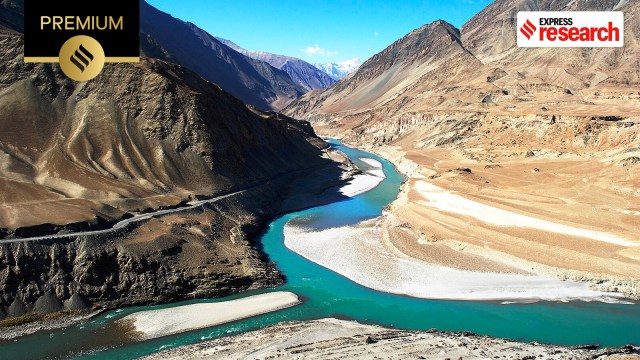
On April 22, a terrorist attack in Pahalgam, Kashmir, left 26 civilians dead. The shock rippled through New Delhi. In response, the Indian government announced a series of diplomatic measures, including the suspension of the Indus Waters Treaty (IWT), a landmark yet fragile agreement between two nuclear-armed nations.
This isn’t the first time the IWT, signed in 1960 under the auspices of the World Bank, has been drawn into political turmoil. The 2008 Mumbai terror attacks, the 2016 Uri terror attack, and the 2019 Pulwama terror attack all reignited debate around the treaty, with India using it as a strategic lever, a calculated warning shot across the border. Despite these tensions, the treaty has endured for 65 years, weathering wars and diplomatic standoffs.
Why does a river lie at the heart of one of the world’s most dangerous rivalries? To understand that, we must go beyond the border drawn in 1947 and dive into the deeper, tangled roots of history.
The Indus River Basin spans four countries: Pakistan, India, China, and Afghanistan. As Sadiq Khan, associate scientist, University Corporation for Atmospheric Research, US, and Thomas Adams III, an expert in hydrology, note in Indus River Basin: Water Security and Sustainability, Pakistan holds the largest share of the basin at 61%, followed by India with 29%, and China and Afghanistan with 8%.
Geologically, the Indus is among Asia’s oldest rivers. It likely began forming during the early Eocene Epoch, shaped by the tectonic uplift of the Tibetan Plateau following the collision of the Indian and Asian continental plates. This set the stage for one of humanity’s earliest and most advanced civilisations: the Indus Valley Civilisation (c. 3000-1500 BCE).
At its height, the Indus Valley Civilisation, contemporary with Mesopotamia, Egypt, and China’s Yellow River basin, was the largest of the ancient urban cultures, spanning over 1,500 kilometres.
 A water reservoir at Dholavira, a site of the Indus Valley Civilisation (Source: Wikpedia)
Over the next two millennia, the Indus region became a crossroads for conquest, culture, and exchange. In 326 BCE, Alexander the Great crossed the river, and after his departure, Chandragupta Maurya unified the region under the Mauryan Empire. In the early 8th century, Muhammad bin Qasim’s invasion brought significant political and religious shifts to the area.
Further upriver, in Kashmir, the 9th-century Hindu king Avantivarman (855–883 CE) utilised the Indus and its tributaries to stabilise and grow his kingdom. Centuries later, Mohammad bin Tughlaq introduced water harvesting and double cropping to further boost agricultural output.
Uttam Kumar Sinha, Senior Fellow at the Manohar Parrikar Institute for Defence Studies and Analyses, points out that in Vedic times, the Indus Basin was known as the Sapt Sindhu, or “land of seven rivers,” which included the Saraswati. The Rigveda’s Book 6 describes the Saraswati as “surpassing in majesty and might of all other rivers.” By Book 10, Sinha notes, the Indus had emerged as the dominant river. “During this period, the rivers of the Indus region were referred to by various names: the Indus as Sindhu, the Chenab as Asikni, the Jhelum as Vitasta, the Ravi as Purushni, the Sutlej as Shutudri, and the Beas as Vipas,” he tells indianexpress.com.
Since the late 19th century, the Indus River Basin has undergone one of the most dramatic irrigation transformations in modern history, beginning under British colonial rule. “The Mughals enhanced irrigation knowledge, while the British expanded canal systems in the 19th century, viewing control over the trans-Indus region as key to imperial power, economic gain, and strategic security,” says Sinha.
The British built extensive canal networks and established colonies in Punjab to boost agriculture. British engineers harnessed the river’s power, culminating in the 1915 Triple Canal Project, which connected major tributaries through link canals.
“But it wasn’t just about expanding agriculture,” says Sinha. “The British also introduced a series of barrages and dams to control the river’s flow.” These structures not only reduced flooding and ensured reliable irrigation but also altered the river’s natural course, forever reshaping its relationship with the land.
After Independence in 1947, India and Pakistan inherited this vast, interlinked irrigation system. Both nations relied heavily on the Indus to support their agriculture-based economies, but Partition left no formal framework for managing the river’s waters. This lack of agreement led to disputes over access and control. As tensions escalated, the World Bank stepped in to mediate in 1951, ultimately proposing a territorial compromise: India would control the eastern tributaries (Ravi, Beas, and Sutlej), while Pakistan would retain control of the Indus mainstem and the western tributaries (Indus, Jhelum, and Chenab).
Historian David Gilmartin notes, “Intensification of water use in fact lay at the heart of the treaty’s logic.” To implement this vision, India built the Bhakra Dam in 1963, while Pakistan, with support from the World Bank and other international donors, launched the expansive Indus Basin Project, anchored by the Tarbela Dam, completed in 1977.
 Jawaharlal Nehru during the construction of the Bhakra Dam in Punjab, 1953 (Source: Wikipedia)
However, Dr Nilanjan Ghosh, Vice President of Development Studies at the Observer Research Foundation (ORF), argues that the treaty was not equitable for two key reasons. First, the Western rivers carried about 99-100 billion cubic meters of water, while the Eastern rivers had only 39-40 billion cubic meters. Second, the treaty did not account for emerging environmental challenges, such as climate change, a factor that has become increasingly important in regions like the Himalayas and the Kushu area.
While Ghosh credits India as the upper riparian state, with upholding the IWT, historian and nonresident senior fellow at Carnegie India, Srinath Raghavan, argues that the treaty reflects only “minimal levels of cooperation.” He contends that it divides the six rivers — allocating the western rivers to Pakistan and the eastern rivers to India — effectively sidestepping the need for joint development.
The Indus River Basin, home to nearly 300 million people, is under growing pressure from climate change, population growth, and rising water demand. Gilmartin highlights one of the river’s most striking features: its extreme seasonality, with 50% of its annual flow occurring between July and September when snowmelt combines with monsoon rains.
As 80% of its flow comes from glaciers, the basin is especially vulnerable to climate-induced glacial melt. “In the short term, this means more floods. In the long term, it means less water in summer, just when it’s needed most,” explains Sinha. He notes that Pakistan, where the Indus supports 90% of agriculture, is particularly vulnerable, as water availability has dropped below critical levels, with irrigation losses exceeding 50% in some areas. “Food and water insecurity are deepening.”
Author of An Environmental History of India, Michael H Fisher, adds, “Almost all the water in Pakistan flows from other countries, particularly India and Afghanistan, meaning control is not in Pakistan’s hands. With melting glaciers and irregular monsoons, Pakistan no longer controls the diminishing Indus flow.”
Gilmartin concurs: “India has the upper hand on this issue. It’s not just because India is bigger and stronger, but India can theoretically stop the water whenever it wants. In fact, India had stopped water on April 1, 1948, disrupting major canals flowing into Pakistan’s Punjab.”
However, Ghosh points out that the issues at hand go beyond upstream diversions. “Agricultural water use in Pakistan in their boundary leaves nominal draft for the delta fisheries to thrive. So it’s an agriculture vs. fisheries issue. There is no water management and reprehensible wastage and water withdrawal within Pakistan, drying out the delta,” he argues.
 The Brahmaputra (Source: Wikipedia)
Citing a comparable case, Gilmartin points out that India, like Pakistan, faces similar challenges with its rivers, such as the Brahmaputra. “China, being the upstream riparian in this case, has been constructing dams on the Brahmaputra for a decade, potentially diverting water that could affect the Bengal Delta and Bangladesh.” However, Fisher stresses that while the Brahmaputra flowing from China into northeastern India is crucial for India, the Indus holds far greater significance for Pakistan.
As Raghavan states, “Environmental diplomacy will be an essential part of our engagement with neighbours. Climate change will require coordination between countries. The climate crisis will, in fact, become a far greater concern than terrorism.”
Hope persists, as water has the potential to foster cooperation just as much as it can fuel conflict. Sinha emphasises this point, noting that many shared rivers around the world, such as the Nile, Mekong, and Danube, have prompted nations to pursue negotiation rather than confrontation. “Since 805 AD, more than 3,600 international water treaties have been signed, many forged during times of political tension,” he concludes.
Further reading:
Indus Basin Uninterrupted: A History of Territory & Politics from Alexander to Nehru by Uttam Kumar Sinha
An Environmental History of India: From Earliest Times to the Twenty-First Century by Michael H. Fisher
Blood and Water: The Indus River Basin in Modern History by David Gilmartin
Indus River Basin: Water Security and Sustainability edited by Sadiq I. Khan and Thomas E. Adams III