Journalism of Courage


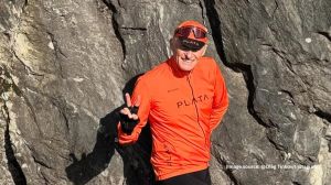
 Manmohan Singh Bawa has spent a lifetime on this trail. A cartographer, Bawa is the only one in India to have devoted his skill solely to charting trekking routes.
8216;8216;It started in the late 1950s when I first discovered the fun of trekking. It was a relatively straightforward trek, travelling from Delhi to Kulu-Manali and then going to the Rohtang Pass. There was not a line of information for anyone those days, and I took notes. If I took a particular road, I would ask locals where the other roads went. So, on one trek, I discovered facts about four-five different treks. Those I covered the next time,8217;8217; says Bawa, now settled in Dalhousie in Himachal Pradesh.
The obsession with trekking grew when Bawa became part of the Youth Hostel Association of India and started writing on his treks and expeditions in the association8217;s journal. 8216;8216;Sometimes, I provided maps with my articles,8217;8217; Bawa explains. 8216;8216;Then climbers approached me for maps. Gradually, through the contacts I made, I drew out maps for some of the Himalayan tourism organisers. This was around the late 1970s and early 1980s.8217;8217;
He hasn8217;t looked back since. He gave up his job as a commercial artist with the American Center in New Delhi to move full-time into cartography. 8216;8216;I have since drawn ten maps of the Himalayas, which have been published by a London firm. These are the definitive maps of the entire Himalayan range.8217;8217;
Bawa shows his maps; the 3ft/2ft sheets have the mountains marked in thick red lines, with dotted lines marking the trekking routes. 8216;8216;The most important thing is the altitude. I have also marked out camping grounds, tents, rest houses and cave shelters. That8217;s to help you plan your route according to your budget.8217;8217;
You would ordinarily think that charting trekking routes across the most complicated mountain range in the world is not possible in one lifetime. 8216;8216;Of course it8217;s not,8217;8217; says Bawa. But then he adds, 8216;8216;It is too, because you don8217;t have to go on every trek to be able to chart it. When you go on a trek, you find out about other treks. You ask questions, ask for details. My greatest achievement is in the altitudes I have marked. They are 99 per cent correct. Not 100, because the heights of mountains change constantly. So I update the maps every ten years.8217;8217;
His biggest clientele are the European backpackers, who he says buy his maps from select outlets in London. At present, Bawa is plotting his next big trip8212;to Kailash via Lhasa in Tibet. But he is saddened by the declining interest in trekking. 8216;8216;I only wish more people would hit the trail more often. It8217;s the greatest trip in the world.8217;8217;