Stay updated with the latest - Click here to follow us on Instagram
Journalism of Courage

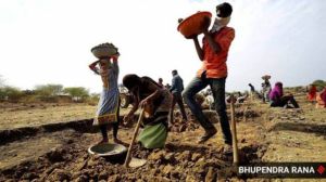
2014: The year of tragedy
[Jammu and Kashmir | Picking up the Pieces ]
SEPTEMBER 13, 2014
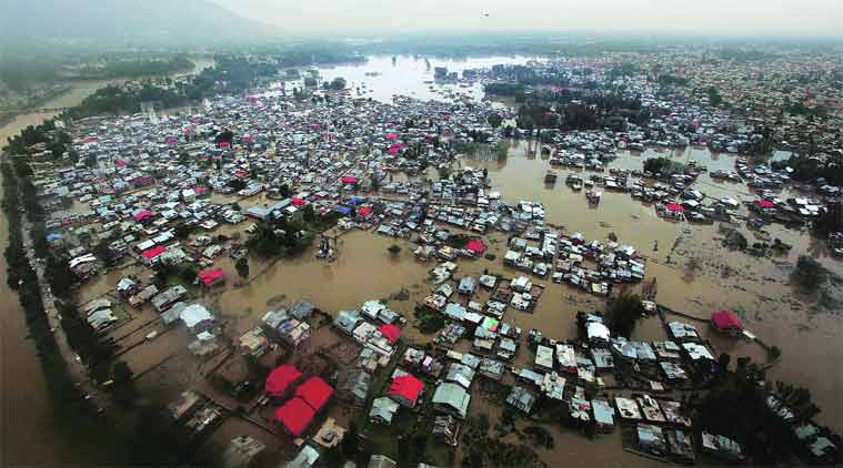
Close to 300 people died in a deluge of the kind that no one had ever seen in Jammu and Kashmir — or could see coming. Homes, buildings, orchards and businesses worth thousands of crores were destroyed. The scarring the state suffered contributed to the NC’s election defeat
Srinagar city was devastated in the September floods after the Jhelum river basin received an average of 303 mm of rain between the 3rd and 7th of that month, which was 562 per cent more than the normal monthly rainfall for the whole of September in the region.
To avoid similar flooding in the future, an expert committee has said, an additional channel must be constructed around Srinagar to carry the extra water of the Jhelum river.
The ‘flood spill channel’ will be in addition to an existing one, said the committee constituted by the Ministry of Water Resources to study the floods. The new channel would divert water in the Jhelum from just downstream of Sangam town, and carry it all the way to Wular lake, bypassing Srinagar. The proposal is on the lines of an old proposal by the Jammu and Kashmir government, and is likely to find favour with the state.
The expert committee — comprising Central Water Commission chairman A B Pandya, Indus Water Commissioner K Vohra and National Institute of Hydrology, Roorkee, director R D Singh — also recommended construction of small storage facilities on various tributaries of the Jhelum. These facilities could be used to generate power, and would also moderate the effect of flooding, if not prevent it altogether.
However, the committee pointed out, the storage would need to be built in compliance with the Indus Water Treaty with Pakistan, which allows construction of flood storage only up to a maximum of 0.75 million acre feet.
During September’s flood, the unusual rainfall had led to a flow of about 2,500 cubic metres per second or cumec (about 88,277 cubic feet per second or cusec) in the Jhelum at Sangam, about 50 km upstream of Srinagar. Just ahead of Srinagar, the peak flow was about 3,200 cumec.
Within the city, the Jhelum can safely carry only about 900 cumec.
The existing flood channel in Srinagar was built following the floods of 1903. It was designed to handle about 481 cumec, but can now carry only about 100 cumec.
With the river carrying water more than three times its capacity, almost all of Srinagar was inundated, the report said.
The report has made several other recommendations to be implemented in the immediate, short and long term. This includes closing of breaches before the next monsoon season, development of a flood forecasting and warning system, raising and strengthening of existing embankments, setting up of an emergency response mechanism, and floodplain zoning.
Stay updated with the latest - Click here to follow us on Instagram