
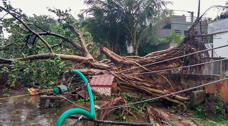
 Cyclone Phethai Highlights: Exposed roots of an uprooted trees as Cyclone Phethai barrels through coastal Andhra Pradesh. (PTI)
Cyclone Phethai Highlights: Coastal areas in Andhra Pradesh were battered with heavy rains Monday, leaving several trees and electric poles uprooted and claiming the life of one person. A boat carrying seven fishermen went missing in the Bay of Bengal off Visakhapatnam, even as Phethai crossed the coast in East Godavari district and moved towards Odisha, PTI reported.
Chief Minister N Chandrababu Naidu, who has been actively keeping a track of developments, was apprised of the situation during a review meeting late last night. The Indian Meteorological Department in a statement said that the Deep Depression over Coastal Andhra Pradesh moved nearly northwards with a speed of 11 kmph and gradually weakened into a depression.
Sixteen teams of Andhra Pradesh Disaster Response and Fire Services were deployed in and around Rajamahendravaram, while another nine (of five members each) have been in West Godavari district for road clearance. East Godavari district bore the brunt of the storm as it made landfall near Katrenikona, forcing the evacuation of 20,000 people, who have been sheltered in relief camps.
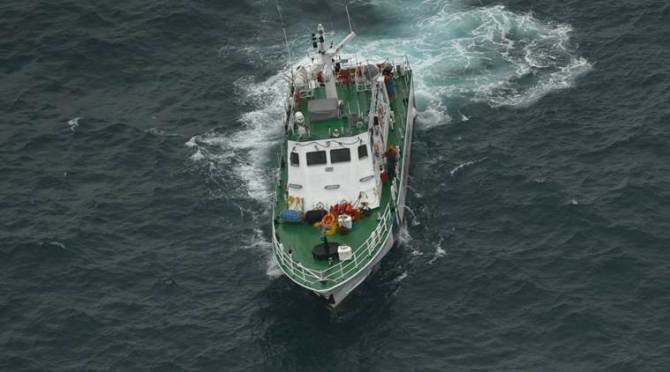 Indian Coast Guard has been put on alert. (AP Photo)
"We shifted the people because it is dangerous staying in half-constructed houses during the calamity," the official said. Rainfall, accompanied by strong surface wind, lashed several parts of Malkangiri, Koraput, Gajapati, Ganjam, Rayagada and Kalahandi districts, the Met office said.
While inclement weather affected normal life in many parts of south and western Odisha, no casualty was reported, a senior official said, adding power supply was disrupted in some areas. As many as 11,600 people were evacuated in Gajapati district even as houses ravaged by Cyclone Titli in October are yet to be fully repaired, a senior official at the Special Relief Commissioner's (SRC) office said.
The India Meteorological Department (IMD) has forecast isolated heavy to very heavy rainfall in south Odisha and heavy rainfall in the western region till Wednesday as the cyclonic storm weakened gradually. "The depression over north coastal Andhra Pradesh moved in the north-north-east direction and weakened into a well marked low-pressure area and lay over north-west and adjoining west-central Bay of Bengal and Odisha Tuesday morning," Director of the Meteorological Centre here, H R Biswas said.
The Met department has forecast generally cloudy sky with a few spells of rain or thundershowers in the city till Wednesday morning.
The weather is likely to improve from Wednesday morning in West Bengal as the well-marked low-pressure will further weaken into a low-pressure system and move to the north-eastern states, where it will cause heavy rain at isolated places, the Met department said. The weatherman forecast light to moderate rain in most places of Gangetic West Bengal and in some places ofSub-Himalayan West Bengal.
Satellite imagery shows the cyclone weakening in its path is now over Odisha. The wind speeds have also come down and the cyclone has lost its intensity.
Strong wind speed reaching 30-40 kmph gusting to 50 kmph likely along and off Odisha coast and over northwest & adjoining west-central Bay of Bengal during next 12 hours.
Though the cyclone system has weakened, many districts in the southern region of the state have been experiencing heavy rainfall under its impact. As per the latest information from IMD, heavy to very heavy rainfall is likely in Malkangiri, Koraput, Gajapati and Rayagada districts. Besides, isolated places in Gajapati, Ganjam, Rayagada and Kalahandi districts may also experience heavy rainfall, the IMD said.
Odisha government has evacuated more than 11,000 people to safety zones. "We have evacuated about 11,600 people in Gajapati district as their houses are yet to be repaired after Cyclone Titli in October this year," a senior official at the Special Relief Commissioner's (SRC) office said. People from seven vulnerable blocks in Gajapati district have been taken to safe places.
The Depression over North Coastal Andhra Pradesh moved nearly north-northeastwards during past 06 hours, weakened into a well-marked low-pressure area and lay over Northwest & adjoining West-central Bay of Bengal and Odisha: IMD
The cyclone uprooted several trees and damaged electric poles in Kakinada and adjoining areas as winds up toing upto 100 kmphn ravaged the coastal Andhra.
(PTI)
A man named R Durga Rao aged 28 was killed when a loosened soil hurtled down a hillock following heavy rains in Vijayawada city, according to sources in the state's disaster management Authority. Krishna district Collector B Lakshmi Kanthamannouncednan immediate relief of Rs 50,000 to the deceased family.
Naval Aircraft are standby at INS Dega to undertake Aerial survey with first opportunity of clear weather to assess the extent of destruction.
As Cyclone Phethai made landfall, RTGS ensured that basic facilities were made available to citizens & immediate measures were taken towards any reported issues. According to feedback through IVRS calls, 99.28% people were alerted about the cyclone, 99.36% received food & water: CM Naidu
State HRD Minister Ganta Srinivasa Rao apprised Chief Minister N Chandrababu Naidu of the situation during a review meeting the latter conducted late in the night at theReal-Time Governance Centre (RTGS) at the state Secretariat.
The deep depression over coastal Andhra Pradesh moved nearly northwards with a speed of 11 kmph during and weakened into a depression. It is very likely to move north-north-eastwards and further weaken into a well marked low pressure area, IMD said in a statement.
Meanwhile, in the wake of cyclones and storms, Tamil Nadu government today provided eighty fishing boat groups with 200 ISRO developed satellite-enabled communication devices that will provide them real-time alerts on cyclone and weather updates. Chief Minister K Palaniswami distributed the gadgets to seven fishermen from Chennai, Nagapattinam and Kanyakumari engaged in deep sea fishing, marking the rollout of the devices, at the Secretariat here. Touted as the Indian version of the American GPS (Global Positioning System), the NavIC (Navigation with Indian Constellation) enabled communication devices provides fishermen with real-time updates. (PTI)
The state government has arranged for resettlement from the affected areas and arranged for rehabilitation of 4014 people in 224 schools.
Andhra Pradesh Deputy Chief Minister (Home) N China Rajappa is camping at Bhairavapalem village in East Godavari district to oversee relief and rescue operations. Chief Executive Officer of the RTGS Babu Ahamed said precautionary steps taken by the authorities had minimised damage to life and property. He said trees were uprooted in some 20 places and rescue teams had cleared the debris in 15. Spare electric poles were kept ready, he said. (PTI)
Disaster teams clear drains and roads in various villages of Andhra Pradesh.
Cyclone Phethai has further moved northwards and is expected to to weaken across the Andhra coast today late evening.
The Phethai storm is crossing the coast between Andhra town Yanam and Kakinada, as authorities are alert and concerned about the safety of people to ensure no loss of life, tweeted the official account of the East Godavari district which is handled by the government of Andhra Pradesh. State CM Naidu tweeted that he has been instructed to beef up the rescue operations in areas where the storm surges as he takes up the responsibility in case of a disaster situation.
The RTEGS in Andhra Pradesh estimated that heavy rains in the 22 zones would be huge in the backdrop of crossing the Pethai coast. Accordingly Andhra CM Chandrababu Naidu ordered the collectors of the respective districts to move people to safer areas.
The cyclone storm moved northwards from the Bay of Bengal and is soon to form into a cyclonic storm with a wind speed of 70-90 kmph, furthering more.
Mild to heavy rainfall may hit neighbouring states of Odisha, Jharkhand, Chhattisgarh and West Bengal as well as the Gangetic plain. A wind warning has been issued along Andhra Pradesh, north Tamil Nadu, Puducherry and south Odisha coasts. As sea conditions are likely to be rough, and a storm surge to the height of about 0.5 m to 1.0 m is expected to hit areas in Andhra Pradesh and Puducherry. Fishing activities along the coast in these places have been suspended.
Post-landfall, Naval helicopters & aircraft will be flown to undertake an aerial survey for relief & rescue operations, says CG Raju, PRO Eastern Naval Command
Air traffic to the port city of Visakhapatnam has been hampered due to turbulent weather conditions, following which some flights were diverted to Hyderabad. A holiday has been declared for educational institutions in the coastal districts of the state as a precautionary measure. (PTI)
One person was killed in a landslide caused by heavy rains in Vijayawada city but no other casualties have been reported from elsewhere so far, according to sources in the State Disaster Management Authority. (PTI)
Cyclone 'Phethai' makes landfall in East Godavari district of Andhra Pradesh bringing moderate to heavy rains even as normal life remained hit in the coastal districts of the state.
NDMA in a short video advisory informs people about how to ensure safety ahead of Cyclones. Andhra Pradesh is gearing up to face Cyclone Phethai.
Andhra Pradesh Minister Nara Lokesh: We are bracing up to face Cyclone Phethai. Response teams and officials numbering more than 10,000 are stationed as part of disaster preparedness. Hoping that the loss of life and property will be minimal. (ANI)
The Indian Metereological Department released the satellite imagery of the vortex of Cyclone Phethai. The cyclone headed towards Andhra is of the severe category, however, is likely to lose intensity upon landfall.
The Odisha government has already asked district collectors to take steps to protect paddy from the unseasonal rain. Fishermen were advised not to venture into deep sea areas of west-central and adjoining south-west Bay of Bengal till Monday.
The system is likely to cause widespread rain in all districts of Gangetic West Bengal, with heavy rain in one or two places till Tuesday morning, the Met department said.
In West Bengal, heavy rain is likely to occur over one or two places in Howrah, East and West Midnapore, Purulia, Bankura, West Burdwan, Jhargram and Hooghly district on Monday. Strong wind, with speeds reaching 30 to 40 km per hour is likely to blow over northwest Bay of Bengal, the Met said in its forecast. (PTI)
Four districts in South Odisha have been experiencing rain since Sunday evening due to the cyclone, while Gangetic West Bengal is likely to experience heavy rain till Tuesday morning, the meteorological (Met) department said. South Odisha districts such as Koraput, Malkangiri, Raigada and Gajapati have been experiencing rainfall along with strong surface wind since Sunday evening, the officials said. (PTI)
The sea condition is very high to high over westcentral Bay of Bengal around system centre. The sea condition is very likely to be high over the west-central Bay of Bengal and along & off central Andhra Pradesh coast and Yanam district of Puducherry during next 12 hours. It will be very rough along and off remaining parts of Andhra Pradesh coast and rough to very rough along and off north Tamilnadu and Puducherry coasts during the same period.
We are fully equipped with the RTEs assessing the impact of the Pethai effect. We are directly reviewing the situation for every hour to keep the 48 hours up to date. Let's face this problem that comes to the state, CM Chandrababu Naidu tweeted.
The cyclone will make landfall between 14.30 to 17.30 hours at Kakinada. The area has been preparing to face the crisis and NDRF has been deployed in the coastal regions.
Satellite image of the Cyclone ravaging towards the south-eastern part of India.
Due to unfavourable environmental conditions, it is likely to weaken before landfall and cross the coast as a cyclonic storm with a wind speed of 70-90 kmph.
The cyclonic storm is aided by wind speed of up to 100 kmph which s predicted to go up by 110 kmphn in the following hours.
Rainfall at most places with heavy to very heavy falls at a few places over coastal Andhra Pradesh & extremely heavy falls at isolated places over north coastal Andhra Pradesh (East & West Godavari, Vishakhapatnam, Krishna, Guntur, Vizianagaram & Srikakulam Districts) and Yanam district of Puducherry.