This is an archive article published on March 6, 2023
WRI identifies 5 open spaces along Mithi river to help mitigate floods
The river is infamous for being one of the primary contributors to heavy flooding in low-lying areas of Mumbai’s western suburbs during monsoon
Written by Pratip Acharya
Mumbai | Updated: March 16, 2023 01:22 PM IST
3 min read
Whatsapp
twitter
Facebook
Reddit
An official said the BMC is planting over 130 species of plants in the Marol plot, which will not only improve air quality but also mitigate flooding during peak monsoon. (Representational/File)
Listen to this article
WRI identifies 5 open spaces along Mithi river to help mitigate floods
x
00:00
1x1.5x1.8x
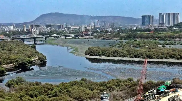
In a recent observation, the World Resources Institute (WRI) has identified five open spaces along the bank of Mithi river between Powai and Marol, which could be transformed into open urban spaces, bringing a solution towards flood mitigation in Mumbai. The WRI is set to submit the observation to the BMC, said WRI officials.
The 17-km long Mithi river originates from Powai lake and flows downstream, where it meets the Arabian Sea at Mahim Creek. The river is infamous for being one of the primary contributors to the heavy flooding in low-lying areas of western suburbs during monsoon. It pass through Bandra-Kurla Complex (BKC), Andheri, Kalina, Dharavi and Mahim.
WRI India is the knowledge partner to the BMC for the climate action plan of which urban flooding is a critical part.
Dr Kartiki Naik, programme manager of WRI, said, “At present, the authorities are implementing conventional flood mitigation methods like desilting or constructing a retaining wall along the banks of the river. These methods often contradict one another. Hence, we can make optimum use of the available land at the river bank in a way that could serve as a buffer zone for accumulated flood water.”
The report authored by Naik, along with Sahil Kanekar and Abhijit Waghre from WRI, said: “Along the course of the river, downstream of Powai Garden, the river passes through a natural, uninhabited area, and yet it is channelised. Instead, the river could be allowed to swell during heavy rainfall… to accommodate excess stormwater in floodable riverbanks. Such riverbanks, if naturalised, have the potential to improve accessibility to the river, biodiversity and habitat creation and river water quality in addition to stormwater management.”
Kanekar said, “Heavy rainfall persists for only 4-5 days during peak monsoon, so these land parcels could be used as a community garden and open space for rest of the year. The basic idea is to make Mithi river bank accessible… this will also improve the standard of living of people.”
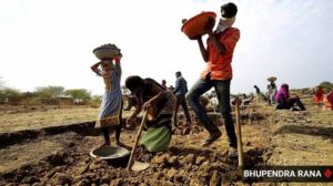
Last June, the BMC had identified a 3 acre on the bank of Mithi in Marol to set up an urban forest. Civic officials said this land was identified in a joint collaboration with WRI.
Story continues below this ad
An official said the BMC is planting over 130 species of plants in the Marol plot, which will not only improve air quality but also mitigate flooding during peak monsoon. “The forests are natural absorbers of rain water, as it allows the water to seep through from the roots and prevents it from flowing away. Now if more such spaces are developed adjoining the river, then flooding issues could be resolved to a larger extent,” said an official.
“Near the adjacent plot, we are creating an artificial water holding tank, which would not only store rain water but also sewage water and prevent the same from flowing into the river,” the official added.
Pratip Acharya is a seasoned journalist based in Mumbai reporting for The Indian Express. With a career spanning over a decade, his work demonstrates strong Expertise and Authority in critical urban issues, civic affairs, and electoral politics across Eastern and Western India.
Expertise & Authority
Current Role: Journalist, The Indian Express (IE), reporting from Mumbai.
Core Authority: Pratip's reporting focuses sharply on local democracy and development, specializing in:
Urban Governance and Civic Affairs: Providing in-depth analysis of municipal decision-making, city planning, and local infrastructure, essential for informed urban reporting.
City Politics and Environment: Covering the political dynamics of Mumbai and surrounding areas, alongside critical environmental challenges impacting the metro region.
Electoral Coverage (High-Stakes Experience): He has extensive experience in high-stakes political reporting, having covered major elections, establishing his Trustworthiness in political analysis:
National: Lok Sabha elections in 2014 and 2019.
State: West Bengal Assembly elections in 2016 and Maharashtra Assembly elections in 2019.
Major Assignments (Ground Reporting): Pratip demonstrated commitment during crises by conducting ground reporting throughout the Covid-19 pandemic since its breakout in 2020, offering first-hand accounts and analysis of the public health crisis.
Experience
Extensive Experience: Starting his career in 2014, Pratip has built his foundation across multiple prominent English dailies:
Started at The Times of India in Kolkata (2014).
Relocated to Mumbai (2016) and worked with The Free Press Journal and Hindustan Times before joining The Indian Express.
Pratip Acharya's diverse experience across major publications, coupled with his specialized focus on the intricate details of urban governance and a track record of covering major electoral and health crises, establishes him as a trusted and authoritative source for news from India's critical metropolitan centres. ... Read More