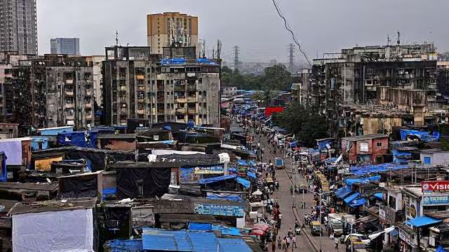
The Dharavi Redevelopment Project’s transport and infrastructure master plan aims to transform the 251-hectare settlement into a well-connected, transit-oriented urban zone, with emphasis on decongestion, multi-modal integration and inclusive public spaces.
According to the project presentation given to the government on Wednesday, a copy of which is with The Indian Express, Dharavi’s location — at the intersection of east-west and north-south transit corridors — positions it strategically as a city-level transport interchange. The site lies close to Mumbai Metro Line 3, both the Western and Central suburban railway lines, and is just under 3 km from the upcoming Mumbai–Ahmedabad High-Speed Rail terminal at Bandra Kurla Complex.

Multi-modal transport hub planned
A central element of the plan is the creation of a multi-modal transport hub (MMTH), which will integrate Metro corridors, suburban rail access, bus services, and feeder systems. The hub is designed as a two-level structure — the lower level accommodating buses and taxis, while the upper level will serve Metro Line 11 and a proposed spur of Line 8.
Within the internal layout, a fine-grained street network is planned to improve accessibility for pedestrians, cyclists, and non-motorised transport (NMT) users. This network is designed to vary based on final plot configurations and will be integrated with open spaces and transit nodes to ensure safe, intuitive movement through the area.
The goal is to establish a walkable urban fabric, with public amenities accessible within a 5- to 15-minute walk for all residents.
The transport plan proposes a vehicular circulation strategy that discourages through-traffic on internal roads—reserving them primarily for local access and services. Given the existing congestion at entry points and the additional traffic projected due to redevelopment, seven new entry and exit routes have been proposed.
These include:
1. An underpass from Takandas Kataria (TK) Marg to 90 Feet Road
2. A new connection to Senapati Bapat (SB) Marg
Story continues below this ad
3. Link from Dharavi Depot Road to Chunabhatti–BKC Link Road
4. Underpass below the Harbour Line
5. Road connection along the Western Railway to Mahim-Sion flyover
6. Underpass below the Harbour Line near Mahim to SB Marg
7. Underpass below the Central Line to Sion
These will supplement existing entry points and are expected to help disperse vehicular loads more efficiently across the area.
Green spaces and open areas
Reclaiming nature within one of Mumbai’s densest areas is another focus of the plan. The masterplan lays out a connected and inclusive network of green and open spaces through three key strategies: The Green Spine (a central ecological corridor), The Central Park (a public recreational zone), and The Waterfront (a landscaped leisure space).
Story continues below this ad
This landscape strategy, the presentation notes, aims to “balance environmental restoration with everyday community use” through a hierarchy of open spaces.
Strategy for religious structures
As per a 2009 Mashal survey, Dharavi houses 296 religious structures, including temples, mosques, dargahs and churches. The government has initiated a process to survey and map all such structures under the Dharavi Redevelopment Area.
A committee—constituted via a 2024 Government Resolution and chaired by a former Chief Justice of the Allahabad High Court—will oversee decisions related to the eviction, relocation or regularisation of unauthorised places of worship.
Structures constructed before September 29, 2009, will be evaluated for possible regularisation under existing government rules. The final decisions will be made based on the recommendations of the committee in consultation with local communities, as per the master plan.
Story continues below this ad
Industry clusters will also be created. Despite being a slum, Dharavi is considered to be a vital industrial zone, home to a variety of small to mid-scale sectors and forms an essential part of the city’s export framework. The master plan also envisions rehabilitation of the existing manufacturing and retail industries.
The master plan states that a tentative clustering has been planned for the industries that are located in Dharavi. It has planned to make five industry clusters—garment, pottery, leather, food and recycling, all of which will be in the redeveloped area.
With mobility, environmental design and social infrastructure as core priorities, the Dharavi redevelopment seeks to create a framework for a more connected and equitable urban future.