Gujarat gets on to Agri Stack, starts digital crop survey
The digital survey is expected to eventually replace the existing system of estimating crop sowing areas based on ocular observations of gram sevaks and provide the government with a realistic picture of various crops.
 Surveyors conducts digital crop survey in Toraniya village of Dhoraji taluka of Rajkot district on Sunday. (Photo courtesy of agriculture department, Gujarat government.)
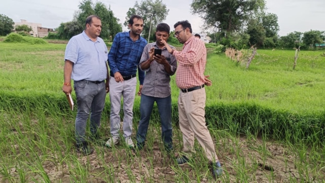
In a major move, the Gujarat government has started a digital survey of crops sown in each of around one crore plots of agricultural land in the state to generate accurate data about crops and get real-time details of sowing. Officers said the digital survey will eventually replace the existing system of estimating crop sowing areas based on ocular observations of gram sevaks and provide the government with a realistic picture of various crops.
Officers said that the survey started on Friday as part of the initiative of the central and state governments to create a digital infrastructure that will help farmers and governments simultaneously. Tech-savvy youths in villages are being roped in through outsourcing to conduct this massive exercise using the Agri Stack application, a mobile phone-based application developed by the Centre.
 Digital crop survey in progress in a village in Gujarat on Friday. (Photo courtesy of agriculture department, Gujarat government.)
“Land records of the state have been fed into the Agri Stack platform in digital form. In those records, each survey number or plot of agricultural land has a geo-reference. The surveyor can access details of a survey number only if he goes on that plot. Once the surveyor is on a given platform, he will enter into the app details of the crop actually sown in that plot and will also take photos of the crop with location details and upload them on the app for validation,” a senior officer of agriculture, farmers welfare and cooperation department told The Indian Express.
 Digital crop survey in progress in a village in Gujarat on Friday. (Photo courtesy of agriculture department, Gujarat government.)
Gujarat generally records sowing in around 90 lakh hectares during the Kharif season. The southwest monsoon generally hits Gujarat in mid-June and Kharif sowing season starts afterwards. “But digital crop survey has to be undertaken when crops reach the vegetative growth stage during which they are easily identifiable. Therefore, we have started the exercise in mid-August and plan to conclude it tentatively by the end of this month,” said the officer.
The officer said the digital crop survey will generate “accurate and reliable real-time data which can be validated”.
“Presently, gram sevaks (village level workers or VLWs) sent weekly updates on sowing progress. Therefore, there is always a time lag in sowing and the government’s weekly sowing reports. Digital crop surveys will provide accurate real-time data. So, in coming years, we will do away with the practice of preparing sowing estimates based on gram sevak’s reports,” said the officer, adding, “In the coming time, the details of digital crop survey will be available in the public domain.”
 Digital crop survey in progress in a village in Gujarat on Friday. (Photo courtesy of agriculture department, Gujarat government.)
The move comes a year after the state government conducted such a digital survey in more than 12.89 lakh plots in Kharif season and 9.50 lakh survey numbers in Kharif season in six districts last year as a pilot project. These six districts were Mehsana in the north Gujarat region, Aravalli in the eastern Gujarat region, Porbandar in the Saurashtra region, and Narmada, Dang, and Navsari districts in the south Gujarat region.
The state government’s gram sevaks are tasked with providing agricultural extension services to farmers. These VLWs send village-level sowing reports after estimating the sowing area of crops through ocular observations.
“But in practice, VLWs are not making ocular observations of all the agricultural plots in villages assigned to them. In many instances, VLWs meet a few farmers, make enquiries about what crop they have sown, and then extrapolate based on such sample information. Thus, the government doesn’t get a realistic picture of the area of crops. This leads to crop production estimates which are not very accurate,” a senior officer of the department said.
 Digital crop survey in progress in a village in Gujarat on Friday. (Photo courtesy of agriculture department, Gujarat government.)
“Such discrepant data means that sometimes, while official production estimates would be low, agricultural produce market committee (APMC) yards will be flooded with crops harvested by farmers.”
Raghavji Patel, Gujarat’s Minister of Agriculture, Farmers Welfare, and Cooperation, says the decision also aims to simplify farmers’ process of accessing government schemes, such as crop procurement at the minimum support price (MSP).
“Presently, talatis (clerks of revenue department at village levels) are not making entry of crops in panipatraks (Form No. 12) after farmers complete sowing. Therefore, when farmers want to sell their crops to the government at MSP, they need to go to a talati to have such entries made in their panipatrak and then upload details of the panipatrak at the time of registration for the MSP scheme. But in the digital survey, details of crops sown by a farmer will be available as a data pool to which talatis will have access and entry in panipatraka will be done automatically,” Patel told The Indian Express.
The minister said the digital survey would also help the government make decisions. “The digital survey will give a clear picture of crop area. This will help the government make proper decisions,” he said.
The government will pay Rs 10 to the surveyor for each survey plot surveyed. “The central government will provide 60 per cent funding for this project while the state government will bear the remaining 40 per cent,” said the officer.
“Village computer entrepreneurs will be our first preference as surveyors. But suppose they are not available or willing to do the job. In that case, we are identifying tech-savvy youths from concerned villages with the help of village sarpanch and talatis,” the officer added.
You May Like


Photos