Flood effect: Surat civic body removes culverts, low-level bridges from creeks to ensure smooth water flow
The irrigation department has been instructed to carry out a survey of the creeks and submit a detailed project report to the committee within the next 10 days
 Sources said that three creeks — Mithi, Bhedwad and Kakra — pass through the city. Of these, Mithi is the longest creek, running through various areas in the town and later merging with the Mindola river (Express)
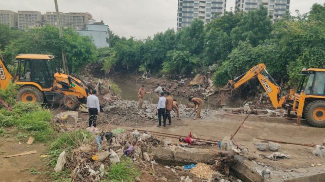
Following widespread damage recently caused by the floods in Surat, and to mitigate the impact of the annual menace during monsoon, the Surat Municipal Corporation (SMC) has begun an exercise to widen the creeks by removing structures along and over the water bodies, including culverts and low-level bridges, which have been found to be obstructing the flow.
The exercise, which kicked off Sunday, entered its second day on Monday.
Meanwhile, a meeting of the high-power committee for creek floods was held under leadership of Surat Municipal Commissioner Shalini Agrawal for the first time after the civic body chief took over the reins of the panel from District Collector Dr Sourabh Pardhi a few days ago.
Sources said that three creeks — Mithi, Bhedwad and Kakra — pass through the city. Of these, Mithi is the longest creek, running through various areas in the town and later merging with the Mindola river.
Sources in the SMC stated that the work has been completed in the Varachha B Zone, Udhna Zone, Limbayat Zone, and Athwa Zone of the civic body with deputy engineers and executive engineers put to work on Sunday – a holiday.
Sources said that an RCC bridge, which was in a dilapidated condition and was obstructing the flow of Mithi creek passing through Kumbhariya, Saroli, Sania Hemad, and Devadh in the South East (Limbayat) Zone area, was being demolished. Work on dredging out the demolition waste was also being carried out simultaneously, they added.
In addition, a fabricated bridge, 10 meters long and 1 meter wide, which was believed to be obstructing the flow of the creek at Godadara-Dindoli, passing through Godadara village and Krishna Park Society, was also removed on Monday.
Apart from this, cleaning work on the Kakra Creek has started in the South West (Seventh) Zone, downstream of the bridge connecting Bamroli and Althan areas. The creek narrows by around 50 to 60 meters towards the boundary and work has been undertaken to widen it, said sources. Creek realignment work in the downstream area from Bhimrad to Sachin Magdalla bridge is also being carried out.
In the Udhna Zone A area, the old pipe culvert structure located in front of Bamroli village at Vighneshwar Mahadev Temple, where Bhedwad creek passes, was removed by the officials. The creek area has been widened by removing the stones and other waste on both banks from Bhimrad to Bamroli.
Meanwhile, in the creek-flood prevention committee meeting, long-term and short-term steps that need to be taken to prevent floods were discussed, sources said.
The irrigation department has been instructed to carry out a survey of the creeks and submit a detailed project report to the committee within the next 10 days. The structures obstructing the creek water in the city and district, such as low-lying bridges and culverts, besides debris and other obstructions, should be removed by the SMC within municipal corporation limits, and by the Surat collector and irrigation department officials in Surat district areas.
If any private person constructs a bridge or any other structure on the creek, they would need to obtain permission from the SMC and the Irrigation Department, said the sources.
The Irrigation Department and Gujarat Pollution Control Board (GPCB) were asked to conduct a structural assessment and prepare a report on industries discharging waste directly into the creeks, sources said. The SMC commissioner said the pressure points on the flow of creek water should be noted and satellite images of these water bodies be taken, according to sources.
After conducting a survey, the irrigation department should submit a report identifying locations where dredging and desilting activities are to be carried out in the creeks, the civic body chief said. Besides, they were asked to identify areas where creeks become narrow and should be widened, said sources.
For long-term preparations, irrigation officials have been asked to prepare a database through GIS-based mapping and real-time monitoring of creeks.
SMC Commissioner Agrawal said, “We held a meeting with the members of the high-power committee. After discussions, instructions were given to the irrigation and other departments to carry out a survey, prepare a report and submit it to the committee so that further steps can be taken.”
Officials of Surat Urban Development Authority, Police and district Panchayat were also present on the occasion.
Last month, owing to incessant rainfall and resultant creek floods, low-lying areas in Surat were inundated.
You May Like


Photos