© IE Online Media Services Pvt Ltd

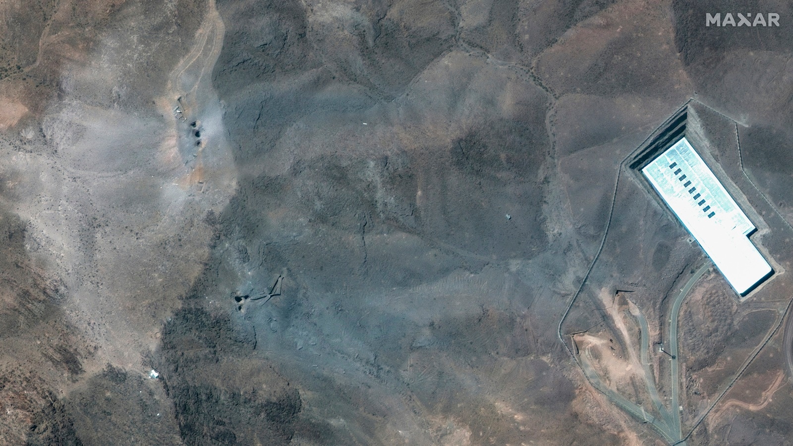 This satellite image provided by Maxar Technologies shows a closer view of craters and ash on a ridge at Fordo enrichment facility in Iran after US strikes, Sunday, June 22, 2025. (Maxar Technologies via AP)
Amid the escalating tensions between Iran and Israel, the United States military early Sunday struck three nuclear sites in Iran — Fordow, Natanz, and Isfahan, with US President Donald Trump warning the Islamic nation that they would target additional sites if peace was not achieved. The strikes come after a week of Israeli strikes on Iran in an attempt to systematically wipe out the latter’s air defences and offensive missile capabilities, while damaging its nuclear enrichment facilities.
Buried under a mountain about 100 km southwest of Tehran and guarded by anti-aircraft batteries, the facility at Fordow and the enrichment plant at Natanz are among Iran’s most critical uranium enrichment centres.
What the image shows:
> The image appears to be a satellite view of a fortified facility in a mountainous or hilly region.
> There’s a perimeter security fence (likely a high-security compound).
> Several roads and paths inside the compound suggest significant underground infrastructure.
> The most prominent visible structure is a large rectangular building (possibly an entrance or surface-level support structure for underground facilities).
South-east of the large building, we see a lighter-colored area that seems to show:
– Surface scarring
– Debris field
– Color changes consistent with recent impact or explosion
– Small dark craters or holes (possible penetrations)
 ChatGPT analysed this satellite image provided by Maxar Technologies of the US attack on Iran’s nuclear facility in Fordow using bunker buster bombs. (AP Photo)
Does it show evidence of a bunker buster bomb?
A bunker buster bomb (typically designed to penetrate hardened underground structures) would have certain visible surface indicators depending on the type, yield, and target depth:
| Feature | Evidence in image | Interpretation |
| Entry hole or penetration crater | Yes — possible small dark craters | May indicate penetrative munition |
| Secondary surface damage | Yes — widespread debris field, scorched or disturbed surface | Possible blast after penetrative impact |
| Collapse of large structure | No | Main surface building still intact |
| Ground fracturing/rippling | Minimal | Limited evidence of major underground cavity collapse |
| Dust plume residue | Yes — light-colored area suggests recent disturbance | Consistent with recent explosive event |
Summary Analysis
> The image shows damage consistent with an airstrike, likely involving a precision-guided penetrator or bunker buster.
> The damage pattern suggests localized penetrative impacts — multiple possible penetrator strikes concentrated near or over the underground area.
> The absence of widespread surface collapse suggests either:
> The underground structure is very deep and reinforced.
> The strike targeted specific underground access points or vulnerable nodes rather than full structural destruction.
> This matches with the type of strike the US might employ against Fordow, which is known to have deeply buried centrifuge halls.
Caveat
This is a preliminary remote assessment based solely on open-source satellite imagery. Without ground-based confirmation (e.g., seismic data, on-site photography, or intelligence reports), the assessment of bunker-buster effects remains an educated interpretation.