© IE Online Media Services Pvt Ltd
Journalism of Courage

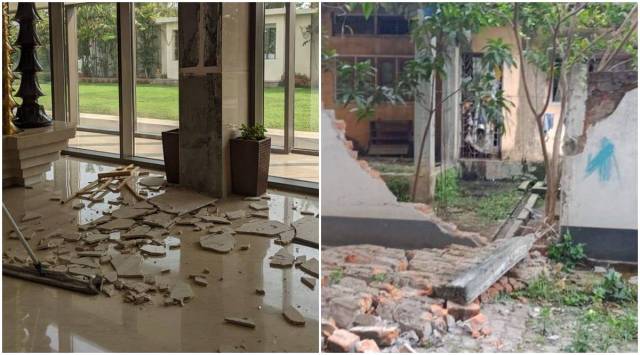 Few early pictures of damage in Guwahati.(Source: Twitter/@@himantabiswa)
At least 10 people were injured and several houses and buildings were damaged as an earthquake of 6.4 magnitude rocked Assam on Wednesday morning — followed by 10 aftershocks of magnitude range 2.9 to 4.7 till the evening.
“Big earthquake hits Assam. I pray for the well being of all and urge everyone to stay alert. Taking updates from all districts,” tweeted Chief Minister Sarbananda Sonowal.
Senior minister Himanta Biswa Sarma tweeted that the epicentre was in Dhekiajuli town in Sonitpur. “The massive 6.7 tremor in Assam has left people shell-shocked but luckily no casualties reported so far. Damages to buildings, properties & roads in certain areas reported besides water gushing out of fields witnessed. No reason to panic.”
Two persons died during the earthquake but the Assam State Disaster Management Authority said, “While no casualty resulting due to earthquake injuries reported but two persons (one each in Kamrup Metro and Nagaon districts) died due to shock /heart attack around the time of earthquake.”
Water seeping out from a paddy field in Narayanpur area of Dhekiajuli, the epicenter of the massive 6.7 earthquake in Assam pic.twitter.com/BOD6bfCp6s
— Himanta Biswa Sarma (@himantabiswa) April 28, 2021
Prime Minister Narendra Modi spoke to Sonowal twice. “I pray for the well-being of the people of Assam,” Modi tweeted.
Union Home Minister Amit Shah, Union Finance Minister Nirmala Sitharaman and DONER Minister Jitendra Singh also called Sonowal and took stock of the damage. All necessary help and support to the state government has been assured.
Sonowal, who visited Dhekiajuli on Wednesday evening, said the district administrations were directed to carry out a field survey of the damage, submit reports for a detailed review and extend necessary help and support to those affected.
The primary tremor on Wednesday morning has its epicentre at 26.690 N and 92.360 E and a focal depth of 17 km, according to a report by the National Centre for Seismology.
“The preliminary analysis shows that the events are located near to Kopili Fault closer to Himalayan Frontal Thrust (HFT). The area is seismically very active falling in the highest Seismic Hazard zone V associated with collisional tectonics where Indian plate subducts beneath the Eurasian Plate,” the report said.
The report said the “historical and instrumentally recorded earthquake data” showed that the region has been affected by “moderate to large earthquakes”, the most prominent among them on July 29, 1960 of magnitude 6.