Journalism of Courage
Premium
This is an archive article published on July 26, 2023
When it pours it floods: Why our cities fail the rain test
Record rains, swollen rivers, submerged homes, loss of lives and livelihoods, and traffic jams – cities and towns across the country come to a halt every monsoon. But why is it that our cities can't handle rains, and what is the way forward? The Indian Express spoke to urban planning experts across cities. Excerpts:

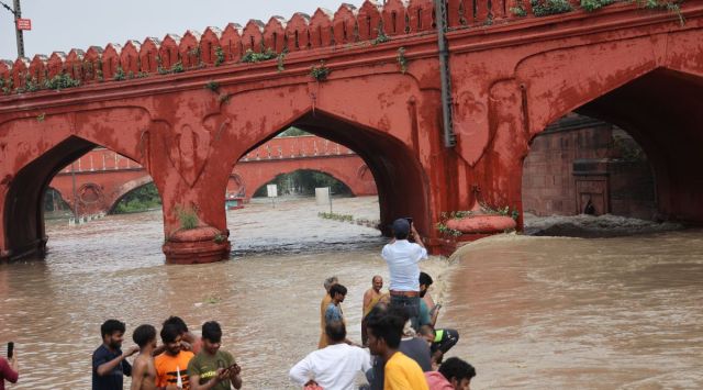 The water levels, which rose to 208.66 metres on July 20, led to Delhi’s worst floods on record, submerging the Ring Road and leaving Kashmere Gate, Civil Lines, ITO, and Rajghat waterlogged. (Express photo)
Listen to this article
When it pours it floods: Why our cities fail the rain test
x
00:00
‘Need a water management plan… Work with water, not against it’
The Yamuna recently breached its banks and flooded large parts of the city as heavy rains coincided with the release of water from the Hathnikund Barrage upstream, in Haryana. The water levels, which rose to 208.66 metres on July 20, led to Delhi’s worst floods on record, submerging the Ring Road and leaving Kashmere Gate, Civil Lines, ITO, and Rajghat waterlogged.

THE PROBLEM
There are three primary issues that are causing floods worldwide – climate change, urbanisation and reclaiming riverbeds, and deforestation. In Delhi, particularly, we have been developing low-lying areas along the riverbed for decades, be it bridges, underpasses or flyovers. In Seelampur, towards northeast Delhi, for instance, the Delhi Metro reclaimed over 65 acres along the river. Subsequently, there were other projects downstream including the Commonwealth Games village, Akshardham temple and Delhi Metro housing that came up. These have strained the riverbed, reducing its capacity to allow the flow of water.
Likewise, along East Delhi, the flood plains of the Yamuna have been reclaimed. The soil there is sandy, which absorbs water. But now, it has all been concretised.
In South Delhi, private development in areas such as Greater Kailash and South Extension ignored the lay of the land. The carrying capacity of our nullahs have shrunk. We have vandalised the land and haven’t given it due respect.
Mismanagement of water systems have further aggravated flooding in the city.
 The flooded area of Rajghat on July 17, when the water level of Yamuna rose slightly to 205.58 metres. (Express photo By Amit Mehra)
THE WAY OUT: Short-term measures will not help. There has to be a comprehensive water management plan that can be strategised quickly, on a war footing. It should look at the urban poor and the riverbeds, but above all, work with water, not against it.
Story continues below this ad
In the Delhi Master Plan, there are provisions for waste and sewage management, supply of drinking water and recycling water. Flooding, too, should be made a component. The 100-year-old flood line will need to be reviewed.
‘Bring the ‘public’ into public infrastructure… need ownership’
In a span of seven days in September last year, Bengaluru was marooned twice. While the September 5 rain that submerged the city was unusually high, the city has come to a halt with far less. In May this year, a heavy downpour that lasted just about an hour caused havoc in several parts of the city, claiming the life of a woman who died when the vehicle she was in submerged in the flooded KR Circle underpass.

THE PROBLEM
Bengaluru’s topography features an undulating landscape, highlighted by a central ridge extending NNE-SSW towards Cauvery and the Pennar rivers. This natural terrain should ideally be enough to facilitate smooth flow of water.
Inadequate engineering practices lie at the root of Bengaluru’s water management woes. The city’s Water Supply and Sewerage Board (BWSSB) has long neglected critical upgrades and a comprehensive infrastructure network. The issues are also systemic. Fragmented contractual responsibilities for maintenance, retaining walls, desilting, disposal etc., only exacerbate the issues plaguing this network. The primary function of the Rajakaluve is to channel surface run off and rain water into the connecting lakes. However their carrying capacity is impacted due to sewage, garbage as well as obstructions built into the drain. This is a classic example of the tragedy of the commons; public property is someone else’s problem.
Story continues below this ad
 Flooded KR Circle underpass where a 22-year-old woman died after her car got stuck on May 21. (Express photo by Jithendra M)
THE WAY OUT: In India, the infrastructure challenge often lacks eco-friendliness, but valuable lessons emerge from projects like the K-100 Citizens Waterway project in Bengaluru. By enhancing the sewage network across a 32-sq-km area, we discovered that instilling a sense of ownership encourages better preservation of public spaces. To prevent flooding, it is vital to involve the public in preserving and maintaining our infrastructure. Neglecting the drains undermines efforts to revive the lakes. The aim is to foster a sense of ownership and responsibility within society to safeguard our vital public infrastructure.
Furthermore, while the focus remains on reviving Bengaluru’s lakes, we must not overlook the critical role of the storm water drain network in replenishing these water bodies. It is a network which is crucial to the health of the city and its lakes.
Create risk maps, need an evacuation strategy’
During last year’s monsoon, several low-lying areas of Mumbai, including Sion, Parel and Dadar, came to a halt on most days between July and September, as rainfall exceeded the 50-mm mark. The Andheri subway, a chronic waterlogging zone of suburban Mumbai, was also shut for vehicular and pedestrian movement. This year too, areas such as Andheri have been facing severe waterlogging.

THE PROBLEM
Mumbai is on the coast, where moisture and winds enter. It’s the gateway of monsoon winds coming in from the side of the Western Ghats. Now, if this were a city with no buildings, the winds would flow freely. But in Mumbai, we have mixed-used development. Some places have slums, there are high and low-rise buildings, and then some places are hilly. So this leads to turbulence, resulting in more rain. So, in Mumbai, different pockets have heavy rainfall. For instance, if you go from Powai to Navi Mumbai, you will find heavy rains on the Eastern Expressway because there the wind can flow freely. This kind of uneven rainfall is very common in Mumbai, or any urban region.
Story continues below this ad
Now with concretisation in the city, water cannot percolate. But water has to flow out, and when there is high tide, and water cannot flow, it leads to flooding. This has been Mumbai’s problem. A few days ago, there was heavy rainfall (almost 203.7 mm at Santacruz), but because it did not coincide with high tide, there was minimal water logging.
Development has been random and uncontrolled, especially along riverbeds.
 In Mumbai, there is a need to make an assessment of our storm water drains and see if they are capable of handling excessive rain. (Express photo)
THE WAY OUT: We need to make an assessment of our storm water drains and see if they are capable of handling excessive rain. That should be part of any state-action plan.
We need to then improve early warning systems. While IMD gives us a forecast, it should also give a hind-cast. This means, over the last 10 years, if these kinds of monsoons have happened, what does the data show? With such information, one can have a mental model of how to act. So hindcasts and forecasts are necessary.
Thirdly, an evacuation strategy is important. From pumping out water and saving vulnerable people, we need to have a risk map that will tell you which are the vulnerable areas and how to move people quickly.
Story continues below this ad
In all this, there is also good news. With many positive initiatives by the BMC to pump out water quickly and clean up drains, water logging in many areas have reduced in the past few years.
‘We need stronger legal systems’
KOCHI & OTHER KERALA CITIES
Kerala witnessed its worst-ever floods in mid-August 2018 when low-lying areas and cities in four districts of central Kerala got submerged following days of torrential rains, coupled with the unexpected opening of dams in the higher ranges. Parts of Kochi, its suburban areas and several townships along the course of River Pamba remained submerged for days. Hundreds of people lost their lives in the calamity, reckoned as the worst in a century.

THE PROBLEM: Almost all of Kerala is urban. We have nearly 4,000 people per sq km, that’s roughly three times the national density. Also, our settlement pattern is like a farmstead – we may be urban but almost everyone looks for an independent plot of land with a well and some coconut trees. With this comes the problem of encroachment. The Kerala Master Plan does not have a demarcation for where one can build and where one cannot. That’s one of the primary reasons why floods happen.
Secondly, the geography of the land. If you drop a ball at the Western Ghats, it will roll all the way into the Arabian Sea. The land is full of contours. Traditionally, with the rains, the rivers would swell up and deposit slurry along the farmlands, making the soil fertile for farming.
Story continues below this ad
However, today, with unplanned buildings, the contours of the land are being ignored, both in macro- and micro-planning. The Cochin Airport at Nedumbassery is an example. It’s built along the flood plains of the Periyar, because of which with heavy rains, it gets flooded.
 Kerala witnessed its worst-ever floods in mid-August 2018 when low-lying areas and cities in four districts of central Kerala got submerged following days of torrential rains. (Express photo)
THE WAY OUT: We need strong legal systems in place to ensure future structures follow the lay of the land, allow water to percolate, and don’t narrow down streams. These days through technological simulations we can assess what buildings will do to flood prone areas, let’s do those studies before we build.
‘Make communities the custodians’
SHIMLA & HILL TOWNS
Since the onset of monsoon in Himachal Pradesh on June 24, over 150 people have died in rain-related incidents such as landslides, flash floods and cloudbursts, besides road accidents, according to the Himachal Pradesh State Emergency Response Centre.

THE PROBLEM: The Sixth Assessment Report of the United Nations Intergovernmental Panel on Climate Change (IPCC) mentions the vulnerabilities of the Himalayan states and coastal areas. Much of the flooding in recent years has to do with human-induced interventions.
Story continues below this ad
In Himachal, one has seen two major changes in development. First was in the 1970s, when the State played a role in social infrastructure. Every house had electricity but that abruptly ended in the post-liberalisation era, post ’90s.
While development was rapid, we had to generate our own money. For that, we turned to our natural resources – forests and its hydro potential. The World Bank came in and so did private players. But this was done at the cost of nature.
Many of these projects were along the rivers. Conduits were created and tunnels built, new technologies were introduced, and massive dams were built. But this completely finished us. And then, there was deforestation.
Tourism was the other attraction. Roads were extended, especially along the Shimla-Chandigarh and Shimla-Manali routes. Unlike what we have been doing in the past, when we earlier cut mountains, these were terraced so that we don’t destroy the entire ecology, now it’s a vertical slit, mountains are cut from top to bottom; it’ll take decades to restore these roads.
Story continues below this ad
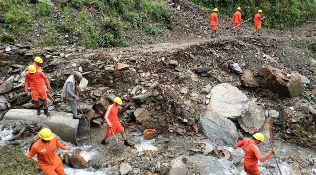 The Himachal Pradesh government had deployed SDRF and NDRF personnel to clear the roads amid flooding and landslides. (Express Photo)
THE WAY OUT: The answer to all this, I believe, is disruption – not what is to be done but how it has to be done. It’s putting people at the core. I’m asking for a commission of enquiry so that we can start discussions on what has gone wrong. I feel people should have the veto power – to say no to large dams, have a say in the industries we want and what kind of tourism we should have.
There should be new paradigms of the architecture of governance. Communities should be made custodians and some kind of insurance model should be developed, so that we don’t have to go to MLAs when such a crisis happens.
Advertisement
Top Stories


Live Blog
Advertisement
Loading Taboola...
Advertisement