Journalism of Courage
Premium
This is an archive article published on August 4, 2024
A glimmer: In Munnar, team forecast landslides — and averted damage
“Every site presents a different challenge. Different kinds of sensors are needed. Every site needs to be studied individually,” said K J Ramesh, former head of India Meteorological Department (IMD).

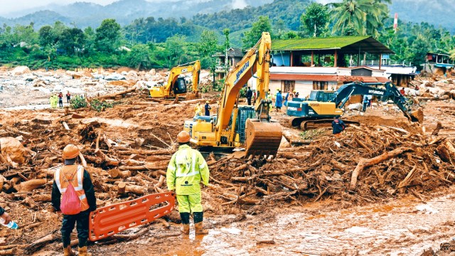 Rescuers hold a stretcher as the search for survivors continues after several landslides hit the hills in Wayanad district, in the southern state of Kerala, India, July 31, 2024. REUTERS
Barely two weeks before the devastating Wayanad landslide, a series of landslide incidents happened 300 km south in Munnar in Kerala’s Idukki district. Their scale was much lower but another reason these didn’t cause much damage was because they were predicted — allowing for pre-emptive action, including evacuation of at-risk populations.
This response by the Idukki district administration came partly on the advice of a team of researchers from Amrita Vishwa Vidyapeetham which has been testing an early warning system for landslides at a few sites in Munnar.
“It may not be possible to predict all kinds of landslides with pin-point accuracy but many of them can indeed be forecast and an effective early warning system developed. We have been working on this since 2009, and have shown that this is possible,” said Maneesha Vinodini Ramesh, the lead researcher on this project at Amrita Vishwa Vidyapeetham, told The Indian Express.
Unlike earthquakes, for which prediction science is not yet available, landslides, at least those triggered by rainfall, can be forecast a few hours in advance. The challenge is that landslides are highly localised events, and are dependent on a variety of local characteristics like topology, terrain, soil type, and also aggravating factors like rainfall, the most common trigger.
“Every site presents a different challenge. Different kinds of sensors are needed. Every site needs to be studied individually,” said K J Ramesh, former head of India Meteorological Department (IMD).
Current forecasts by IMD are very generic and not actionable. A forecast for heavy rainfall in a vulnerable area is almost invariably accompanied with a warning about the possibility of landslides getting triggered. But much more needs to be added to make it meaningful.
“At many sites in Kerala, including the one in Wayanad where the landslide happened, the terrain has two distinctive layers. A layer of soil sits atop a layer of rocks. When a lot of rain happens, the soil gets saturated with moisture and water percolates down and starts to flow between the soil and rock layers. This weakens the force that binds the soil to the rocks, and results in movement of the land,” said K S Sajinkumar, an assistant professor of Geology at the University of Kerala.
Story continues below this ad
For an effective warning system, therefore, besides “static parameters” like slope incline and soil characteristics, Sajinkumar said, what’s needed is information on the “thresholds” for saturation. “How much rains would lead to saturation of the soil? The thresholds would be different for different sites. Then one needs to assess the damage potential of the landslide, so that false alarms are minimised. Therein, lies a bigger challenge. The run-out areas (the route along which the landslide is expected to unfold) need to be calculated, and that is an extremely complex task.”
Maneesha’s team has accomplished much of this at its experimental sites in Munnar and another one in Sikkim in the form of a four-level early warning system.
The first level provides a regional forecast, the probability of a landslide happening over a 15-km zone. The second level provides site-specific information, using dynamic data from several parameters. This happens when potentially dangerous activities like soil slips are detected. “At this level, the information gets actionable. In Munnar, we had alerted the district and disaster management authorities at this second stage,” said Maneesha. “The third stage is the integration of artificial intelligence and machine learning models with rain forecasts to assess the likely impacts. The last part of warning happens when the landslide has just started. We are able to capture this in real-time. Much of the response, including evacuations, has to happen at second and third stage. Depending on the site, a lead time of about three to 30 hours is available.”
A three-hour lead time is extremely valuable in saving lives and minimising the impact of a disaster. The tsunami early warning system developed by India has a response time of just half an hour. It gets triggered once an earthquake in the relevant area of the ocean is detected.
Story continues below this ad
Maneesha, who also happens to be director of the Amrita Centre for Wireless Networks and Applications, said her team had demonstrated that landslide prediction was a solvable problem.
Explained
Local works, larger challenge
About 13% of India’s landmass, 0.42 mn sq km, is prone to landslides. These have thousands of individual sites, each one with unique local characteristics. Early warning systems are limited in applicability to local conditions and a large-scale landslide prediction model is a challenge.
“Landslide prediction is an interdisciplinary science. A lot of people and institutions with expertise in hydrology, meteorology, geology, computer sciences have to come together and work with local authorities and disaster management experts. You cannot be looking at only one trigger. For example, if one relies only on rainfall threshold levels, there are likely to be many false alarms. But the key thing is that it is a solvable problem. Landslide frequency is on the rise. Earlier, it required three or four days of continuous rains to trigger a landslide. These days, an equivalent amount of rainfall happens in a matter of few hours. We cannot afford Wayanad kind of disasters. We need to invest heavily into early warning systems,” she said.
G Sankar, a former senior scientist with Thiruvananthapuram-based National Centre for Earth Science Studies, said Maneesha’s team has done “commendable work,” but the task to develop an operational early warning system is cut out. “A lot of more work needs to be done, in studying the site-specific characteristics, assessing individual thresholds and pore-pressure models, installing a variety of sensors, some of which are very expensive, and in developing run-out models. The good thing is that work is already happening, and I am sure this current disaster will expedite things so that such incidents don’t get repeated,” Sankar said.
Landslide-prone areas in India have been mapped out in great detail. About 0.42 million square km area, amounting to about 13 per cent of India’s total landmass, is prone to landslides, according to the National Disaster Management Authority. Most of these sites lie in the Himalayan states, the Northeastern region, and the Western Ghats.
Advertisement
Loading Taboola...

Live Blog
Top Stories


Advertisement