Journalism of Courage
Premium
This is an archive article published on May 15, 2023
‘We can’t jump into conclusion by likening heatwave to climate change; monsoon to hit June 10-11’
THIS YEAR, the Indian Meteorological Department (IMD), has issued heatwave warning nearly four times for Mumbai, as well as for several districts of Maharashtra in the past two months. At a time when the country and the world is experiencing adverse and extreme weather phenomenon, SUNIL KAMBLE, scientist and head of IMD, Mumbai and Regional […]

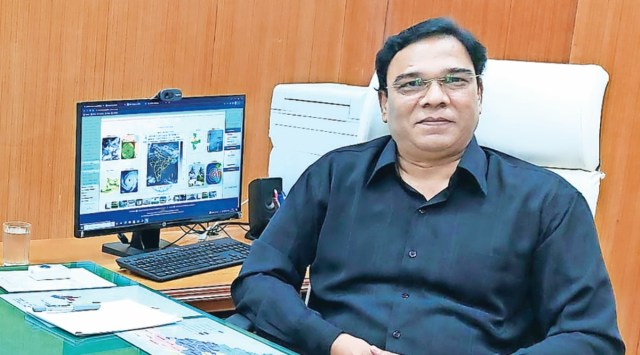 Sunil Kamble, scientist and head of IMD, Mumbai and Regional Meteorological Centre (Western India)
Listen to this article
‘We can’t jump into conclusion by likening heatwave to climate change; monsoon to hit June 10-11’
x
00:00
THIS YEAR, the Indian Meteorological Department (IMD), has issued heatwave warning nearly four times for Mumbai, as well as for several districts of Maharashtra in the past two months. At a time when the country and the world is experiencing adverse and extreme weather phenomenon, SUNIL KAMBLE, scientist and head of IMD, Mumbai and Regional Meteorological Centre (Western India) speaks with PRATIP ACHARYA on the causes of heatwave and why it is too early to attribute it to climate change.
The IMD has issued heatwave warning for Mumbai and Maharashtra nearly four times in the past two months. Why is it that the frequency of heatwave has increased this year?
The heatwave phenomenon is influenced by the wind pattern and interaction of dry and wet winds. When strong easterlies blow, there is a significant rise in temperature. Similarly, whenever there is a delayed settlement of westerlies (winds blowing from sea) it also results in increasing temperature. Over the past few days, we have observed that the westerlies are only being able to get settled around 10.30-11 am in the morning. By this time the day temperature has already risen and naturally it takes more time for the overall weather to cool down… Also, we live close to the Arabian Sea, which is a low-pressure zone and whenever a high-pressure develops in our region, it also leads to higher temperature levels.
Is the frequent heatwave like conditions result of climate change?
We cannot jump into the conclusion by likening the heatwave to climate change. Climate change is a long-term phenomenon and if the pattern of heat wave that we are seeing right now continue for a prolonged period, then we can attribute it to be a resultant of the climate change. For the time being, we are attributing it to a common weather phenomenon, since this is something we are seeing in the past few years and has not become a regular occurrence yet.
Last month, nearly 14 people lost their lives due to heatstroke in the Kharghar incident. Since the IMD didn’t have any operational weather monitoring station there, an alert couldn’t be given in advance. What are we doing to solve this?
We (IMD) are already in the process of setting additional Automatic Weather Stations (AWS) in some of the unrepresented areas in the state, through which we will be able to get a diverse knowledge of the weather patterns in Maharashtra and will also be able to predict possibility of any extreme weather event. At present, we are in talks with the state government to provide us with land parcels for setting up these stations. Our primary idea is to set up a minimum of four AWS stations and around 10 rain-gauge monitoring systems in the first phase at some of the unrepresented locations in Thane, Navi Mumbai, which currently doesn’t have any existing weather monitoring system in place.
Story continues below this ad
What will be the monsoon like in Maharashtra this year?
In our Long-Range Forecast (LRF) that we have issued during April this year, we have said that Maharashtra will experience normal monsoon up to 96%. This means that the state will see usual rainfall with an average prediction of 87 mm. The monsoon will hit Mumbai on June 10 and 11 as per the current LRF. How the monsoon will behave and when and how it will move northwards, we will come to know later this month.
During the budget session of the Assembly, Deputy CM Devendra Fadnavis warned of a drought-like situation that may hit certain parts of the state. Is there any possibility of something like this?
When we gave out the LRF, we have clearly stated that the state will experience normal monsoon up to 96%. However, it was also observed that La Niña is in neutral condition, which means that there is little possibility of deficient rainfall, that too in the rarest of occasion. This situation is not very alarming, because, we have a prediction of more than 90% normal rainfall across Maharashtra and in certain locations there may be a probability of rainfall deficiency by 30%, which is not very high. Again, for better safety and probability, we will be again updating our forecast by end of May, which will give us a clearer picture.
Story continues below this ad
Over the past one year, we have seen the frequency of extreme and unseasonal weather events increasing. Why is this happening?
The main reason is the pattern of interaction of winds. The weather system gets uplifted and the moisture goes above, where condensation takes places leading to hailstorm and heavy rain.
Mumbai’s water supply is entirely dependent on the rain… How will be monsoon in and around the catchment areas this year?
The possibility of giving a hyper-local forecast would be possible after the monsoon starts. If there is an even distribution of rainfall, then there will be no scarcity of water.
Advertisement
Top Stories


Live Blog
Loading Taboola...
Advertisement