Temperature dips in Himachal Pradesh amid incessant rain, Shimla under orange alert
Traffic hit in Shimla; IMD forecasts rainfall and gusty winds in most parts of Himachal for next 7 days.
 According to the Meteorological Centre, Shimla, light to moderate rain is expected in some parts of the state between May 2 and May 4.
(Express Photo)
According to the Meteorological Centre, Shimla, light to moderate rain is expected in some parts of the state between May 2 and May 4.
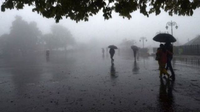
(Express Photo)Himachal Pradesh has recorded a dip in minimum temperature by 2 to 5 degrees due to the incessant rain in most parts of the state in the last 24 hours, with strong gusty winds blowing at 35 kmph to 67 kmph, according to the weather department.
Solan district received the maximum rainfall of 39 mm followed by 33.8mm at Ghaghas in Bilaspur. Shimla, which received 11mm rainfall on Thursday, received significant rainfall accompanied by thunderstorms on Friday morning as well, disrupting normal life. Traffic came to a halt on city roads, including Choota Shimla, Old ISBT-Shimla, and near Victory Tunnel as people preferred to travel on four-wheelers.
The India Meteorological Department (IMD), Shimla, has issued an orange alert for Shimla and Sirmaur districts and a yellow alert for Lahaul & Spiti for Friday.
The IMD has forecast significant rainfall along with gusty winds for the entire state in the next seven days.
According to the Meteorological Centre, Shimla, light to moderate rain is expected in some parts of the state between May 2 and May 4. Additionally, during the next four-five days, minimum temperatures across many parts of the state are likely to gradually fall by 2–5 degree Celsius. The maximum temperatures are also expected to drop gradually by 2–4 degrees Celsius in several areas, it said.
Divulging the weather details about May, an IMD officer said, “During May, the average maximum and minimum temperatures across most parts of Himachal Pradesh are likely to remain above normal. The lower hill-plains and surrounding mid-hill regions are expected to experience hotter-than-usual days. The rest of the state is expected to see days with temperatures near normal. Rainfall is likely to be above normal in many parts of the lower hill-plains and surrounding mid-districts, while near-normal rainfall is expected in the rest of the state.”
However, the state witnessed mixed weather patterns last month marked by sporadic rainfall, isolated hailstorms, and fluctuating activity levels. The overall precipitation for the month was notably deficient, contributing to one of the driest Aprils on record.
You May Like