Journalism of Courage
Premium
Why Sultanpur Lodhi’s Mand area faces floods after every rain: Inside Dhussi Bandh’s history and the people’s struggle
Ironically, Kapurthala district has received the highest deficit rainfall in the state to date

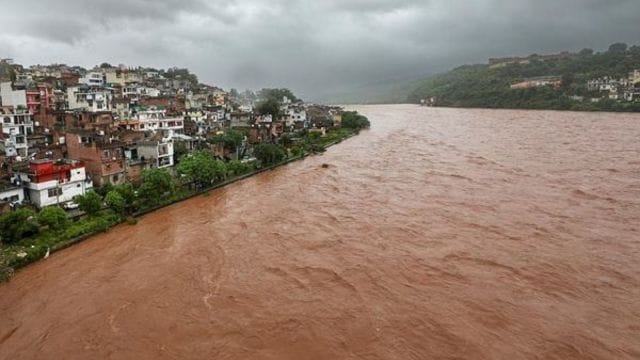 Around 10,000 acres in Sultanpur Lodhi Mand area and in the adjoining Tarn Taran and Ferozepur get affected badly with the swelling of the Beas. (PTI Photo)
Recurring floods in Sultanpur Lodhi’s Mand area, an island, almost every or alternate rainy season raise an obvious question: why do 16 villages on the island, as many villages by the river and over 10,000 acres of farmland drown, even if Punjab receives slightly above normal or even deficit rainfall?
This year, ironically, Kapurthala recorded just 22 mm rainfall in the past three days, and it still has a deficit of 45 per cent — the highest in the state, so far. However, villages in the Mand area have under water for the past around 10 days — even as Punjab recorded close to the normal rainfall — due to the heavy flow of water in the Beas river from the upstream and the Pong dam.
The answer lies in the topography and history of Dhussi Bandh, a protective embankment along the Beas, which has turned the Mand into a bowl holding water with no effective outflow, except for running towards Harike.
Inside Dhussi bandh
The Dhussi bandh was originally laid down in the 1950s on every perennial and even seasonal river of Punjab to protect the countryside areas close to the rivers. The objective of the Dhussi bandh on the Beas was to protect the downstream areas from the river’s unpredictable course. But, while the bandh protected several villages outside, around 30 villages inside the bandh, of which 16 fall on an island-type area and the remaining, along with the river inside the Dhussi bandh in Sultanpur Lodhi tehsil, remained exposed to backflow and inundation.
Around 10,000 acres in Sultanpur Lodhi Mand area and in the adjoining Tarn Taran and Ferozepur get affected badly with the swelling of the Beas. In Mand villages, the Beas now flows directly over around 3,000-4,000 acres.
Ownership and allotment — a history
Generally, it is believed that people living inside the Dhussi bandh are actually using the riverbed for their houses and farming, but the people in these over 30 villages claim that they are not using the riverbed and the land they have been cultivating is theirs. They also have proper documents like registries, intkaals and fards of the land as everything is theirs in the revenue record. “We are not using even a single inch of the river land. We are using land which is legally under our ownership,” said Kuldeep Singh Sangara of Sangara village in Mand area.
Sangara, the numberdar (head of the village) and the general secretary of the Hadd Peedit Kisan Sangarsh Committee, Punjab, said rather the Dhussi bandh was constructed in a manner that their villages fell inside it. “This has protected the people of the countryside living near the rivers, but the bandh pushed us inside. We are facing constant risk. Crops are often destroyed, livestock is endangered, and when it rains heavily, villagers face displacement,” he said. “We have organised a meeting with several intellectuals, who are supporting farmers on these issues, in Chandigarh today and presented our case, along with the ownership of our lands. We are not sitting on the river land as has been said. In September, a big gathering will be organised in Harike.”
People’s demand
Story continues below this ad
According to villagers, the Dhussi bandh cannot be dismantled as it protects the entire area outside the river, but they, led by local committees and groups, repeatedly petitioned the government. “Their demand is clear: permanent de-silting of the Beas, especially from Goindwal to the Harike stretch, where silt deposits have raised the riverbed and pushed water to the Mand area. A concrete rehabilitation plan for the 30 affected villages. A clear policy decision on the 10,000+ acres inside the Dhussi bandh that remain vulnerable,” Sangara said.
Why does the situation turn grim every year?
Experts point out that the Mand area has become a “flood bowl”: when the Beas swells, water is trapped inside the Dhussi bandh, while the embankment prevents natural drainage. Even moderate rainfall in upstream Himachal Pradesh or Punjab pushes water levels beyond safe limits, and breaches or overtopping flood vast tracts of farmland.
“Why should we drown every year just because of the way the Dhussi bandh was designed?” Sangara asked.
“The government must either de-silt the river or find a permanent solution,” locals said.
Story continues below this ad
The Harike lake is spread over around 4,100 hectares in several kilometres of area; its de-silting is a must, said villagers.
Drainage Department officials, on the other hand, said the land inside the Dhussi bandh is considered riverbed, and for de-silting, they said it is a technical work that requires a proper study.
Advertisement
Top Stories

Spanish company fires employee for repeatedly arriving 40 minutes ahead of duty time


Live Blog
Loading Taboola...
Advertisement