Journalism of Courage
Premium
This is an archive article published on July 31, 2024
A local agency warned of Wayanad landslides. Now it says more areas are susceptible
According to the Hume Centre for Ecology and Wildlife Biology, based in Wayanad’s Kalpetta town, multiple areas in the district — Lakkidi, Kappikkalam, Sugandhagiri, Thondernad, Kurumbalakotta and Manikkunnumala — can witness landslides if the heavy rainfall persists.

 As for the landslides at Mundakkai and Chooralmala early Tuesday, he said the Hume Centre had notified the possibility of landslides to the district administration on Monday based on rainfall data.
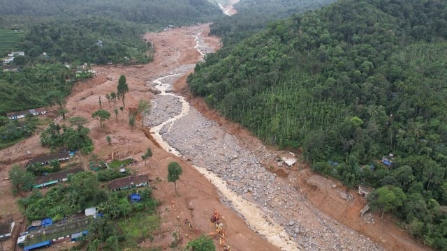
One day before the devastating landslides in Kerala’s Wayanad, an environmental organisation tracking local weather data flagged the potential disaster to the district administration. And now, it has warned of more landslides in the district this monsoon.
According to the Hume Centre for Ecology and Wildlife Biology, based in Wayanad’s Kalpetta town, multiple areas in the district — Lakkidi, Kappikkalam, Sugandhagiri, Thondernad, Kurumbalakotta and Manikkunnumala — can witness landslides if the heavy rainfall persists.
The alert is based on rainfall data the Hume Centre has at its disposal. It has mapped Wayanad into multiple 25-sq. km grids, placing at least one rain gauge in each grid. This gives it access to localised data that can be more useful than the macro-level data provided by the India Meteorological Department.
“Many regions in Wayanad have crossed 3,000 mm rainfall from the beginning of June 1. All the water bodies are heavily saturated. The dams are full. Any more heavy rain in such a circumstance can trigger landslides. The first one happened at Mundakkai. The other areas are equally prone to landslides,” C K Vishnudas, the director of Hume Centre and a conservation ecologist, told The Indian Express.
Tuesday’s landslides swept through several villages including Mundakkai and Chooralmala.
“Different regions have different threshold values, like 600 mm within two days or 900 mm within three days. If the rain persists like that there is a possibility of landslides in those regions based on our logistic regression model,” he said.
 All the regions the organisation has now warned of fall in the high-risk category. Their rainfall data from July 26 to 30 is as follows — Lakkidi: 790.4 mm; Kappikkalam: 682 mm; Sugandhagiri: 669.5 mm; Thondernad: 635.6 mm; Kurumbalakotta: 569 mm; Manikkunnumala: 547.6 mm
The Hume Centre has mapped Wayanad in collaboration with the Advanced Centre for Atmospheric Radar Research at the state-run Cochin University of Science and Technology.
Story continues below this ad
It has classified Wayanad into three zones of landslide susceptibility: High, medium and low.
All the regions the organisation has now warned of fall in the high-risk category. Their rainfall data from July 26 to 30 is as follows — Lakkidi: 790.4 mm; Kappikkalam: 682 mm; Sugandhagiri: 669.5 mm; Thondernad: 635.6 mm; Kurumbalakotta: 569 mm; Manikkunnumala: 547.6 mm
Lakkidi and Sugandhagiri recorded over 300 mm of rainfall on Tuesday alone.
Vishnudas said the Hume Centre has shared these inputs with the district administration. “We have a WhatsApp group with the district collector and district emergency cell staff. We post this information in the group. We personally inform the officials too. They are supposed to give the official warning. We generate data, interpret it and support the government machinery,” he said.
Story continues below this ad
As for the landslides at Mundakkai and Chooralmala early Tuesday, he said the Hume Centre had notified the possibility of landslides to the district administration on Monday based on rainfall data.
“Puthumala, where the nearest weather gauge to Mundakkai is situated, recorded 200 mm rainfall on Monday and a further 372.6 mm on Tuesday. This 572 mm rainfall within 48 hours was a huge factor behind the disaster at Mundakkai and Chooralmala beneath it,” he said.
Vishnudas does not believe that the data was ignored by the administration, but suggested that more people could have been evacuated.
“Even in this case, the local panchayat had informed people based on our inputs and a few people in areas above the Chooralmala school were evacuated before the landslides struck, is what I understand. Most of the casualties were from areas below the school,” he said.
Story continues below this ad
Back in 2020, the Hume Centre had helped avert a disaster in the same area. “We gave a warning in Mundakkai and people were evacuated. The next morning, there was a landslide, but not of this magnitude. There was no casualty.
But people suffered losses to property and agriculture,” said Vishnudas.
Besides data, he said, there are clues in the surroundings that can tip people off to the possibility of a landslide. “We have been telling people in landslide-prone areas to keep track of water streams to see if they are unusually muddied. That could be an early sign,” he said.
Evacuation is not a permanent solution, according to Vishnudas. “People in high vulnerable zones need to be relocated to safer places with state assistance.”
Story continues below this ad
Also, there is a need to empower local communities to mitigate natural calamities. “More proactive system with community participation is required. We need community climate managers in each locality, capable of giving early information to local people,” he said.
Advertisement
Top Stories


Live Blog
Advertisement
Loading Taboola...
Advertisement