Journalism of Courage
Premium
This is an archive article published on February 15, 2022
Chandigarh’s Rs 90L 3D map gets last touches, locals dub the project ‘unwarranted’
The map will give virtual 3D images to people which will make them feel they are in that particular area when they step on it, an official said.

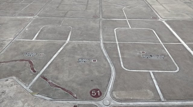 The map of Chandigarh at the plaza of sector 17. (Express Photo by Jasbir Malhi)
The Rs 90 lakh Chandigarh map which is being made on the ground of Sector 17 is soon going to see its project mapping now. The map will give virtual 3D images to people which will make them feel they are in that particular area when they step on it, an official said.
A senior official of the Chandigarh engineering wing said, “The map will give virtual 3D images in such a way that any person will get real feel. Like if someone goes at the railway station mark, he will get 3D virtual images of the railway station. The particular area will make them feel that way, the data will be fed in such a manner.”
Proper illumination will also be done, the official said. The map will be completed in three-month’s time, from now, it was further added. Even as the engineering wing is working in full swing, the map is being constructed despite strong resistance from heritage experts. The administration proceeded with the construction of a map of the city in Sector 17 at a cost of Rs 90 lakh. The map’s construction on the ground in Sector 17 had surprised the city’s architects.
The map witnessed opposition by a lot of architects, who did not approve of it. They had even said that for such a hefty amount, it was not going to serve the purpose also.
Moreover, it would be disrespectful to have the map of the city on the floor, with people walking over it, many had opposed.
Vinod Vashisht, Convener, City Forum of Residents Welfare Organisations (CFORWO) said that having a map on the ground is totally an unwarranted project. “Having a map in Sector 17 Plaza as one of the new tourist attractions at a hefty cost is a surprise element for most of the city residents, Sector 17 business promotion council and city-based architects,” Vashisht said.
He added, “For the last couple of years, the UT Administration and Chandigarh Smart City Limited have been holding idea generation competitions for the betterment of the city by inviting suggestions from residents and other stake holders from time to time, which is very good, administration should ensure that most city development projects go through similar citizen consultative processes. Not sure for Map at Plaza, whether even Chandigarh Smart City Department was consulted or not or whether it is in line with the Sector 17 Revitalization Plan. City’s urban development should be strictly guided by Chandigarh Master Plan-2031.”
Story continues below this ad
RK Garg, local resident and an activist said, “I would like to say that the administration has made many changes in Sector 17 which does not have any space in Master Plan, which is a duly notified document of this UT. We need to stop this ‘manmarzi’ of officers and develop this city according to duly notified plans only. Voice of people should not only be heard but followed also, as per rules,” Garg said.
He also added, “I have been told that Rejuvenation Plan of Sector 17 has not been presented to CHCC (Chandigarh Heritage Conservation Committee).”
The architects had even said that there are so many walls around and a map can be beautifully displayed there where the same can be illuminated as well.
It was questioned whether the map would serve the purpose if someone is trying to locate something and so many people are walking over it.
Story continues below this ad
The UT engineering officials, however, have said that the map on the floor will be illuminated with lights and it will serve as a centre of attraction too. Moreover, it was stated that “since people have to refer to different locations to look for places in Chandigarh, having it all together in just one map would be beneficial for tourists and visitors.”

Advertisement
Top Stories


Live Blog
Loading Taboola...
Advertisement